Clevedon, New Zealand
Clevedon, previously known as Wairoa South, is a rural town in Auckland, New Zealand, located in the Franklin ward, one of the thirteen administrative divisions of Auckland city. The town is governed by the Auckland Council. The town is the centre of an administrative ward of Franklin which takes in much of the largely rural area to the east of the urban heart of the city.
Clevedon | |
|---|---|
Town | |
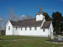 All Souls Church | |
| |
| Coordinates: 37°0′S 175°3′E | |
| Country | |
| Region | Auckland Region |
| Local board | Franklin Local Board |
| Ward | Franklin Ward |
| Population (2018) | |
| • Total | 1,515 |
| Website | Clevedon town website |
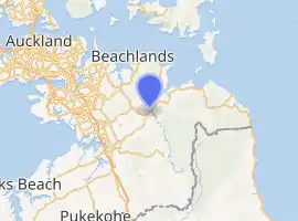
Clevedon is located on the Wairoa River five kilometres from its estuary and outflow into the Tamaki Strait, an arm of the Hauraki Gulf. It is 14 kilometres from the centre of the suburb of Manukau, which lies to the northwest. To the south of Clevedon rise the rugged hills of the Hunua Ranges. Several popular beaches are located on the coast close to Clevedon, including Duder's Beach and Kawakawa Bay. Between these two beaches lies the Duder Regional Park.
History and culture
Pre-European history
Prior to human settlement, the area was swampy, and is been a location where Bush moa, Mantell's moa and North Island giant moa bones have been found.[1] Clevedon and surrounding area is traditionally the territory of the Ngāi Tai or Ngāi Tai ki Tāmaki people, who are descendants of the Tainui waka. They call the area Te Wairoa (the Long River). Ngāi Tai traversed their tribal domain, including the inner islands of the Hauraki Gulf, in a seasonal cycle of harvesting, gathering and fishing.
Ngā Tai maintained settlements in several places, including:
- Otau and Tuawa near present-day Clevedon, in Te Wairoa River valley
- At Tararua near the mouth of the Rautawhiti Stream, in Te Wairoa River valley
- At Takatekauere, Te Totara, Te Ruato and Pehuwai on the western side of Te Wairoa River
- Te Oue, Mawherawhera, Te Kuiti and Umupuia, on the Whakakaiwhara Peninsula
European settlement
The European settlement of Clevedon was established in 1866. It was named after the English town of Clevedon.
All Souls Church, built in the Selwyn style and located in Clevedon, is registered by Heritage New Zealand as a Category II structure, with registration number 682.[2][3]
Marae
The local Umupuia Marae and Ngeungeu meeting house is a traditional meeting place for Ngāi Tai ki Tāmaki and the Waikato Tainui hapū of Ngāti Koheriki and Ngāi Tai.[4][5]
Demographics
| Year | Pop. | ±% p.a. |
|---|---|---|
| 2006 | 1,344 | — |
| 2013 | 1,452 | +1.11% |
| 2018 | 1,515 | +0.85% |
| Source: [6] | ||
The statistical area of Clevedon, which at 50 square kilometres is larger than the town, had a population of 1,515 at the 2018 New Zealand census, an increase of 63 people (4.3%) since the 2013 census, and an increase of 171 people (12.7%) since the 2006 census. There were 507 households. There were 762 males and 753 females, giving a sex ratio of 1.01 males per female. The median age was 43 years, with 294 people (19.4%) aged under 15 years, 261 (17.2%) aged 15 to 29, 756 (49.9%) aged 30 to 64, and 207 (13.7%) aged 65 or older.
Ethnicities were 92.5% European/Pākehā, 7.1% Māori, 1.8% Pacific peoples, 5.0% Asian, and 1.8% other ethnicities (totals add to more than 100% since people could identify with multiple ethnicities).
The proportion of people born overseas was 21.0%, compared with 27.1% nationally.
Although some people objected to giving their religion, 49.5% had no religion, 41.2% were Christian, 1.2% were Hindu, 0.2% were Muslim, 1.2% were Buddhist and 1.8% had other religions.
Of those at least 15 years old, 351 (28.7%) people had a bachelor or higher degree, and 144 (11.8%) people had no formal qualifications. The median income was $44,200. The employment status of those at least 15 was that 690 (56.5%) people were employed full-time, 234 (19.2%) were part-time, and 27 (2.2%) were unemployed.[6]
Education
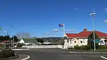
Clevedon School is a coeducational full primary school (years 1–8) with a roll of 367 as of March 2020.[7][8] The school began in 1859 as Wairoa School and moved to its current site in 1878. In 1895 it became Clevedon School.[9]
Notable people
- Phil Goff, politician and Auckland mayor
References
- Gill, B.J. (2003). "HISTORICAL MOA BONE COLLECTIONS (AVES: DINORNITHIFORMES) AT AUCKLAND MUSEUM—CLEVEDON AND KIA ORA". Records of the Auckland Museum. 40: 39–53. ISSN 1174-9202.
- "All Soul's Church (Anglican)". Register of Historic Places. Heritage New Zealand. Retrieved 7 July 2012.
- Knight, Cyril Roy. (1972). The Selwyn churches of Auckland. Wellington [N.Z.]: A.H. & A.W. Reed. p. 78. ISBN 0-589-00705-X. OCLC 596619.
- "Te Kāhui Māngai directory". tkm.govt.nz. Te Puni Kōkiri.
- "Māori Maps". maorimaps.com. Te Potiki National Trust.
- "Statistical area 1 dataset for 2018 Census". Statistics New Zealand. March 2020. Clevedon (162900). 2018 Census place summary: Clevedon
- "New Zealand Schools Directory". New Zealand Ministry of Education. Retrieved 26 April 2020.
- Education Counts: Clevedon School
- "Our History". Clevedon School. Retrieved 22 September 2020.
- Reed, A. W. (2002). The Reed Dictionary of New Zealand Place Names. Auckland: Reed Books. ISBN 0-7900-0761-4..
External links
| Wikimedia Commons has media related to Clevedon, New Zealand. |