Cohasset, Massachusetts
Cohasset is a small town in Norfolk County, Massachusetts, United States. As of the 2010 census the population was 7,542,[1] and in 2017 the estimated population was 8,516.[2]
Cohasset, Massachusetts | |
|---|---|
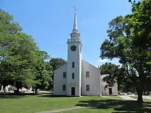
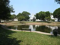 Cohasset Town Common | |
 Seal | |
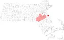 Location in Norfolk County in Massachusetts | |
| Coordinates: 42°14′30″N 70°48′15″W | |
| Country | |
| State | |
| County | |
| Settled | 1647 |
| Incorporated | 1770 |
| Government | |
| • Type | Open town meeting |
| Area | |
| • Total | 81.42 km2 (31.44 sq mi) |
| • Land | 25.35 km2 (9.79 sq mi) |
| • Water | 56.06 km2 (21.64 sq mi) |
| Elevation | 15 m (50 ft) |
| Population (2010)[1] | |
| • Total | 7,542 |
| • Estimate (2017) | 8,516[2] |
| • Density | 335.9/km2 (870/sq mi) |
| Time zone | UTC−5 (Eastern) |
| • Summer (DST) | UTC−4 (Eastern) |
| ZIP Code | 02025 |
| Area code(s) | 339/781 |
| FIPS code | 25-14640 |
| GNIS feature ID | 0618317 |
| Website | www |
History
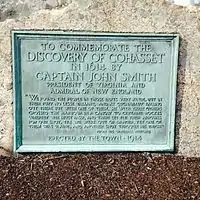
Cohasset was first seen by Europeans in 1614, when Captain John Smith explored the coast of New England. The area was first settled in 1670 and became a town separate from Hingham in 1770, 100 years later.[3] Previously, what is today the town of Cohasset was known as Hingham's Second Parish.[4] The town's name came from the Algonquian word "Conahasset", meaning "long rocky place". Much of the land was originally granted to the "Conahasset Partners".
At a special town meeting of January 1670, the shares in the new town were apportioned and divided among the new proprietors, many of whom were large Hingham landowners. The largest number of shares (35) went to Hingham Town Clerk Daniel Cushing, with the second largest (25) to Reverend Peter Hobart, Hingham's minister. Others receiving large grants were: Capt. Joshua Hobart, Peter Hobart's brother (18 shares); Lieut. John Smith (15 shares); Ensign John Thaxter (16½ shares); and deacon John Leavitt (with 14½ shares).[5] The layout of the town was distinctive. Many lots were laid out in long narrow strips, facilitating more lots with road frontage, and avoiding back lots.
Cohasset was originally part of Suffolk County, and when the southern part of the county was set off as Norfolk County in 1793, it included the towns of Cohasset, Hingham and Hull. In 1803, Hull and Hingham opted out of Norfolk County and became part of Plymouth County, leaving Cohasset as an exclave of Norfolk County.[6]
Geography

According to the United States Census Bureau, the town has a total area of 31.4 square miles (81.4 km2), of which 9.8 square miles (25.4 km2) are land and 21.7 square miles (56.1 km2), or 68.86%, are water.[7] It is bordered on the west by Hingham, on the northwest by Hull, on the north and northeast by Massachusetts Bay and on the east and south by Scituate. Cohasset is approximately 12 miles (19 km) east of Braintree and 20 miles (32 km) by road southeast of Boston.
Cohasset is located on the "corner" of the South Shore, where greater Boston Harbor ends and Massachusetts Bay begins. The shore is rocky, with many small ledges and rocks lying offshore. Cohasset Cove and The Gulf provide a long portion of the border with Scituate, while Straits Pond divides Cohasset from neighboring Hull. Near the center of the coast lies Little Harbor, a large inlet divided from the ocean by Beach Island. Several other brooks and rivers run through the town. A large portion of the southwestern part of town is occupied by Wompatuck State Park (formerly the Hingham Naval Ammunition Depot Annex), and the Whitney & Thayer Woods Reservation. There is also a bird sanctuary, as well as a large park (Wheelwright Park) near Little Harbor. There are three beaches along the bay, and the Cohasset Yacht Club, Cohasset Sailing Club and a public boat launch in Cohasset Harbor.
Climate
The climate in this area is characterized by hot, humid summers and generally mild to cool winters. According to the Köppen Climate Classification system, Cohasset has a humid subtropical climate, abbreviated "Cfa" on climate maps.[8]
January is the coldest month of the year with an average low temperature of 20 °F and average high of 37 °F. July is the warmest month of the year with an average low temperature of 62 °F and average high of 81 °F. Average monthly precipitation falls between 3.47" and 4.80" depending on the time of year. Additionally, Cohasset averages 14.2" of snow in its snowiest month (February) and 48.3" for the year. The all-time record low and high temperatures are -13 °F (1961) and 100 °F (2002), respectively.[9]
Government
On the national level, Cohasset is a part of Massachusetts's 8th congressional district, and is currently represented by Stephen Lynch. The senior (Class II) Senator, is Elizabeth Warren. The (Class I) member of the United States Senate is Edward Markey.
On the state level, Cohasset is represented in the Massachusetts House of Representatives by Joan Meschino as a part of the Third Plymouth district, which includes Hingham, Hull and Scituate. The town is represented in the Massachusetts Senate by Patrick O'Connor as a part of the Plymouth and Norfolk district, which includes the towns of Duxbury, Hingham, Hull, Marshfield, Norwell, Scituate and Weymouth.[10] The town is patrolled on a secondary basis by the First (Norwell) Barracks of Troop D of the Massachusetts State Police.[11]
Cohasset is governed on the local level by the open town meeting form of government, and is led by a town manager and a five-member board of selectmen. The current Town Manager is Christopher Senior. Selectmen are elected officials and serve three-year terms led by a chairman in a rotating one-year term. The current Board of Selectmen consists of Kevin McCarthy, Chair, Paul Schubert, Vice-Chair, and Diane Kennedy, Steve Gaumer, and Jack Keniley. The town operates its own police and fire departments, both of which are headquartered near the town center. Emergency services are also provided by the town, with patients taken to the South Shore Hospital in Weymouth. The town's post office is also nearby, just off of the town common. The town's Paul Pratt Memorial Library is located just west of the town center, in what was once a school adjacent to the original library.
Cohasset Schools are represented by and headed by the Cohasset School Committee. Members of the Cohasset School Committee are Jeanne Astino(Chairman), Katie Dugan(Vice-Chairman), Ellen Maher, Barbara Stefan and Amanda Zani.
| Voter registration and party enrollment as of February 12, 2020[12] | |||||
|---|---|---|---|---|---|
| Party | Number of voters | Percentage | |||
| Democratic | 1,302 | 22.07% | |||
| Republican | 1,079 | 18.29% | |||
| Unaffiliated | 3,496 | 59.25% | |||
| Minor parties | 23 | 0.39% | |||
| Total | 5,900 | 100% | |||
Demographics
| Year | Pop. | ±% |
|---|---|---|
| 1850 | 1,775 | — |
| 1860 | 1,953 | +10.0% |
| 1870 | 2,130 | +9.1% |
| 1880 | 2,182 | +2.4% |
| 1890 | 2,448 | +12.2% |
| 1900 | 2,759 | +12.7% |
| 1910 | 2,585 | −6.3% |
| 1920 | 2,639 | +2.1% |
| 1930 | 3,083 | +16.8% |
| 1940 | 3,111 | +0.9% |
| 1950 | 3,731 | +19.9% |
| 1960 | 5,840 | +56.5% |
| 1970 | 6,954 | +19.1% |
| 1980 | 7,174 | +3.2% |
| 1990 | 7,075 | −1.4% |
| 2000 | 7,261 | +2.6% |
| 2010 | 7,542 | +3.9% |
| 2017* | 8,516 | +12.9% |
| * = population estimate. Source: United States Census records and Population Estimates Program data.[13][14][15][16][17][18][19][20][21][22] | ||
As of the census of 2010, there were 7,542 people, 2,722 households, and 2,024 families residing in the town. The population density was 770.4 people per square mile (297.5/km2). There were 2,980 housing units, of which 258, or 8.7%, were vacant. The racial makeup of the town was 97.3% White, 0.3% African American, 0.1% Native American, 1.0% Asian, 0.01% Pacific Islander, 0.2% some other race, and 1.1% from two or more races. Hispanic or Latino of any race were 1.3% of the population.[23]
Of the 2,722 households in the town, 39.9% had children under the age of 18 living with them, 64.0% were headed by married couples living together, 7.8% had a female householder with no husband present, and 25.6% were non-families. 22.7% of all households were made up of individuals, and 12.8% were someone living alone who was 65 years of age or older. The average household size was 2.74, and the average family size was 3.27.[23]
29.4% of the town's population were under the age of 18, 4.3% were from 18 to 24, 18.6% were from 25 to 44, 31.6% were from 45 to 64, and 16.0% were 65 years of age or older. The median age was 43.6 years. For every 100 females, there were 96.5 males. For every 100 females age 18 and over, there were 90.9 males.[23]
For the period 2013–2017, the estimated median annual income for a household in the town was $140,000. The median income for a family was $180,345, and the per capita income was $75,885. Male full-time workers earned an estimated $124,420 per year, while females earned $91,103. About 2.5% of families and 3.8% of the population were below the poverty line, including 5.4% of those under age 18 and 1.6% of those age 65 or over.[24]
During the 2013-2017 period, the median home value was $852,300.[25] 98.3% of the town residents held at least a high school degree, while 73.3% had a bachelor's degree or higher.[26]
Education
Cohasset operates its own school department for the town's approximately 1,500 students. The Osgood Elementary School serves students from pre-kindergarten through second grade. The Deer Hill Elementary School, located adjacent to the Osgood School, serves students from grades 3–5. The town operates a combined Middle/High School, which is located just over Bear Hill from the other two schools. Cohasset's athletics teams are known as the Skippers, and their colors are navy blue and white. They compete in the South Shore League, and their chief rival is Hull High School.
The athletic programs offered to Cohasset High School students include Baseball, Ice Hockey, Basketball, Cross Country, Tennis, a Competitive Debate Team, Football (which won the 2014 Division VI Super Bowl, and made it to the 2013 Division VI Super Bowl, but lost), Soccer, Competitive Swimming, Track and Field, Sailing, Ski Team, Wrestling and Lacrosse.
High school students may also choose to attend South Shore Vocational Technical High School in Hanover free of charge. There are no private schools in Cohasset, but there are several in neighboring Hingham and the towns west of it.
Transportation
No divided highways run through Cohasset. The longest state route through the town is Route 3A, which curves through the town between Scituate and Hingham. Route 228 runs along the border with Hingham, crossing the Weir River into Hull. The nearest airport to Cohasset is Marshfield Municipal Airport. The nearest national and international air service can be reached at Logan International Airport in Boston. T. F. Green Airport, located outside Providence, Rhode Island, is an alternative to this airport, although it is located further away.
The MBTA bus system services the bordering town of Hingham. The MBTA's commuter rail Greenbush Line has a Cohasset station off Route 3A, just east of a cemetery.[27]
Media
Movies filmed in Cohasset:
- The Witches of Eastwick (1987), starring Cher, Susan Sarandon, Michelle Pfeiffer, and Jack Nicholson
- HouseSitter (1992), starring Goldie Hawn and Steve Martin
- The Finest Hours (2016), starring Chris Pine, Casey Affleck and Eric Bana
References
- "Population and Housing Occupancy Status: 2010 – State – County Subdivision, 2010 Census Redistricting Data (Public Law 94-171) Summary File". U.S. Census Bureau. Retrieved 2011-06-26.
- "Annual Estimates of the Resident Population: April 1, 2010 to July 1, 2017 (PEPANNRES): Massachusetts Minor Civil Divisions". American Factfinder. U.S. Census Bureau. Archived from the original on February 13, 2020. Retrieved December 10, 2018.
- ), Hingham (Mass (1893). History of the Town of Hingham, Massachusetts, Vol. I, Thomas Tracy Bouve et al., Published by the Town, 1893. Retrieved 2014-02-25.CS1 maint: numeric names: authors list (link)
- "Congregational History". First Parish of Cohasset. December 28, 2009. Archived from the original on July 26, 2011. Retrieved 2010-06-06.
- Bigelow, Edwin Victor (1898). A Narrative History of the Town of Cohasset, Massachusetts, Edwin Victor Bigelow, Published Under the Auspices of the Committee on Town History, Press of Samuel Usher, Boston, Mass., 1898. Retrieved 2014-02-25.
- "Information and Historical Data on Cities, Towns and Counties in Massachusetts". Sec.state.ma.us. Retrieved 2014-02-25.
- "Geographic Identifiers: 2010 Census Summary File 1 (G001): Cohasset town, Norfolk County, Massachusetts". American Factfinder. U.S. Census Bureau. Archived from the original on February 13, 2020. Retrieved December 10, 2018.
- "Climate Summary for Cohasset, Massachusetts". Weatherbase.com. Retrieved 2014-02-25.
- "Index of Legislative Representation by City and Town, from". Mass.gov. Retrieved 2014-02-25.
- Station D-1, SP Norwell Archived November 27, 2011, at the Wayback Machine
- "Registered Voters and Party Enrollment as of February 12, 2020" (PDF). Massachusetts Elections Division. Retrieved 2020-07-07.
- "Total Population (P1), 2010 Census Summary File 1". American FactFinder, All County Subdivisions within Massachusetts. United States Census Bureau. 2010.
- "Massachusetts by Place and County Subdivision - GCT-T1. Population Estimates". United States Census Bureau. Retrieved July 12, 2011.
- "1990 Census of Population, General Population Characteristics: Massachusetts" (PDF). US Census Bureau. December 1990. Table 76: General Characteristics of Persons, Households, and Families: 1990. 1990 CP-1-23. Retrieved July 12, 2011.
- "1980 Census of the Population, Number of Inhabitants: Massachusetts" (PDF). US Census Bureau. December 1981. Table 4. Populations of County Subdivisions: 1960 to 1980. PC80-1-A23. Retrieved July 12, 2011.
- "1950 Census of Population" (PDF). Bureau of the Census. 1952. Section 6, Pages 21-10 and 21-11, Massachusetts Table 6. Population of Counties by Minor Civil Divisions: 1930 to 1950. Retrieved July 12, 2011.
- "1920 Census of Population" (PDF). Bureau of the Census. Number of Inhabitants, by Counties and Minor Civil Divisions. Pages 21-5 through 21-7. Massachusetts Table 2. Population of Counties by Minor Civil Divisions: 1920, 1910, and 1920. Retrieved July 12, 2011.
- "1890 Census of the Population" (PDF). Department of the Interior, Census Office. Pages 179 through 182. Massachusetts Table 5. Population of States and Territories by Minor Civil Divisions: 1880 and 1890. Retrieved July 12, 2011.
- "1870 Census of the Population" (PDF). Department of the Interior, Census Office. 1872. Pages 217 through 220. Table IX. Population of Minor Civil Divisions, &c. Massachusetts. Retrieved July 12, 2011.
- "1860 Census" (PDF). Department of the Interior, Census Office. 1864. Pages 220 through 226. State of Massachusetts Table No. 3. Populations of Cities, Towns, &c. Retrieved July 12, 2011.
- "1850 Census" (PDF). Department of the Interior, Census Office. 1854. Pages 338 through 393. Populations of Cities, Towns, &c. Retrieved July 12, 2011.
- "Profile of General Population and Housing Characteristics: 2010 Census Summary File 1 (DP-1): Cohasset town, Norfolk County, Massachusetts". American Factfinder. U.S. Census Bureau. Archived from the original on February 14, 2020. Retrieved December 10, 2018.
- "Selected Economic Characteristics: 2013-2017 American Community Survey 5-Year Estimates (DP03): Cohasset town, Norfolk County, Massachusetts". American Factfinder. U.S. Census Bureau. Archived from the original on February 13, 2020. Retrieved December 10, 2018.
- "Selected Housing Characteristics: 2013-2017 American Community Survey 5-Year Estimates (DP04): Cohasset town, Norfolk County, Massachusetts". American Factfinder. U.S. Census Bureau. Archived from the original on February 13, 2020. Retrieved December 10, 2018.
- "Selected Social Characteristics in the United States: 2013-2017 American Community Survey 5-Year Estimates (DP02): Cohasset town, Norfolk County, Massachusetts". American Factfinder. U.S. Census Bureau. Archived from the original on February 13, 2020. Retrieved December 10, 2018.
- Greenbush Line Construction website Archived 2007-03-31 at the Wayback Machine
External links
| Wikivoyage has a travel guide for Cohasset. |
| Wikimedia Commons has media related to Cohasset, Massachusetts. |
Municipalities and communities of Norfolk County, Massachusetts, United States | ||
|---|---|---|
| Cities | 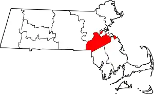 | |
| Towns | ||
| CDPs | ||
| Other villages | ||
| ||
| Authority control |
|---|