Coldwater, Kansas
Coldwater is a city in and the county seat of Comanche County, Kansas, United States.[7] As of the 2010 census, the city population was 828.[8]
Coldwater, Kansas | |
|---|---|
City and County seat | |
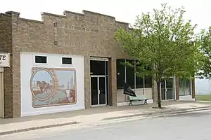 Comanche County Museum (2010) | |
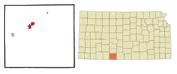 Location within Comanche County and Kansas | |
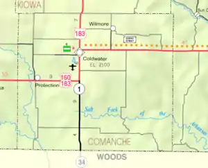 KDOT map of Comanche County (legend) | |
| Coordinates: 37°16′10″N 99°19′34″W | |
| Country | United States |
| State | Kansas |
| County | Comanche |
| Founded | 1884 |
| Incorporated | 1885 |
| Named for | Coldwater, Michigan |
| Area | |
| • Total | 2.90 sq mi (7.51 km2) |
| • Land | 2.56 sq mi (6.64 km2) |
| • Water | 0.34 sq mi (0.87 km2) |
| Elevation | 2,106 ft (642 m) |
| Population | |
| • Total | 828 |
| • Estimate (2019)[3] | 736 |
| • Density | 287.28/sq mi (110.91/km2) |
| Time zone | UTC-6 (CST) |
| • Summer (DST) | UTC-5 (CDT) |
| ZIP code | 67029 [4] |
| Area code | 620 |
| FIPS code | 20-14700 [5] |
| GNIS ID | 0470738 [6] |
| Website | coldwaterks.org |
History
In 1884 G.W. Vickers, conceived the idea of laying out a town in the northern part of Comanche County, in company with Timothy Shields, J. P. Grove, Samuel Sisson, C. M. Cade and C. D. Bickford, all from Harper County. They preempted a section of land, had it platted off as a town site and named it after the city of Coldwater, Michigan.[9] Early the following year the county had the required number of inhabitants, who petitioned the governor for its organization, and on February 27, 1885, it was organized with Owen Connaughton, George M. Morris and David T. Mclntire, commissioners and R. A. Grossman, clerk. Coldwater was designated as the county seat.[10]
The first post office in Coldwater was established on October 17, 1884.[11]
Geography
According to the United States Census Bureau, the city has a total area of 2.98 square miles (7.72 km2), of which, 2.64 square miles (6.84 km2) is land and 0.34 square miles (0.88 km2) is water.[12]
Climate
The climate in this area is characterized by hot, humid summers and generally mild to cool winters. According to the Köppen Climate Classification system, Coldwater has a humid subtropical climate, abbreviated "Cfa" on climate maps.[13]
Area attractions
- Comanche County Historical Museum, 105 West Main Street.
- Chief Theater (NRHP), 122 East Main Street.
- Comanche County Courthouse (NRHP), 201 South New York Avenue.
Demographics
| Historical population | |||
|---|---|---|---|
| Census | Pop. | %± | |
| 1890 | 480 | — | |
| 1900 | 263 | −45.2% | |
| 1910 | 684 | 160.1% | |
| 1920 | 1,207 | 76.5% | |
| 1930 | 1,296 | 7.4% | |
| 1940 | 1,214 | −6.3% | |
| 1950 | 1,208 | −0.5% | |
| 1960 | 1,164 | −3.6% | |
| 1970 | 1,016 | −12.7% | |
| 1980 | 989 | −2.7% | |
| 1990 | 939 | −5.1% | |
| 2000 | 792 | −15.7% | |
| 2010 | 828 | 4.5% | |
| 2019 (est.) | 736 | [3] | −11.1% |
| U.S. Decennial Census | |||
2010 census
As of the census[2] of 2010, there were 828 people, 380 households, and 217 families residing in the city. The population density was 313.6 inhabitants per square mile (121.1/km2). There were 458 housing units at an average density of 173.5 per square mile (67.0/km2). The racial makeup of the city was 97.2% White, 0.1% African American, 0.2% Native American, 0.1% Asian, 0.1% Pacific Islander, 0.2% from other races, and 1.9% from two or more races. Hispanic or Latino of any race were 2.5% of the population.
There were 380 households, of which 26.8% had children under the age of 18 living with them, 45.5% were married couples living together, 7.6% had a female householder with no husband present, 3.9% had a male householder with no wife present, and 42.9% were non-families. 39.5% of all households were made up of individuals, and 18.9% had someone living alone who was 65 years of age or older. The average household size was 2.12 and the average family size was 2.81.
The median age in the city was 46.1 years. 23.3% of residents were under the age of 18; 5.7% were between the ages of 18 and 24; 19.2% were from 25 to 44; 26.8% were from 45 to 64; and 25.1% were 65 years of age or older. The gender makeup of the city was 47.5% male and 52.5% female.
2000 census
As of the census[5] of 2000, there were 792 people, 380 households, and 209 families residing in the city. The population density was 301.3 people per square mile (116.3/km2). There were 460 housing units at an average density of 175.0 per square mile (67.5/km2). The racial makeup of the city was 98.11% White, 0.13% African American, 0.63% Native American, 0.13% Pacific Islander, 0.13% from other races, and 0.88% from two or more races. Hispanic or Latino of any race were 2.15% of the population.
There were 380 households, out of which 20.3% had children under the age of 18 living with them, 46.6% were married couples living together, 8.4% had a female householder with no husband present, and 45.0% were non-families. 42.9% of all households were made up of individuals, and 28.2% had someone living alone who was 65 years of age or older. The average household size was 2.01 and the average family size was 2.75.
In the city, the population was spread out, with 20.3% under the age of 18, 5.4% from 18 to 24, 17.9% from 25 to 44, 24.6% from 45 to 64, and 31.7% who were 65 years of age or older. The median age was 50 years. For every 100 females, there were 80.8 males. For every 100 females age 18 and over, there were 76.8 males.
The median income for a household in the city was $27,167, and the median income for a family was $36,786. Males had a median income of $23,438 versus $16,625 for females. The per capita income for the city was $16,851. About 8.7% of families and 9.8% of the population were below the poverty line, including 8.8% of those under age 18 and 8.9% of those age 65 or over.
Education
The community is served by Comanche County USD 300 public school district. South Central High School is located in Coldwater.[14]
Coldwater High School closed because of school unification.
Infrastructure
Transportation
U.S. Route 160 and U.S. Route 183 passes through Coldwater.
Notable people
- Chick Brandom, baseball player
- Harold Herd, former Kansas Supreme Court justice (1979–1993), minority leader in Kansas State Senate (1969–1973), mayor of Coldwater (1950–1954), officer in the U.S. Navy during World War II.
References
- "2019 U.S. Gazetteer Files". United States Census Bureau. Retrieved July 24, 2020.
- "U.S. Census website". United States Census Bureau. Retrieved 2012-07-06.
- "Population and Housing Unit Estimates". United States Census Bureau. May 24, 2020. Retrieved May 27, 2020.
- United States Postal Service (2012). "USPS - Look Up a ZIP Code". Retrieved 2012-02-15.
- "U.S. Census website". United States Census Bureau. Retrieved 2008-01-31.
- "US Board on Geographic Names". United States Geological Survey. 2007-10-25. Retrieved 2008-01-31.
- "Find a County". National Association of Counties. Archived from the original on 2011-05-31. Retrieved 2011-06-07.
- "2010 City Population and Housing Occupancy Status". U.S. Census Bureau. Retrieved March 27, 2011.
- Gannett, Henry (1905). The Origin of Certain Place Names in the United States. Govt. Print. Off. pp. 87.
- History of Comanche County, Kansas. A Cyclopedia of State History. Frank Wilson Blackmar, 1912.
- "Kansas Post Offices, 1828-1961". Kansas Historical Society. Retrieved 6 June 2014.
- "US Gazetteer files 2010". United States Census Bureau. Archived from the original on 2012-07-02. Retrieved 2012-07-06.
- Climate Summary for Coldwater, Kansas
- "High School". South Central USD 300. Retrieved February 5, 2018.
Further reading
External links
| Wikimedia Commons has media related to Coldwater, Kansas. |
Municipalities and communities of Comanche County, Kansas, United States | ||
|---|---|---|
| Cities | 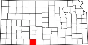 Map of Kansas highlighting Comanche County | |
| Unincorporated community | ||
| Townships | ||
| ||