Colorado State Highway 167
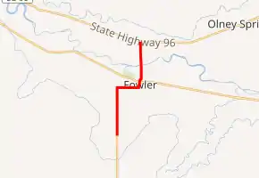
State Highway 167 (SH 167) is a 4.86 mi-long (7.82 km) state highway near Fowler, Colorado. SH 167 begins at the intersection of County Road 2 and County Road JJ south of Fowler and ends at SH 96 north of Fowler.
| ||||
|---|---|---|---|---|
| ||||
| Route information | ||||
| Maintained by CDOT | ||||
| Length | 4.860 mi[1] (7.821 km) | |||
| Major junctions | ||||
| South end | CR 2 / CR JJ south of Fowler | |||
| North end | ||||
| Location | ||||
| Counties | Crowley, Otero | |||
| Highway system | ||||
Colorado State Highways
| ||||

Route description
SH 167 runs for 4.860 miles (7.821 km), starting at the intersection of County Road 2 and County Road JJ south of Fowler. The highway goes north until it reaches CR LL west of Fowler. The highway then turns east until it passes by Fowler Jr/Sr High School and enters town as Grant Avenue. SH 167 then heads northeast through downtown and intersects U.S. Highway 50, then crosses the Arkansas River after it goes north of town. SH 167 then terminates at SH 96.
Major intersections
| County | Location | mi[1] | km | Destinations | Notes |
|---|---|---|---|---|---|
| Otero | | 4.860 | 7.821 | CR 2 south / CR JJ west | Roadway continues as CR 2 |
| Fowler | 1.673 | 2.692 | |||
| Crowley | | 0.000 | 0.000 | ||
1.000 mi = 1.609 km; 1.000 km = 0.621 mi
| |||||
References
- "Highway Data Explorer". Colorado Department of Transportation. Retrieved December 30, 2020.
External links
This article is issued from Wikipedia. The text is licensed under Creative Commons - Attribution - Sharealike. Additional terms may apply for the media files.