Colorado State Highway 170
State Highway 170 (SH 170) is a state highway in Colorado that connects Eldorado Springs and Superior. SH 170's western terminus is at Eldorado Canyon State Park, and the eastern terminus is at U.S. Route 36 (US 36) in Superior.
| ||||
|---|---|---|---|---|
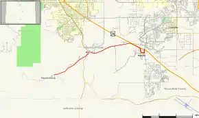 Map of Boulder County in north central Colorado with SH 170 highlighted in red | ||||
| Route information | ||||
| Maintained by CDOT | ||||
| Length | 6.969 mi[1] (11.216 km) | |||
| Major junctions | ||||
| West end | Eldorado Canyon State Park | |||
| East end | ||||
| Location | ||||
| Counties | Boulder | |||
| Highway system | ||||
Colorado State Highways
| ||||

Route description
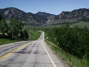
The road begins at the edge of Eldorado Canyon State Park at El Dorado Springs as a dirt road. Speed limit in this area is at 10 mph. As the route leaves Downtown Eldorado Springs, it becomes a paved road and the speed limit increases to 25 mph. . SH 170 then heads eastward, meeting County Road 67 before passing through a rural grassy area. The route then meets SH 93, where it becomes Marshall Drive, just north of Marshall Lake. The road then finds its eastern terminus at US 36, the Denver-Boulder Turnpike, passing through the city of Superior.[2]
Major intersections
The entire route is in Boulder County.
| Location | mi | km | Destinations | Notes | ||
|---|---|---|---|---|---|---|
| Eldorado Springs | 0.000 | 0.000 | Eldorado Canyon State Park | Western terminus | ||
| | 2.735 | 4.402 | ||||
| Superior | 6.969 | 11.216 | Eastern Terminus; Diverging Diamond Interchange; | |||
1.000 mi = 1.609 km; 1.000 km = 0.621 mi
| ||||||
References
- "Segment list for SH 170". Retrieved 2011-01-20.
- Microsoft; Nokia (2011-01-24). "SH 170" (Map). Bing Maps. Microsoft. Retrieved 2011-01-24.