Colorado State Highway 69
State Highway 69 (SH 69) is an 82.664-mile-long (133.035 km) state highway in the US state of Colorado. SH 69's western terminus is at U.S. Route 50 (US 50) in Texas Creek, and the eastern terminus is at Interstate 25 Business (I-25 Bus.) north of Walsenburg.
| ||||
|---|---|---|---|---|
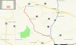 Map of south central Colorado with SH 69 highlighted in red | ||||
| Route information | ||||
| Maintained by CDOT | ||||
| Length | 82.664 mi[1] (133.035 km) | |||
| Major junctions | ||||
| West end | ||||
| East end | ||||
| Location | ||||
| Counties | Huerfano, Custer, Fremont | |||
| Highway system | ||||
Colorado State Highways
| ||||

Route description
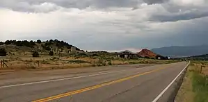
SH 69 with Calumet in the background
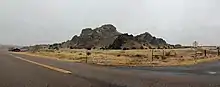
SH 69 with Gardner Butte in the background
SH 69 starts at a junction with I-25 Bus. just north of Walsenburg. The highway heads northwest over Long Saddle Pass and Promontory Divide Pass to Westcliffe and ends at the Texas Creek junction with US 50 between Cañon City and Salida.
Major intersections
| County | Location | mi | km | Destinations | Notes |
|---|---|---|---|---|---|
| Huerfano | | 0.000 | 0.000 | Eastern terminus | |
| Custer | Westcliffe | 58.705 | 94.477 | Western terminus of SH 96 | |
| Fremont | Texas Creek | 82.664 | 133.035 | Western terminus | |
| 1.000 mi = 1.609 km; 1.000 km = 0.621 mi | |||||
References
- "Segment list for SH 69". Retrieved 2011-01-21.
External links
This article is issued from Wikipedia. The text is licensed under Creative Commons - Attribution - Sharealike. Additional terms may apply for the media files.