Colorado State Highway 71
State Highway 71 (CO 71 or SH 71) is a 224-mile-long (360 km) state highway passing several other highways in northern and central Colorado. SH 71's southern terminus is at U.S. Route 350 (US 350) near La Junta, and the northern terminus is a continuation as Nebraska Highway 71 (N-71) at the Nebraska border.
| ||||
|---|---|---|---|---|
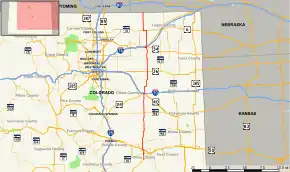 Map of eastern Colorado with SH 71 highlighted in red | ||||
| Route information | ||||
| Maintained by CDOT | ||||
| Length | 224.65 mi[1] (361.54 km) | |||
| Major junctions | ||||
| South end | ||||
| North end | ||||
| Location | ||||
| Counties | Otero, Crowley, Lincoln, Washington, Morgan, Weld | |||
| Highway system | ||||
Colorado State Highways
| ||||

Route description
SH 71 begins at its southern terminus with US 330 in La Junta, Colorado. It proceeds north into Crowley County and the city of Ordway, where it is signed as Phantom Avenue. The highway continues northward to a junction with Interstate 70 (I-70) adjacent to US 24.
In La Junta, the highway continues north for several miles to Ordway, then it takes a northeast turn to Limon. It then goes back north and skirts the town of Brush. It then heads through rural country to Nebraska
In Stoneham, the state portion of the road overlaps County Road 142 and heads to the north. The route takes a northeast turn and continues in to Nebraska as N-71.
Major intersections
| County | Location | mi | km | Destinations | Notes |
|---|---|---|---|---|---|
| Otero | | 0.00 | 0.00 | Southern terminus | |
| | 9.03 | 14.53 | south end of SH 10 overlap | ||
| | 9.6 | 15.4 | north end of SH 10 overlap | ||
| Rocky Ford | 14.54 | 23.40 | south end of US 50 overlap; western terminus of SH 66 | ||
| Eastern terminus of SH 202 | |||||
| | 16.16 | 26.01 | north end of US 50 overlap | ||
| Crowley | Ordway | 26.65 | 42.89 | south end of SH 96 overlap | |
| 26.88 | 43.26 | north end of SH 96 overlap | |||
| Lincoln | Punkin Center | 72.6 | 116.8 | ||
| Limon | 101.06 | 162.64 | south end of US 24 / US 40 / US 287 overlap | ||
| 101.97 | 164.10 | north end of US 24 / US 40 / US 287 overlap | |||
| Washington | Last Chance | 138.02 | 222.12 | ||
| Morgan | | 174.36 | 280.61 | south end of US 34 overlap | |
| Brush | 175.49 | 282.42 | north end of US 34 overlap | ||
| 176.45 | 283.97 | I-76 exit 90. (Denver is not explicitly signed for I-76 West at the intersection - only Fort Morgan) | |||
| Weld | | 201.64 | 324.51 | south end of SH 14 overlap | |
| | 205.52 | 330.75 | north end of SH 14 overlap | ||
| | 232.9 | 374.8 | Continues north at Nebraska state line | ||
1.000 mi = 1.609 km; 1.000 km = 0.621 mi
| |||||
References
- "Segment list for SH 71". Retrieved 2007-05-12.
External links
- Colorado Routes 60-79 The Highways of Colorado