Combe Bottom
Combe Bottom is a 42.1-hectare (104-acre) biological Site of Special Scientific Interest north of Shere in Surrey.[1][2] It is designated a Local Nature Reserve called Shere Woodlands,[3][4] and is managed by the Surrey Wildlife Trust.[5]
| Site of Special Scientific Interest | |
 | |
| Area of Search | Surrey |
|---|---|
| Grid reference | TQ 069 489[1] |
| Interest | Biological |
| Area | 42.1 hectares (104 acres)[1] |
| Notification | 1988[1] |
| Location map | Magic Map |
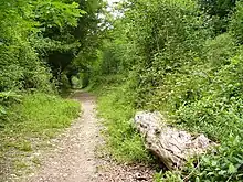
This site on a slope of the North Downs is mainly woodland and scrub, with a small area of unimproved chalk grassland. The woodland is dominated by beech and yew. There is a wide variety of bryophytes, including the rare moss Herzogiella seligeri.[6]
There is access from Staple Lane and Combe Lane.
References
- "Designated Sites View: Combe Bottom". Sites of Special Scientific Interest. Natural England. Retrieved 7 November 2018.
- "Map of Combe Bottom". Sites of Special Scientific Interest. Natural England. Retrieved 7 November 2018.
- "Shere Woodlands". Local Nature Reserves. Natural England. Retrieved 7 November 2018.
- "Map of Shere Woodlands". Local Nature Reserves. Natural England. Retrieved 7 November 2018.
- "Shere Woodlands (inc. West Hanger, Combe Bottom & Netley Plantation)". Surrey Wildlife Trust. Retrieved 7 November 2018.
- "Combe Bottom citation" (PDF). Sites of Special Scientific Interest. Natural England. Retrieved 7 November 2018.
| Wikimedia Commons has media related to Combe Bottom. |
- "citation". Sites of Special Scientific Interest. Natural England. Missing or empty
|url=(help)
This article is issued from Wikipedia. The text is licensed under Creative Commons - Attribution - Sharealike. Additional terms may apply for the media files.