List of counties in Arizona
There are 15 counties in the U.S. state of Arizona.[1] Four counties (Mohave, Pima, Yavapai and Yuma) were created in 1864 following the organization of the Arizona Territory in 1862. The now defunct Pah-Ute County was split from Mohave County in 1865, but merged back in 1871. All but La Paz County were created by the time Arizona was granted statehood in 1912. La Paz County was established in 1983 after many years of pushing for independence from Yuma County.[2]
| Counties of Arizona | |
|---|---|
| Category | Federal Unit |
| Location | State of Arizona |
| Number | 15 |
| Populations | 9,498 (Greenlee) – 4,485,414 (Maricopa) |
| Areas | 1,238 square miles (3,210 km2) (Santa Cruz) – 18,661 square miles (48,330 km2) (Coconino) |
| Government | County government |
| Subdivisions | cities, towns, unincorporated communities, census designated place |

Eight of Arizona's fifteen counties are named after various Native American groups that are resident in parts of what is now Arizona, with another (Cochise County) being named after a native leader. Four other counties, Gila County, Santa Cruz County, Pinal County, and Graham County, are named for physical features of Arizona's landscape: the Gila River, the Santa Cruz River, Pinal Peak, and Mount Graham, respectively. Another county, La Paz County, is named after a former settlement, while the final county, Greenlee County, is named after one of the state's early pioneers.[3]
Under Arizona laws, a county shall not be formed or divided by county initiative unless each proposed county would have all of the following characteristics: (1) at least three-fourths of one percent of the total state assessed valuation and at least the statewide per capita assessed valuation; (2) a population of at least three-fourths of one percent of the total state population according to the most recent United States decennial census; (3) at least one hundred square miles of privately owned land; (4) common boundaries with either (a) at least three other existing or proposed counties; or (b) at least two other existing or proposed counties and the state boundary.[4] A county formation commission is required to be formed to evaluate the feasibility of the proposed county.[5] A proposal to divide a county must be approved by a majority of the votes cast in each proposed new county.[6]
Under the Arizona Constitution, counties are politically and legally creatures of the state, and do not have charters of their own. Counties are governed by boards of supervisors which act in the capacity of executive authority for the county within the statutes and powers prescribed by Arizona state law. With few exceptions, these powers are narrowly construed. The state legislature devotes considerable time to local matters, with limited discretion granted to the Board of Supervisors on minor ordinance, zoning, and revenue collection issues.
Arizona's postal abbreviation is AZ and its FIPS code is 04.
Alphabetical listing
| County |
FIPS code[7] | County seat[8] | Est.[8] | Formed from[2] | Etymology[3] | Population[8][9] | Area[8][9] | Map |
|---|---|---|---|---|---|---|---|---|
| Apache County | 001 | St. Johns | 1879 | Yavapai County | The Apache (Ndee) people. Apache is an exonym from Zuni ʔapaču "Navajos" or Yavapai ʔpačə "enemy". | 71,887 | 11,218 sq mi (29,054 km2) |  |
| Cochise County | 003 | Bisbee | 1881 | Pima County | Cochise, a Chiricahua Apache chief and leader of an 1861 uprising. Cochise is an anglicisation of K'uu-ch'ish "oak". | 125,922 | 6,219 sq mi (16,107 km2) | 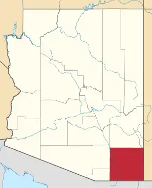 |
| Coconino County | 005 | Flagstaff | 1891 | Yavapai County | Coconino is a former designation for the Havasupai, Hualapai, and/or Yavapai, derived from the Hopi exonym Kohonino. | 143,476 | 18,661 sq mi (48,332 km2) | 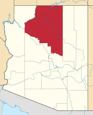 |
| Gila County | 007 | Globe | 1881 | Maricopa and Pinal Counties | The Gila River, a tributary of the Colorado. Possibly from Apache dzil "mountain," via Spanish Xila. | 54,018 | 4,796 sq mi (12,422 km2) |  |
| Graham County | 009 | Safford | 1881 | Apache and Pima Counties | Mount Graham, in the Pinaleños. Mt. Graham itself is named for topographical engineer James Duncan Graham.[10] | 38,837 | 4,641 sq mi (12,020 km2) |  |
| Greenlee County | 011 | Clifton | 1909 | Graham County | Mason Greenlee, early prospector. Named by an amendment initially intended to delay the bill creating "Lincoln County".[11] | 9,498 | 1,848 sq mi (4,786 km2) | 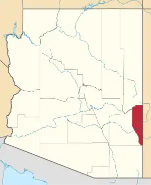 |
| La Paz County | 012 | Parker | 1983 | Yuma County | La Paz, Arizona, a historic boomtown on the Colorado River. A common placename, La Paz means "The Peace" in Spanish. | 21,108 | 4,513 sq mi (11,689 km2) | 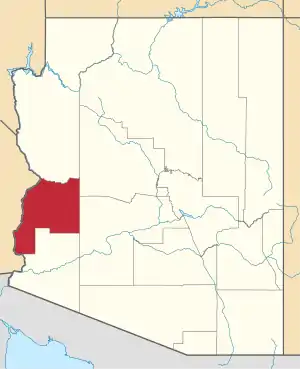 |
| Maricopa County | 013 | Phoenix | 1871 | Pima and Yavapai Counties | The Maricopa (Piipaash) people. First attested in Spanish as Cocomaricopa, no origin or meaning is definitively known. | 4,485,414 | 9,224 sq mi (23,890 km2) | 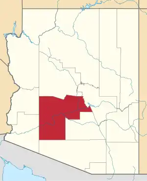 |
| Mohave County | 015 | Kingman | 1864 | — | The Mohave (Aha Makhav) people. The Mohave endonym means "along the water," referring to the Colorado.[12] | 212,181 | 13,470 sq mi (34,887 km2) | 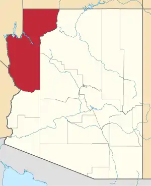 |
| Navajo County | 017 | Holbrook | 1895 | Apache County | The Navajo (Diné) people. Navajo is an exonym from Tewa Navahu "big field," referring to the San Juan River Valley | 110,924 | 9,959 sq mi (25,794 km2) | 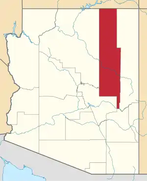 |
| Pima County | 019 | Tucson | 1864 | — | The Pima (Akimel O'odham) people. Pima is a Spanish exonym from the O'odham phrase pi mac "(I) don't know," presumably heard during initial encounters. | 1,047,279 | 9,189 sq mi (23,799 km2) | 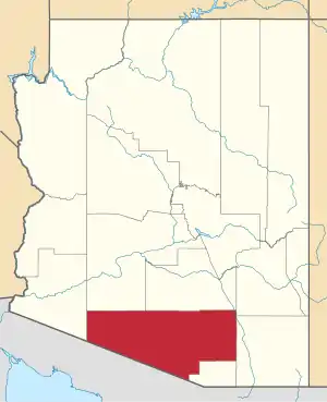 |
| Pinal County | 021 | Florence | 1875 | Maricopa and Pima counties | Pinal Peak, possibly from Spanish pinal "place of pines". Pinal Peak is now within the borders of Gila County. | 462,789 | 5,374 sq mi (13,919 km2) | 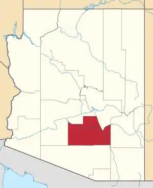 |
| Santa Cruz County | 023 | Nogales | 1899 | Cochise and Pima counties | Santa Cruz River, a tributary of the Gila. A common placename, Santa Cruz means "Holy Cross" in Spanish. | 46,498 | 1,238 sq mi (3,206 km2) | 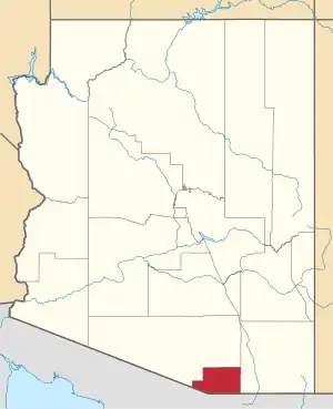 |
| Yavapai County | 025 | Prescott | 1864 | — | The Yavapai people. The Yavapé are one of four major Yavapai bands. | 235,099 | 8,128 sq mi (21,051 km2) |  |
| Yuma County | 027 | Yuma | 1864 | — | Yuma is a former name of the Quechan people, derived from the O'odham exonym Yumĭ. | 213,787 | 5,519 sq mi (14,294 km2) | 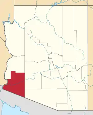 |
Excluded counties

Extinct counties
- Pah-Ute County, Arizona Territory (1865–1871), now part of Clark County, Nevada and Mohave County, Arizona
Proposed counties
- Butte County: In 1897, James C. Goodwin, with the support of Charles T. Hayden and others, introduced a bill at the Territorial Legislature to split Maricopa County into two, with Tempe being the county seat.[13][14] There have also been proposals, introduced in 1900 and 1913, to divide Maricopa County, with Mesa as the new county's seat.[14]
- Sierra Bonita County: proposed at the 13th Arizona Territorial Legislature in 1885, with Willcox proposed as the county seat. The proposal died by one vote.[15]
See also
- Bannon County, a fictional county in Arizona, was the site of the UFO crash in the film Hangar 18.
- Arizona Association of Counties
References
- "Find A County". uscounties.org. Archived from the original on September 5, 2012. Retrieved April 7, 2012.
- Adams, Ward R. (1997). History of Arizona. Higginson Book Company. ISBN 0-8328-7044-7.
- Kane, Joseph & Aiken, Charles (2004). The American Counties: Origins of County Names, Dates of Creation, and Population Data, 1950–2000. Scarecrow Press. p. 333. ISBN 0-8108-5036-2.
arizona county origins.
- Ariz. Rev. Stat. § 11-132(B)
- Ariz. Rev. Stat. § 11-136
- Ariz. Rev. Stat. § 11-137(H)
- "EPA County FIPS Code Listing". EPA. Archived from the original on September 28, 2004. Retrieved April 9, 2007.
- National Association of Counties. "NACo – Find a county". Archived from the original on April 10, 2005. Retrieved April 30, 2008.
- "Arizona QuickFacts". U.S. Census Bureau. Archived from the original on October 6, 2008. Retrieved July 17, 2007. (2000 Census)
- "A Little Bit of Mount Graham History". University of Arizona. Archived from the original on February 27, 2014. Retrieved March 1, 2015.
- "History of Greenlee County: Mason Greenlee". Greenlee County Government. Archived from the original on February 19, 2014. Retrieved July 20, 2007.
- "The Name Mojave". Mojave Desert Heritage and Cultural Association. Archived from the original on February 13, 2015. Retrieved March 1, 2015.
- Rowe, Jeremy (2011). Early Maricopa County: 1871–1920. Arcadia Publishing. p. 39. ISBN 978-0-7385-7416-5. Retrieved November 15, 2017.
- Mark, Jay (January 12, 2017). "Tempe history: Tempe – Seat of Butte County". The Arizona Republic. Retrieved November 15, 2017.
- McClintock, James H. (1916). Arizona, Prehistoric, Aboriginal, Pioneer, Modern: The Nation's Youngest Commonwealth Within a Land of Ancient Culture, Volume 2. Arizona: S. J. Clarke publishing Company. p. 334. Retrieved February 17, 2017.