Conifer Grove
Conifer Grove is an upper-middle class suburb of Auckland, in northern New Zealand. Located on the eastern shores of the Pahurehure Inlet, on the Manukau Harbour, under authority of the Auckland Council. The suburb makes up the western side of the Takanini urban area and is in the Manurewa-Papakura ward of Auckland City. The suburb is known for its tree-lined streets,[1] bay views, and until 2018 its border with the Manukau Golf Course.[2]
Conifer Grove | |
|---|---|
Suburb | |
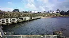
 Coastal path | |

| |
| Country | New Zealand |
| Local authority | Auckland City |
| Electoral ward | Manurewa-Papakura Ward |
| Local board | Papakura Local Board |
| Established | 1960 |
| Population (2018) | |
| • Total | 4,710 |
| Wattle Downs | Manurewa East | Takanini |
| (Manukau Harbour), Wattle Downs |
|
Takanini |
| (Manukau Harbour) | (Manukau Harbour) | Papakura North |
History
Conifer Grove was constructed around 1965-1970. Conifer Grove's modern area (including Keywella Drive, Aristoy Close and Chippewa Place) was previously a dairy farm owned by the Strevens family, which connected onto Great South Road and is now the Manukau Golf Course. The names Walter Strevens Drive and Walter Strevens reserve come from the name of the patriarch of that family at the time it was sold - Walter John Strevens.
Fraser Thomas were commissioned to design the subdivision and to manage its construction. Fraser Thomas were awarded Certificates of Merit by both the Association of Consulting Engineers NZ and the New Zealand Institute of Surveyors.[3]
During the major reformation of local government in 1989, Conifer Grove was re-zoned and the area was included into the Papakura District boundaries.
From October 2010, after a review of the Royal Commission on Auckland Governance, the entire Auckland Region was amalgamated into a single city authority. As well as the current Papakura District, other territorial authorities have been abolished and the entire area has been dissolved into a single Auckland city council. The suburb of Conifer Grove is now be in the Manurewa-Papakura Ward of the Auckland Council.
Demographics
| Year | Pop. | ±% p.a. |
|---|---|---|
| 2006 | 4,572 | — |
| 2013 | 4,617 | +0.14% |
| 2018 | 4,710 | +0.40% |
| Source: [4] | ||
Conifer Grove, comprising the statistical areas of Conifer Grove West and Conifer Grove East, had a population of 4,710 at the 2018 New Zealand census, an increase of 93 people (2.0%) since the 2013 census, and an increase of 138 people (3.0%) since the 2006 census. There were 1,551 households. There were 2,310 males and 2,400 females, giving a sex ratio of 0.96 males per female, with 960 people (20.4%) aged under 15 years, 942 (20.0%) aged 15 to 29, 2,160 (45.9%) aged 30 to 64, and 651 (13.8%) aged 65 or older.
Ethnicities were 63.4% European/Pākehā, 20.3% Māori, 13.3% Pacific peoples, 17.6% Asian, and 2.9% other ethnicities (totals add to more than 100% since people could identify with multiple ethnicities).
The proportion of people born overseas was 26.0%, compared with 27.1% nationally.
Although some people objected to giving their religion, 42.3% had no religion, 38.2% were Christian, 3.2% were Hindu, 1.4% were Muslim, 1.2% were Buddhist and 7.2% had other religions.
Of those at least 15 years old, 678 (18.1%) people had a bachelor or higher degree, and 675 (18.0%) people had no formal qualifications. The employment status of those at least 15 was that 2,019 (53.8%) people were employed full-time, 456 (12.2%) were part-time, and 162 (4.3%) were unemployed.[4]
Facilities
Conifer Grove has a small shopping centre. There are various parks/reserves such as Brylee Drive Reserve with two tennis courts and playground. This links to a board walk which goes around the waters/mangroves edge, which is enjoyed by many of the residents. This walk has been extended to connect the boardwalk through to Walter Strevens Drive reserve.
Most of the streets are cul-de-sacs. Due to the suburbs design pattern, there is only one way in and out of the newer area of Conifer Grove. This roundabout also has a security camera which records vehicle movement in and out of the area.
Education
Conifer Grove School is a coeducational full primary school (years 1–8) with a roll of 482 as of March 2020.[5][6] It is zoned primarily for Rosehill College.
External links
- Auckland Council
- (Conifer Grove School Website)
- Photographs of Conifer Grove held in Auckland Libraries' heritage collections.
References
- Easther, Elisabeth (11 August 2012). "My Auckland: Conifer Grove". NZ Herald. ISSN 1170-0777. Retrieved 1 January 2019.
- anne.gibson@nzherald.co.nz @anneherald, Anne Gibson Property editor, NZ Herald (1 April 2015). "$175m South Auckland retirement village planned". NZ Herald. ISSN 1170-0777. Retrieved 1 January 2019.
- Conifer Grove Archived 9 October 2007 at the Wayback Machine (from the Fraser Thomas website. Accessed 2008-03-16.)
- "Statistical area 1 dataset for 2018 Census". Statistics New Zealand. March 2020. Conifer Grove West (161800) and Conifer Grove East (161900). 2018 Census place summary: Conifer Grove West 2018 Census place summary: Conifer Grove East
- "New Zealand Schools Directory". New Zealand Ministry of Education. Retrieved 26 April 2020.
- Education Counts: Conifer Grove School