Connecticut Route 2
Route 2 is a 58.03-mile (93.39 km) state highway in Hartford and New London counties in Connecticut. It is a primary state route, with a limited-access freeway section connecting Hartford to Norwich and following surface roads to Stonington. The entire freeway section of Route 2 is also known as the Veterans of Foreign Wars Memorial Highway.[1]
| |||||||
|---|---|---|---|---|---|---|---|

Route 2 highlighted in red | |||||||
| Route information | |||||||
| Maintained by ConnDOT | |||||||
| Length | 58.03 mi (93.39 km) | ||||||
| Existed | 1932–present | ||||||
| Major junctions | |||||||
| West end | |||||||
| |||||||
| East end | |||||||
| Location | |||||||
| Counties | |||||||
| Highway system | |||||||
| |||||||

Route description
Route 2 begins as a continuation of State Street (just east of Columbus Blvd) near Interstate 91 in downtown Hartford. It starts out heading east toward East Hartford. Route 2 then crosses the Connecticut River on the Founders Bridge and has a partial interchange with I-91 at the crossing. Immediately after crossing into East Hartford, there is a complex interchange with Interstate 84. Immediately after this interchange, Route 2 heads southeast in the direction of Glastonbury. There is a partial interchange with Route 15 about 0.75 miles (1.21 km) further. After East Hartford, Route 2 enters Glastonbury. At the East Hartford-Glastonbury town line, there is a full trumpet interchange with Route 3. About 1 mile (1.6 km) after this interchange, there is a partial interchange with Route 17. From Glastonbury, Route 2 passes into Marlborough. It continues into Colchester. In Colchester, Route 2 has a partial interchange with Route 11. After this interchange, Route 2 curves and heads east toward Norwich. Once Route 2 leaves Colchester, it passes through the towns of Lebanon and Bozrah. After Bozrah, Route 2 enters Norwich. Just after entering Norwich, Route 32 joins Route 2. Then, about 1.5 miles (2.4 km) down Route 2, there is a partial cloverleaf interchange with Interstate 395. About 1.75 miles (2.82 km) further east from the I-395 interchange, the limited-access highway section of Route 2 ends at a four-way at-grade intersection with Town Street, Harland Road (Route 169), and Washington Street (Route 32/Route 2). Route 32 then separates in downtown Norwich after overlapping with Route 2 for 3.9 miles (6.3 km), following the west bank of the Thames River. Route 2 continues southeast from Norwich into Preston, and then into Ledyard. Just after entering Ledyard, Route 2 passes by the Mashantucket Pequot Reservation and then the Foxwoods Resort Casino. After passing through Ledyard, Route 2 continues into North Stonington. There is a roundabout with Route 184 and a partial interchange with Interstate 95 here. After leaving North Stonington, Route 2 heads into Stonington. Here, Route 2 is reduced to a minor arterial road. It has an interchange with Route 78 and terminates about 1.5 miles (2.4 km) later at the junction with US 1 just west of the Rhode Island state line.[1]
Several Connecticut limited-access highways terminate at Route 2. Route 3 ends at Route 2 near the East Hartford-Glastonbury town line, Route 17 ends at Route 2 in Glastonbury, and Route 11 ends at Route 2 in Colchester. Route 78 also ends at Route 2, in Stonington. It is unusual that Route 78 intersects Route 2 where it is not a limited-access highway.
History
Two early toll roads, the Hartford and New London Turnpike and the Colchester and Norwich Turnpike, followed the alignment of current Route 2 in the 1800s. In 1922, The New England Interstate system incorporated the future Route 2 alignment as Route 17. Upon the discontinuation of the New England routes in the 1932 state highway renumbering, the eastern half of old New England Route 17 was renumbered to Route 2. The western half of old New England Route 17 eventually formed part of U.S. Route 44.[2][3]
Limited-access highway construction along the Route 2 alignment started in the 1950s and continued through the 1960s and early 1970s. The oldest limited-access highway segment, between exits 5A and 7, opened in 1952; the latest segment, between exits 20 and 22, opened in 1971. The state still maintains some segments of the older, access highway alignment, but does not sign these segments as state routes. The state remanded the remaining access highway segments to town jurisdiction.[3]
Major intersections
Exit numbers are currently sequential, but are scheduled to be converted to mile-based numbering starting in 2023.
| County | Location | mi | km | Old exit | New exit | Destinations | Notes |
|---|---|---|---|---|---|---|---|
| Hartford | Hartford | 0.00 | 0.00 | — | – | Columbus Boulevard – Convention Center, Science Center | At-grade intersection; continues west as State Street |
| 0.03 | 0.048 | — | – | Eastbound exit and westbound entrance; Exit 30 on I-91 | |||
| Connecticut River | 0.03– 0.88 | 0.048– 1.42 | Founders Bridge | ||||
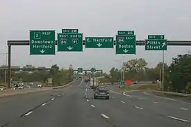
| East Hartford | 0.46– 0.98 | 0.74– 1.58 | 3 | 1A | Pitkin Street / East River Drive | No eastbound entrance; westbound exit currently not signed, but will be 1A; westbound exit signed as Darlin Street | |
| 0.88 | 1.42 | 2E | 1B/1D | Signed as Exit 2 eastbound; Exits 54-55 on I-84; westbound entrance includes access to Exit 3 | |||
| 2W | 1C | Westbound exit and eastbound entrance; Exit 55 on I-84 | |||||
| 1.35 | 2.17 | 4 | 1E | No eastbound exit; Exit 90 on US 5 / Route 15 / Wilbur Cross Highway | |||
| 1.80 | 2.90 | 5 | 2 | Riverside Drive / Willow Street (SR 516) | Eastbound exit and westbound entrance | ||
| 2.80– 3.04 | 4.51– 4.89 | 5A | 3A | High Street (eastbound) / Main Street (westbound) | SR 517; westbound signed as Exit 3 | ||
| 3.27 | 5.26 | 5B | 3B | Sutton Avenue | Eastbound exit and westbound entrance (Cambridge Drive) | ||
| 3.67 | 5.91 | 5C | 4A | Maple Street | No westbound exit | ||
| 4.41 | 7.10 | 5D | 4B | Northern terminus of Route 3; westbound signed as Exit 5 | |||
| Glastonbury | 4.70 | 7.56 | 6 | 4C | Griswold Street – Glastonbury | Eastbound exit and westbound entrance; no access from Exit 5D entrance ramp | |
| 5.07 | 8.16 | 7 | 5A | Eastbound exit and westbound entrance; northern terminus of Route 17 | |||
| 5.31– 6.01 | 8.55– 9.67 | 8 | 5B | Western terminus of Route 94; westbound signed as Exit 5 | |||
| 7.12 | 11.46 | 9 | 7 | Neipsic Road – Glastonbury | Eastbound exit and westbound entrance | ||
| 9.94 | 16.00 | 10 | 10 | Southern terminus of Route 83 | |||
| 11.56 | 18.60 | 11 | 11 | Thompson Street / Wassuc Road – Glastonbury | Westbound exit and eastbound entrance | ||
| Marlborough | 13.42 | 21.60 | 12 | 13 | West Road / Business Route – Marlborough | Eastbound exit and westbound entrance | |
| 15.44 | 24.85 | 13 | 15 | ||||
| 17.66 | 28.42 | 15 | 18 | South Main Street – Marlborough | Westbound exit and eastbound entrance | ||
| New London | Colchester | 20.38 | 32.80 | 16 | 20 | Northern terminus of Route 149 | |
| 22.37 | 36.00 | 17 | 22 | Business Route – Colchester | Eastbound exit and westbound entrance | ||
| 23.70 | 38.14 | 18 | 24A | Westbound exit signed as Exit 24 | |||
| 24.35 | 39.19 | 19 | 24B | Eastbound exit and westbound entrance; northern terminus of Route 11 | |||
| 25.05 | 40.31 | 20 | 25 | Westbound exit and eastbound entrance | |||
| 26.03– 26.47 | 41.89– 42.60 | 21 | 26 | Chestnut Hill Road (eastbound) / Business Route (westbound) – Colchester | SR 616 | ||
| Lebanon | 30.91 | 49.74 | 22 | 31 | Scott Hill Road – Gilman, Lebanon | ||
| Bozrah | 33.32 | 53.62 | 23 | 33 | Northern terminus of Route 163 | ||
| 34.54 | 55.59 | 24 | 35 | Fitchville Road (SR 608) – Fitchville | Westbound exit and eastbound entrance | ||
| Norwich | 35.62– 36.33 | 57.32– 58.47 | 25 | 36A | Western terminus of Route 32 west concurrency; access via SR 642; westbound exit and entrance | ||
| 27 | 36B | Western end of Route 32 east concurrency; Eastbound signed as Exit 36 | |||||
| - | – | Browning Road | Eastbound entrance only | ||||
| 37.00 | 59.55 | 28S | 37A | Northern terminus of Route 2A; Exits 13A-B on I-395; Westbound signed as Exit 37 | |||
| 28N | 37B | Eastbound exit and entrance | |||||
| 37.71 | 60.69 | 29 | 38 | New London Turnpike – Norwichtown | |||
| 38.15 | 61.40 | At-grade intersection; east end of freeway section | |||||
| 39.52 | 63.60 | Eastern end of Route 32 concurrency | |||||
| 39.88 | 64.18 | Western end of Route 12 concurrency | |||||
| 40.19 | 64.68 | Eastern end of Route 12 concurrency | |||||
| 40.52 | 65.21 | Western terminus of Route 165 | |||||
| Preston | 42.95 | 69.12 | |||||
| 45.70 | 73.55 | Southern terminus of Route 164 | |||||
| Ledyard | 47.27 | 76.07 | Foxwoods Boulevard / Fox Tower Drive / Lake of Isles Drive | Interchange | |||
| 48.20 | 77.57 | Interchange; eastern terminus of Route 214 | |||||
| North Stonington | 50.33 | 81.00 | Western end of Route 201 concurrency | ||||
| 51.11 | 82.25 | Eastern end of Route 201 concurrency | |||||
| 54.29 | 87.37 | ||||||
| 55.24 | 88.90 | Exit 92 on I-95; access from I-95 north and to I-95 south | |||||
| Stonington | 56.01 | 90.14 | Southern terminus of Route 49 | ||||
| 56.67 | 91.20 | Partial interchange; western terminus of Route 78 | |||||
| 58.03 | 93.39 | ||||||
1.000 mi = 1.609 km; 1.000 km = 0.621 mi
| |||||||
See also
- List of state highways in Connecticut
- List of highways numbered 2
References
- "Connecticut State Highway Log (2006)" (PDF). Archived from the original (PDF) on September 27, 2011. Retrieved March 11, 2009.
- F.J. Wood, The Turnpikes of New England, (Marshall Jones, 1919)
- nycroads.com - CT Route 2
External links
![]() Media related to Connecticut Route 2 at Wikimedia Commons
Media related to Connecticut Route 2 at Wikimedia Commons