Interstate 84 in Connecticut
Interstate 84 (I-84) is an east–west Interstate highway across the state of Connecticut through Danbury, Waterbury, Hartford and Union.
| ||||
|---|---|---|---|---|
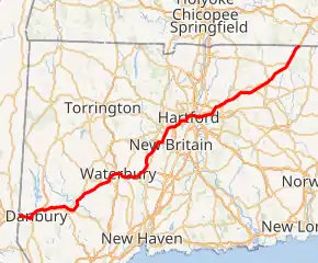
I-84 highlighted in red | ||||
| Route information | ||||
| Maintained by ConnDOT | ||||
| Length | 97.90 mi[1] (157.55 km) | |||
| Existed | 1969–present | |||
| Major junctions | ||||
| West end | ||||
| ||||
| East end | ||||
| Location | ||||
| Counties | Fairfield, New Haven, Hartford, Tolland, Windham | |||
| Highway system | ||||
| ||||

Route description
I-84 enters Danbury from the town of Southeast, New York, and is designated the Yankee Expressway for the next 62 miles (100 km). About 3.5 miles (5.6 km) to the east, US 7 joins from the south at exit 3 near Danbury Fair Mall as I-84 turns north. At the next exit, US 6 and 202 join to form a four-way concurrency for the next three miles (4.8 km) to exit 7, when US 7 and US 202 split off north towards New Milford. US 6 leaves the Interstate at the following exit, as I-84 climbs away from Danbury into the more rural towns of Bethel, and Brookfield.
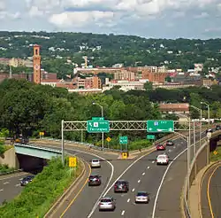
US 6 rejoins I-84 at exit 10, and at exit 11, it turns to the northeast and descends to cross the Housatonic River on the Rochambeau Bridge, into New Haven County. After US 6 leaves once again at exit 15 in Southbury, I-84 proceeds through hilly terrain into Middlebury, becoming more of an urban freeway as it enters the city of Waterbury, where it intersects the Route 8 expressway and crosses the Naugatuck River on an elevated dual-decked viaduct known locally as The Mixmaster. After passing through Cheshire, I-84 intersects the western end of I-691 at the Cheshire–Southington town line, which is also the New Haven–Hartford county line.
I-84 turns more northerly for a stretch to exit 31 (Route 229), which provides access to Lake Compounce Amusement Park and ESPN World Headquarters. The freeway heads more northeasterly to Plainville, where it has a brief 0.5-mile (0.80 km) concurrency with Route 72 to the New Britain city line. From the Route 72 junction through Farmington, West Hartford, and into Hartford, I-84 has many left-hand exits and entrances and sharp curves, which were built for a planned network of freeways. In Farmington, US 6 joins I-84 once again at exit 38, and both meet the northern end of the Route 9 expressway at a half-used multi-level stack interchange that was originally planned to be part of the mostly-cancelled I-291 Hartford Beltway. I-84 and US 6 pass through West Hartford into Hartford (the largest city along the length of the eastern I-84) where they intersect I-91, just before US 44 briefly joins to cross the Connecticut River into East Hartford on the Bulkeley Bridge, which is the oldest bridge on the Interstate system.
After the bridge, US 44 leaves, the name of the highway changes to the Lieutenant Brian L. Aselton Memorial Highway, and I-84 meets the Route 2 expressway, which provides access to the southeastern suburbs of Hartford. As I-84 passes the northern end of the Route 15 expressway, it inherits the Wilbur Cross Highway name for the rest of its length. From 1968 until 1984, the I-84 designation ended here, and the highway became I-86 for the rest of its length, as I-84 was once planned to be built east toward Providence, Rhode Island. I-84 intersects one of the remnants of the abandoned project, I-384, as part of a three-mile (4.8 km) series of complex interchanges in Manchester including the end of the US 6 concurrency at exit 60, and a connection to the only built as originally planned portion of I-291 at exit 61.
Beyond Manchester, I-84 climbs steadily from the Connecticut River Valley and passes through the Tolland County towns of Vernon, Tolland, and Willington. After briefly entering the Windham County town of Ashford, it reenters Tolland County in the town of Union. After exit 74 (Route 171), I-84 crosses the Massachusetts state line. All lanes eventually enter into Sturbridge, but the westbound lanes pass briefly through the town of Holland before entering Sturbridge. Eight miles (13 km) later, I-84 reaches its eastern terminus at the Massachusetts Turnpike (I-90).
History
1970s route
| |
|---|---|
| Location | East Hartford–Providence |
| Existed | 1956–1968 |
| History | Re-designated as I-84 in 1968 |
| |
|---|---|
| Location | East Hartford–Providence |
| Existed | 1968–1984 |
| History | Cancelled; completed sections re-designated as I-384 and US 6 in 1984 |
A highway connecting Hartford and Providence was first brought up in 1944 as an upgrade to US 6 from Manchester to the Rhode Island state line.[2][3] The plan eventually adapted to a submission to the 1956 Interstate Highway Plan, but was declined. It was re-submitted in the 1968 plan, and was granted along with 1,500 other miles of Interstate.[4]
The highway was firstly designated as Interstate 82, but was changed shortly after to its well-known designation, Interstate 84.[4] In 1970 through 1973 the first segments of the highway started construction, the segment now designated as I-384, and the Willimantic Bypass.[2] When these isolated segments were completed, they were designated for the future Interstate, starkly different from today's signs. The signs remained on the Willimantic Bypass up to a decade after the cancellation of the project.[5]
The planned I-84 was going to also incorporate a cloverleaf intersection with I-295 in Johnston, Rhode Island, and use the under-construction Dennis J. Roberts Expressway and built Huntington Expressway to Providence before the project was shelved.[6] Briefly, there was an idea to use the southern/unused portion of the highway for Interstate 184, but was disapproved by the FHA.[7]
An environmental study by RIDOT was done in 1972, it was found the highway would cause heavy impact to Scituate Reservoir, the drinking supply for Providence.[8] [9]After multiple other studies, Rhode Island ended up cancelling their segment of the highway in 1982, which ended up causing Connecticut to cut the segment to I-395 in Plainfield.[10] Without Rhode Island, the highway was fully canceled in 1983, and the mileage was returned for other projects.[11][12]
After the highway was canceled, the only inland route to Providence from Hartford was either US 44 or US 6. Many projects have since happened to improve the roads, mainly in Connecticut.[13][14] One major one was improving the "Suicide 6" area of US 6 between Bolton and Columbia.[15][16] Since the cancellation, other plans to have a freeway link between the two built segments have been proposed, including one in 2001, but was short lived, only lasting to 2003 before becoming dormant.[2][17]
Though the route was basically set in stone in Connecticut, many issues remained in Rhode Island, the biggest of which were major environmental concerns about how the freeway would affect the Scituate Reservoir, which is the main drinking water supply for Providence.
In the 1992 long-range transportation plan released by the Rhode Island Department of Transportation, a freeway has been added along the original route of Interstate 84 that will connect to the CT 695 freeway on the Rhode Island–Connecticut border.[18]
I-86 relation
| |
|---|---|
| Location | East Hartford–Union (MA state line) |
| Length | 31.27 mi (50.32 km) |
| Existed | 1968–1984 |
| History | Re-designated as I-84 in August 1984[19] |
The section of I-84 between East Hartford, Connecticut (at the present-day junction with Interstate 384) and Sturbridge, Massachusetts (Interstate 90) was for a time signed as Interstate 86 (unrelated to present-day Interstate 86 in New York and Pennsylvania). Signs stating "I-84 Ends, I-86 to Boston" (eastbound) and "I-86 Ends, I-84 to Hartford" (westbound) were posted where the change took place. Exit numbering on I-86 was that of the road's predecessor, Route 15, in a sequence beginning on New York's Hutchinson River Parkway. Exits were renumbered to correspond with the rest of I-84 in Connecticut when the road was redesignated in 1984. The present I-384 as well as the present US 6 bypass near Willimantic, both of which were a part of what was then I-84's planned easterly continuation, were also numbered I-84 prior to 1984 even though they lacked any direct connection to the rest of I-84 at that time. (One had to use Silver Lane in East Hartford to travel between the two stretches of the highway.) These two sections were re-numbered. The western segment became I-384, and the eastern one became part of US 6 when what was then I-86 was re-numbered I-84.[20]
Upgrades
Sections of I-84 in Connecticut were reconstructed and widened from the mid 1970s into the mid 1980s. Another section through Danbury was widened from 4 lanes to 6 lanes in 1985 and 1986. Widening of the highway through Danbury was funded by Union Carbide as part of building its world headquarters in Danbury.[21] From roughly 1976 to 1988 the former I-86 portion from East Hartford to the Massachusetts state line was completely rebuilt from a narrow 4-lane parkway to a much wider profile ranging from 6 lanes at the Massachusetts state line, expanding to 8 lanes in Vernon, to 12 lanes with HOV lanes in East Hartford. The original route, then known as Route 15, featured pit latrines at its pull offs or rest areas. As of 2014 planning is underway for the I-84 Hartford Project to replace and possibly redesign a two-mile stretch of mostly elevated highway in Hartford. On April 22, 2015, construction began on widening the highway from Exit 23 to Exit 25A in Waterbury from 4 lanes to 6 lanes.
A widening project along the congested stretch of I-84 through Waterbury and Cheshire, Connecticut has been beset by cost overruns, delays, and construction defects involving storm drains,[22] as state and federal officials have launched criminal investigations stemming from this project. This episode has waned local enthusiasm for a proposed $2 billion reconstruction of the Mixmaster interchange in downtown Waterbury.[23] Cost estimates for the Mixmaster replacement have increased to $3 billion.[24] CT Attorney General Richard Blumenthal has begun a lawsuit against the contractor and an engineering firm in response to threats from the U.S. DOT to withhold funds from the project.[25] On May 18, 2007, the Waterbury Republican-American reported this area had defective light poles,[26] while Governor M. Jodi Rell released an audit report of the construction disaster.[27] A number of DOT personnel were either fired or reprimanded following the scandal. Meanwhile the FBI and a federal grand jury are investigating the now-defunct construction company and the same DOT officials, which may eventually lead to criminal charges in the case.
Future
The I-84 Hartford Project[28] is a ConnDOT project to address structural deficiencies within the I-84 corridor approximately between Flatbush Avenue (exit 45) and the I-91 interchange in Hartford, including a 3,200-foot (980 m) elevated section known as the Aetna Viaduct. Since it became apparent in the 1980s that this section of I-84 in Hartford was deteriorating, ConnDOT has considered how best to repair or reconstruct the corridor. Since that time, many inspections have been carried out and frequent repairs made to keep the highway safe and functioning.[29]
In 2010, the Capitol Region Council of Governments (CRCOG), the City of Hartford, and ConnDOT collaborated on a study of the corridor to begin the process of exploring reconstruction options. That study looked at several concepts, including the rebuilding of the viaduct "in-kind", as well as several reconstruction alternatives that would alter the configuration of the highway. The alternatives developed for that study were conceptual in nature—they did not look in depth at traffic, engineering feasibility, or environmental impact. However, the strong stakeholder input as part of that effort was helpful in leading to CTDOT's decision to initiate The I-84 Hartford Project, to build on the good work of that earlier study. The I-84 Hartford Project will be a full and comprehensive evaluation leading to a workable solution. The I-84 Hartford Project will examine the feasibility and assess the impact of a range of concepts. Following full examination of the impacts and benefits of feasible alternatives, and, in collaboration with stakeholders and the public, ConnDOT will make a final decision on how to reconstruct this section of the I-84 corridor.[30][31]
Exit list
| County | Location | mi[1] | km | Exit | Destinations | Notes |
|---|---|---|---|---|---|---|
| Fairfield | Danbury | 0.00 | 0.00 | – | Continuation into New York; to I-684 | |
| 0.04– 0.44 | 0.064– 0.71 | 1 | Saw Mill Road | Eastbound exit and westbound entrance extend into New York | ||
| 0.78– 1.36 | 1.26– 2.19 | 2 | Signed as exits 2A (Old Ridgebury) and 2B (US 6/US 202) westbound | |||
| – | Rest Area/Welcome Center | Shared ramp with exit 2; eastbound exit and entrance | ||||
| 3.24– 3.70 | 5.21– 5.95 | 3 | Western terminus of US 7 concurrency; also serves Danbury Airport | |||
| 3.76 | 6.05 | 4 | Western terminus of US 6/US 202 concurrency | |||
| 5.27 | 8.48 | 5 | Route 37 only appears on eastbound signage | |||
| 5.84 | 9.40 | 6 | Westbound exit and eastbound entrance | |||
| 7.34– 7.77 | 11.81– 12.50 | 7 | Eastern terminus of US 7/US 202 concurrency | |||
| Danbury–Bethel line | 8.17– 8.79 | 13.15– 14.15 | 8 | Eastern terminus of US 6 concurrency; no westbound signage for US 6 | ||
| Brookfield–Newtown line | 11.44 | 18.41 | 9 | Signed for Hawleyville | ||
| Newtown | 15.12 | 24.33 | 10 | Western terminus of US 6 concurrency; | ||
| 16.14– 16.64 | 25.97– 26.78 | 11 | Access via SSR 490 | |||
| Housatonic River | 18.48 | 29.74 | Rochambeau Bridge | |||
| New Haven | Southbury | 18.74 | 30.16 | 13 | River Road | Eastbound exit and westbound entrance |
| 20.21 | 32.52 | 14 | ||||
| 22.00 | 35.41 | 15 | Eastern terminus of US 6 concurrency | |||
| 24.80 | 39.91 | 16 | No westbound signage for Middlebury | |||
| Middlebury–Waterbury line | 29.81 | 47.97 | 17 | Eastbound exit and westbound entrance | ||
| 30.48 | 49.05 | Westbound exit and eastbound entrance | ||||
| Waterbury | 31.35 | 50.45 | 18 | Chase Parkway | Eastbound exit and westbound entrance | |
| 31.65 | 50.94 | West Main Street/Highland Avenue | Westbound exit and eastbound entrance | |||
| 32.02 | 51.53 | 19 | Mixmaster Interchange; exits 31 and 33 on Route 8 | |||
| 20 | ||||||
| 32.45– 32.76 | 52.22– 52.72 | 21 | Meadow Street/Bank Street | |||
| 32.60– 33.56 | 52.46– 54.01 | 22 | Baldwin Street/Union Street – Downtown Waterbury | Signed eastbound for Baldwin Street, westbound for Union Street | ||
| 33.02– 34.21 | 53.14– 55.06 | 23 | Eastbound access via separate exits, on collector-distributor road | |||
| 34.36 | 55.30 | 25 | Harpers Ferry Road/Reidville Drive | Eastbound exit and westbound entrance | ||
| 35.62 | 57.32 | East Main Street/Scott Road | Westbound exit and eastbound entrance | |||
| 36.73 | 59.11 | 25A | Austin Road | Serves University of Bridgeport | ||
| Cheshire | 38.12 | 61.35 | 26 | No eastbound signage for Prospect | ||
| 40.04– 41.04 | 64.44– 66.05 | 27 | Western terminus of I-691 | |||
| Hartford | Southington | 40.68 | 65.47 | 28 | ||
| 41.89 | 67.42 | 29 | Westbound left exit and eastbound entrance; via SR 597 | |||
| 42.52 | 68.43 | 30 | West Main Street/Marion Avenue | Signed eastbound for Downtown Southington/ Plainsville | ||
| 44.34 | 71.36 | 31 | Lake Compounce Amusement Park and ESPN World Headquarters | |||
| 46.23 | 74.40 | 32 | Signed westbound for Downtown Southington | |||
| Plainville | 48.98 | 78.83 | 33 | Eastbound exit and westbound entrance; exit 4 on Route 72 | ||
| 49.41 | 79.52 | 34 | Westbound exit is via exit 33 | |||
| 49.48 | 79.63 | 33 | Western terminus of Route 72 concurrency; westbound exit and eastbound entrance | |||
| New Britain | 50.00– 50.61 | 80.47– 81.45 | 35 | Eastern terminus of Route 72 concurrency | ||
| 50.65– 51.19 | 81.51– 82.38 | 36 | Slater Road | Left exit eastbound. | ||
| Farmington | 53.24 | 85.68 | 37 | Fienemann Road | Eastbound exit signed for US 6 west | |
| 54.04 | 86.97 | 38 | Western terminus of US 6 concurrency; westbound exit and eastbound entrance | |||
| 54.35 | 87.47 | 39 | Access via SR 508 | |||
| 54.99– 56.00 | 88.50– 90.12 | 39A | Northern terminus of Route 9 | |||
| West Hartford | 56.27 | 90.56 | 40 | |||
| 57.23 | 92.10 | 41 | South Main Street - Elmwood | |||
| 58.05 | 93.42 | 42 | Trout Brook Drive - Elmwood | Westbound exit and eastbound entrance | ||
| 57.95– 58.40 | 93.26– 93.99 | 43 | Park Road – West Hartford Center | Access via SR 501 | ||
| 59.17 | 95.22 | 44 | Prospect Avenue/Oakwood Avenue | Access via Caya Avenue eastbound, Kane Street westbound | ||
| Hartford | 59.93 | 96.45 | 45 | Flatbush Avenue | Westbound exit and eastbound entrance; via SR 504 | |
| 60.45– 60.79 | 97.28– 97.83 | 46 | Sisson Avenue/West Boulevard | Access via SR 503; part of once planned Route 9 (later Route 189) expressway | ||
| 61.04 | 98.23 | 47 | Sigourney Street | Westbound exit and eastbound entrance | ||
| 61.38– 61.77 | 98.78– 99.41 | 48B | Asylum Street | Signed as exit 48 westbound | ||
| 48A | Capitol Avenue | Eastbound exit and westbound entrance | ||||
| 61.99 | 99.76 | 49 | Chapel Street/High Street/Ann Uccello Street | Eastbound exit and westbound entrance,Ann Uccello Street signed only | ||
| 62.04 | 99.84 | 50 | Main Street | Eastbound exit and westbound entrance | ||
| 62.13– 62.63 | 99.99– 100.79 | 51 | Exits 32B (west) and 30 (east) on I-91 south | |||
| 62.51 | 100.60 | 52 | Westbound access is via exit 50 | |||
| 62.60 | 100.74 | 50 | Western terminus of US 44 concurrency; westbound exit and eastbound entrance | |||
| Connecticut River | 62.58– 62.82 | 100.71– 101.10 | Bulkeley Bridge | |||
| East Hartford | 62.95 | 101.31 | 53 | Eastern terminus of US 44 concurrency; no westbound exit | ||
| 63.37 | 101.98 | 54 | Westbound exit and eastbound entrance; western terminus of westbound HOV lanes | |||
| 63.18– 63.49 | 101.68– 102.18 | 55 | ||||
| 63.37– 63.63 | 101.98– 102.40 | 56 | Governor Street – Downtown East Hartford | Access via SR 500 | ||
| – | Westbound entrance only | |||||
| — | Restricted Lanes – Buses and 2 person car pools | Western terminus of eastbound HOV lanes | ||||
| 64.84 | 104.35 | 57 | Westbound exit and eastbound entrance | |||
| 64.64– 65.21 | 104.03– 104.95 | — | Silver Lane | HOV access only; westbound exit and eastbound entrance | ||
| 58 | Roberts Street (SR 518)/Silver Lane (SR 502)/Burnside Avenue | |||||
| 66.43– 68.61 | 106.91– 110.42 | 59 | Western terminus of I-384; Silver Lane/Spencer Street (I-384 exit 1) not signed eastbound | |||
| — | HOV access only; eastbound exit and westbound entrance | |||||
| Manchester | 68.05 | 109.52 | 60 | Eastern terminus of US 6 concurrency; westbound exit shares a ramp with exit 62 | ||
| 68.17– 69.03 | 109.71– 111.09 | 61 | Eastern terminus of I-291 | |||
| 69.84 | 112.40 | 62 | Buckland Street | Westbound access via Pleasant Valley Road | ||
| — | Buckland Street | HOV access only; eastbound exit and westbound entrance | ||||
| 71.60 | 115.23 | 63 | ||||
| Tolland | Vernon | 73.00 | 117.48 | 64 | Eastbound exit shares a ramp with exit 65 | |
| — | HOV access only; eastbound exit and westbound entrance | |||||
| 73.27 | 117.92 | Eastern terminus of HOV lanes | ||||
| 73.00– 73.93 | 117.48– 118.98 | 65 | ||||
| 74.80 | 120.38 | 66 | Tunnel Road – Vernon, Bolton | |||
| 77.28 | 124.37 | 67 | ||||
| Tolland | 81.06 | 130.45 | 68 | Serves University of Connecticut | ||
| 83.99 | 135.17 | 69 | ||||
| Willington | 85.58 | 137.73 | 70 | |||
| 87.79 | 141.28 | 71 | ||||
| Windham–Tolland county line | Ashford–Union line | 92.05 | 148.14 | 72 | ||
| Tolland | Union | 93.41 | 150.33 | 73 | ||
| 97.38 | 156.72 | 74 | ||||
| 97.90 | 157.55 | – | Continuation into Massachusetts; to Mass Pike | |||
1.000 mi = 1.609 km; 1.000 km = 0.621 mi
| ||||||
Auxiliary routes
| Interstate | City | Type | Notes | |
|---|---|---|---|---|
| Interstate 384 | Manchester | Spur | ||
| Interstate 484 | Hartford | Bypass route | Unfinished and decommissioned. Partially exists as the Conlin–Whitehead Highway | |
| Interstate 684 | Greenwich | Bypass route | This route extends for 1.4 miles (2.25 km) in Connecticut, with all interchanges in New York; originally designated as I-87 |
References
- Roadway Inventory Section (December 31, 2014). Highway Log: Connecticut State Numbered Routes and Roads (PDF). Connecticut Department of Transportation. Archived from the original (PDF) on July 26, 2015. Retrieved August 21, 2016.
- Oglesby, Scott. "From Hartford to Providence". www.kurumi.com. Retrieved November 15, 2016.
- "Road Plan Urged for Connecticut; Highway Department Favors $400,000,000 Long-Range System of Expressways". The New York Times. March 31, 1953. ISSN 0362-4331. Retrieved November 16, 2016.
- "Dennis J Roberts Expressway (US 6)". www.bostonroads.com. Retrieved November 15, 2016.
- Oglesby, Scott. "Connecticut I-384". www.kurumi.com. Retrieved November 15, 2016.
- I-84 Extension from I-295 to the Connecticut State Line: Environmental Impact Statement. 1972.
- "Huntington Expressway (RI 10 and US 6)". www.bostonroads.com. Retrieved November 16, 2016.
- "677 F.2d 259". law.resource.org. Retrieved November 16, 2016.
- I-84 Extension from I-295 to the Connecticut State Line: Environmental Impact Statement. 1972.
- Wald, Matthew L. (October 16, 1979). "Goldschmidt Says I‐84 to Proceed In Connecticut, but He Is Doubted". The New York Times. ISSN 0362-4331. Retrieved November 16, 2016.
- I-84, Section 2 Corridor Location Between Windham and Rhode Island State Line: Environmental Impact Statement. 1976.
- I-84, Section 1, Corridor Location Between Manchester and Columbia: Environmental Impact Statement. 1976.
- US-6 Improvements, Killingly, CT to Johnston, RI: Environmental Impact Statement. 1985.
- "Army Corps Considers Route 6". Hartford Courant. Retrieved November 16, 2016.
- "Report: Connecticut Has Nation's Deadliest Rural Roads". Hartford Courant. Retrieved November 15, 2016.
- "Getting Ready To Start Route 6 Project". Hartford Courant. Retrieved November 16, 2016.
- "MTR 258, Third Time as Farce: ConnDOT Tries Again for Twice-rejected Road -". www.tstc.org. Archived from the original on May 12, 2016. Retrieved November 16, 2016.
- Anderson, Steve. "Dennis J Robers Expressway (US 6)". BostonRoads.com.
- "State Changes Route Designation". The North Adams Transcript. North Adams, Massachusetts. August 15, 1984. p. 3. Retrieved September 14, 2019 – via Newspapers.com.

- Oglesby, Scott. "Connecticut I-86". www.kurumi.com. Retrieved November 15, 2016.
- "Do You Remember?". Danbury News-Times. September 4, 2005.
- "Storm Drains". News Times. Retrieved December 30, 2017.
- "Interchange Construction Planned: For 2021". Hartford, CT: WFSB-TV. September 25, 2006. Archived from the original on September 27, 2007. Retrieved April 16, 2011.
- "Topic Galleries". Hartford Courant. Archived from the original on January 21, 2013. Retrieved April 16, 2011.
- "Light poles". News Times. Retrieved December 30, 2017.
- Cooper, Chris (May 28, 2007). "Governor Rell: I-84 Consultant Releases Final Audit Report" (Press release). Office of the Governor. Retrieved April 16, 2011.
- "I-84 Hartford Project".
- "Aetna Viaduct". Courant.com. Retrieved December 30, 2017.
- Hyman, Dylan (September 8, 2016). "I-84 Hartford viaduct project moving forward". New Haven, CT: WTNH-TV. Retrieved September 11, 2016.
- "DOT: No Tunnel For New I-84 In Hartford". Hartford Courant. Retrieved September 11, 2016.
External links
| Wikimedia Commons has media related to Interstate 84 in Connecticut. |
| Previous state: New York |
Connecticut | Next state: Massachusetts |