East Hartford, Connecticut
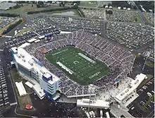
East Hartford is a town in Hartford County, Connecticut, United States. The population was 51,252 at the 2010 census. The town is located on the east bank of the Connecticut River, directly across from Hartford, Connecticut.[1] It is home to aerospace manufacturer Pratt & Whitney. It is also home to Pratt & Whitney Stadium at Rentschler Field, a stadium used mainly for soccer and football with a capacity of 40,000 people.
East Hartford, Connecticut | |
|---|---|
Town | |
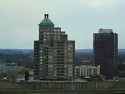 The skyline near the Connecticut River | |
 Flag  Seal | |
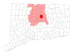 Location in Hartford County, Connecticut | |
 East Hartford Location in the contiguous United States and Connecticut  East Hartford East Hartford (Connecticut) | |
| Coordinates: 41°45′41″N 72°36′55″W | |
| Country | |
| U.S. state | |
| County | Hartford |
| Metropolitan area | Hartford |
| Incorporated | 1783 |
| Government | |
| • Type | Mayor-council |
| • Mayor | Marcia Leclerc (D) |
| • for places with, say, both a mayor and a city manager | Town Council
Rich Kehoe Chairman Don Bell Vice Chairman Sebrina Wilson Majority Leader Esther Clakre Minority Leader Connor Martin Awet Tsegai Angie Parkinson John Morrison Patricia Harmon |
| Area | |
| • Total | 18.7 sq mi (48.5 km2) |
| • Land | 18.0 sq mi (46.6 km2) |
| • Water | 0.7 sq mi (1.9 km2) |
| Elevation | 39 ft (12 m) |
| Population (2010)[1] | |
| • Total | 51,252 |
| • Density | 2,740.7/sq mi (1,058.2/km2) |
| Time zone | UTC-5 (Eastern) |
| • Summer (DST) | UTC-4 (Eastern) |
| ZIP code | 06108, 06118 |
| Area code(s) | 860 |
| FIPS code | 09-22630 |
| GNIS feature ID | 0213424 |
| Interstates | |
| U.S. Highways | |
| State Routes | |
| Website | www |
History
When the Connecticut Valley became known to Europeans around 1631, it was inhabited by what were known as the River Tribes — a number of small clans of Native Americans living along the Great River and its tributaries. Of these tribes the Podunks occupied territory now lying in the towns of East Hartford and South Windsor, and numbered, by differing estimates, from sixty to two hundred bowmen. They were governed by two sachems, Waginacut and Arramamet, and were connected in some way with the Native Americans who lived across the Great River, in what is now Windsor. The region north of the Hockanum River was generally called Podunk; that south of the river, Hockanum; but these were no certain designations, and by some all the meadow along the Great River was called Hockanum.[2]
In 1659, Thomas Burnham (1617–1688) purchased the tract of land now covered by the towns of South Windsor and East Hartford from Tantinomo, chief sachem of the Podunk Indians.[2] Burnham lived on the land and later willed it to his nine children.[3] The town of Hartford, founded in 1635, once included the land now occupied by the towns of East Hartford, Manchester, Bolton, Vernon, and West Hartford. During the Revolutionary War, French troops under Lieutenant General Comte de Rochambeau twice camped in town, before and after aiding General George Washington's forces in the 1781 defeat of the British during the Siege of Yorktown.[4]
East Hartford was incorporated as a separate town in October 1783. Manchester separated from East Hartford in 1823.[2] Beginning in the late nineteenth century, residents began to form tax districts for fire protection, street lighting, sanitation, and other public works improvements. The East Hartford Fire District was granted a charter by the General Assembly in 1889 and organized in June, 1891. The Meadow Fire District existed before the turn of the twentieth century. The Hockanum Sewer District and Hockanum Lighting District were formed in 1915 and 1916 respectively. The Silver Lane Fire and Lighting District was founded in 1925. On June 10, 1929, voters of the town approved a new charter. All of the old districts were abolished and a Town Council would govern the municipality.[5]
Since first being settled, East Hartford's economy was primarily agricultural, with tobacco being the main crop. All that changed in 1929, when Frederick Rentschler, head of the new Pratt and Whitney Aircraft Company, moved production from Hartford to a sprawling 1,100 acre (445 ha) site in East Hartford. The grounds included a small airport called Rentschler Field that was in service from 1931 to 1999. It was originally used for test flights and maintenance operations, and later for corporate aviation.[6] The 75-acre (30 ha) site was decommissioned as an airport in the 1990s, and donated to the state of Connecticut by United Technologies in 1999, and a new Rentschler Field opened as a stadium with capacity of 40,000 people. Pursuant to a lease agreement with the State, UConn plays all its home football games at Rentschler Field.On July 16, 2015, it was announced that the stadium had been named Pratt & Whitney Stadium at Rentschler Field in a deal between Pratt & Whitney and UConn. The playing surface is still named Rentschler Field.[7]
Geography
The town is located on the east bank of the Connecticut River, directly across from Hartford, Connecticut. The town includes the neighborhoods of Burnside Hockanum, and Mayberry Village. According to the United States Census Bureau, the town has a total area of 18.7 square miles (48.5 km2), of which 18.0 square miles (46.6 km2) is land and 0.73 square miles (1.9 km2), or 3.93%, is water.[1]
Demographics
As of [8] 2010, there were 51,252 people, 20,206 households, and 12,830 families residing in the town. The population density was 3,200 people per square mile (1,250/km2). There were 21,328 housing units at an average density of 1,180.2 per square mile (455.8/km2). The racial makeup of the town was 38.4% non-Hispanic White, 25.9% Black or African American, 0.03% Native American, 5.9% Asian, 0.04% Pacific Islander, 0.3% from other races, and 1.9% from two or more races. Hispanic or Latino of any race were 28.3% of the population. The town has seen significant demographic changes in recent decades due to immigration from Hartford, as well as white residents leaving the city to other suburbs.[9]
There were 20,206 households, out of which 29.2% had children under the age of 18 living with them, 41.5% were married couples living together, 17.4% had a female householder with no husband present, and 36.5% were non-families. 30.2% of all households were made up of individuals, and 11.3% had someone living alone who was 65 years of age or older. The average household size was 2.42 and the average family size was 3.01.
In the town, the population was spread out, with 24.1% under the age of 18, 7.8% from 18 to 24, 30.2% from 25 to 44, 22.3% from 45 to 64, and 15.6% who were 65 years of age or older. The median age was 37 years. For every 100 females, there were 91.4 males. For every 100 females age 18 and over, there were 87.8 males.
The median income for a household in the town was $41,424, and the median income for a family was $50,540. Males had a median income of $36,823 versus $29,860 for females. The per capita income for the town was $21,763. About 8.1% of families and 10.3% of the population were below the poverty line, including 15.5% of those under age 18 and 7.3% of those age 65 or over.
Government and politics
.jpg.webp)
East Hartford has a mayor–council government. Marcia Leclerc was sworn in as Mayor of the Town of East Hartford on January 10, 2011.[10] Leclerc is a Democrat, and was reelected to her fifth term in 2019.[11]
| Year | Democratic | Republican | Third Parties |
|---|---|---|---|
| 2016 | 69.20% 13,180 | 27.37% 5,213 | 3.43% 654 |
| 2012 | 75.04% 14,149 | 24.16% 4,556 | 0.80% 150 |
| 2008 | 73.19% 14,811 | 25.67% 5,195 | 1.14% 230 |
| 2004 | 64.25% 11,996 | 33.86% 6,322 | 1.90% 354 |
| 2000 | 67.12% 12,371 | 27.80% 5,124 | 5.08% 936 |
| 1996 | 62.84% 11,904 | 23.89% 4,525 | 13.27% 2,514 |
| 1992 | 48.70% 11,450 | 27.53% 6,472 | 23.78% 5,590 |
| 1988 | 58.98% 12,511 | 40.07% 8,501 | 0.95% 201 |
| 1984 | 47.78% 10,647 | 51.64% 11,508 | 0.58% 129 |
| 1980 | 49.30% 11,416 | 36.65% 8,487 | 14.05% 3,254 |
| 1976 | 57.57% 14,052 | 41.70% 10,178 | 0.73% 179 |
| 1972 | 50.61% 13,057 | 48.12% 12,414 | 1.27% 327 |
| 1968 | 60.03% 14,349 | 33.20% 7,935 | 6.78% 1,620 |
| 1964 | 77.07% 16,605 | 22.93% 4,940 | 0.00% 0 |
| 1960 | 62.53% 12,971 | 37.47% 7,771 | 0.00% 0 |
| 1956 | 44.52% 8,266 | 55.48% 10,303 | 0.00% 0 |
| Voter Registration and Party Enrollment as of October 30, 2007[13] | |||||
|---|---|---|---|---|---|
| Party | Active Voters | Inactive Voters | Total Voters | Percentage | |
| Democratic | 11,321 | 1,088 | 12,409 | 45.82% | |
| Republican | 2,820 | 305 | 3,125 | 11.54% | |
| Unaffiliated | 10,087 | 1,420 | 11,507 | 42.48% | |
| Minor Parties | 38 | 6 | 44 | 0.16% | |
| Total | 24,266 | 2,819 | 27,085 | 100% | |
| Historical population | |||
|---|---|---|---|
| Census | Pop. | %± | |
| 1820 | 3,375 | — | |
| 1850 | 2,497 | — | |
| 1860 | 2,951 | 18.2% | |
| 1870 | 3,007 | 1.9% | |
| 1880 | 3,500 | 16.4% | |
| 1890 | 4,455 | 27.3% | |
| 1900 | 6,406 | 43.8% | |
| 1910 | 8,138 | 27.0% | |
| 1920 | 11,648 | 43.1% | |
| 1930 | 17,125 | 47.0% | |
| 1940 | 18,615 | 8.7% | |
| 1950 | 29,933 | 60.8% | |
| 1960 | 43,977 | 46.9% | |
| 1970 | 57,583 | 30.9% | |
| 1980 | 52,563 | −8.7% | |
| 1990 | 50,452 | −4.0% | |
| 2000 | 49,575 | −1.7% | |
| 2010 | 51,252 | 3.4% | |
Economy
East Hartford is home to the headquarters of Pratt & Whitney,[14] part of the United Technologies conglomerate. The manufacturing plant takes up a significant amount of East Hartford's area, and at its peak, it employed tens of thousands of people; [15] however, currently, it only employs about 7,621.[16] East Hartford also contains a Coca-Cola bottling plant, located on Main Street. The city is dotted with industrial and suburban office parks, and in the early 2000s, urban planners strategically situated a regional stadium, Rentschler Stadium (construction completed September 2003), and a hunting and camping focused department store, Cabela's, on the then vacant former Pratt & Whitney company airfield, Rentschler Field.[17]
Top employers
According to East Hartford's Comprehensive Annual Financial Report,[18] the top employers in the city are:
| # | Employer | # of Employees |
|---|---|---|
| 1 | Pratt and Whitney | 9,000 |
| 2 | Town of East Hartford | 1,698 |
| 3 | Goodwin University | 720 |
| 4 | Coca-Cola Refreshments | 600 |
| 5 | Bank of America | 550 |
| 6 | United Technologies Corporation Research Center | 515 |
| 7 | Riverside Health and Rehabilitation Center | 438 |
| 8 | Connecticut Bureau of Enterprise Systems and Technology | 397 |
| 9 | Cabela's | 326 |
| 10 | DXC Technology | 297 |
| 11 | Connecticut Natural Gas | 263 |
| 12 | Red Thread, a subsidiary of Steelcase | 175 |
| 13 | Connecticut Judicial Branch | 130 |
| 14 | United Steel | 127 |
| 15 | Clearwater Paper | 98 |
Education
Attractions
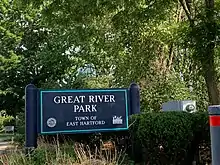
The Great River Park is located on the banks of the Connecticut River in East Hartford, providing riverside activities for the town.[19]
Wickham Park, located in East Hartford and Manchester, features Oriental gardens, fountains, open fields, woodlands, ponds, picnic areas, softball fields, and an aviary. The west side of the park offers a scenic view of East Hartford and the skyline of Hartford across the Connecticut River and is a popular site for weddings. It also has a very popular sledding hill in the winter.[20]
Nearby, Rentschler Field Stadium is home of the University of Connecticut Huskies football team.[21]
Notable people
- Milton Avery, artist
- Lawrence Brainerd, businessman, abolitionist and United States senator from Vermont
- Mary Cadorette, actress
- Samuel Colt, founder of Colt Firearms
- Howard Ensign Evans, noted entomologist
- Francis Patrick Garvan, lawyer and longtime president of the Chemical Foundation
- John A. Gurley, U.S. Representative from Ohio during the early part of the American Civil War
- John Larson, current U.S. Representative from Connecticut's 1st congressional district
- Hiram N. Moulton, mayor of Madison, Wisconsin
- Aaron Olmsted, sea captain, namesake of several cities in Ohio
- Denison Olmsted, physicist and astronomer
- Frederick Law Olmsted, renowned urban and suburban planner famous for many of the New York City parks and Stanford University's campus lived and studied for much of his youth between his primary residence in Hartford and his father's childhood home in East Hartford.
- Gérard Ouellet, member of the Canadian House of Commons
- Charles Phelps, first Connecticut Attorney General
- Diane Venora, actress
References
- "Geographic Identifiers: 2010 Demographic Profile Data (G001): East Hartford town, Hartford County, Connecticut". U.S. Census Bureau, American Factfinder. Archived from the original on February 12, 2020. Retrieved November 26, 2012.
- Goodwin, Joseph Olcott (1879). East Hartford: Its History and Traditions. Hartford, Connecticut: Case, Lockwood, and Brainard Co.
- Burnham, Roderick Henry (1869). The Burnham Family; Or Genealogical Records of the Descendants of the Four. Hartford, Connecticut: Case, Lockwood, and Brainard Co.
- "East Hartford". ConnecticutHistory.org. Retrieved 6 September 2019.
- Paquette, Lee (1976). Only More So: The History of East Hartford, 1783-1976. East Hartford, CT: Raymond Library Company. pp. 142, 205, 209.
- "May 24, 1931: 'Original' Rentschler Field Dedicated". United Technologies. Retrieved 7 September 2019.
- Rent Being Renamed Pratt & Whitney Stadium At Rentschler Field
- "U.S. Census website". United States Census Bureau. Retrieved September 1, 2015.
- "East Hartford, CT Population - Census 2010 and 2000 Interactive Map, Demographics, Statistics, Quick Facts - CensusViewer". censusviewer.com. Retrieved 2020-09-13.
- Carlson, Suzanne (9 November 2015). "East Hartford Mayor Marcia Leclerc Sworn In To Third Term". Hartford Courant. Retrieved 7 September 2019.
- Leavenworth, Jesse (5 November 2019). "Mayor and fellow Democrats retain control of town council in East Hartford". courant.com. Hartford Courant. Retrieved 14 April 2020.
- https://authoring.ct.gov//SOTS/Election-Services/Statement-Of-Vote-PDFs/General-Elections-Statement-of-Vote-1922
- "Registration and Party Enrollment Statistics as of October 30, 2007" (PDF). Connecticut Secretary of State. Archived from the original (PDF) on February 1, 2015. Retrieved 2008-09-18.
- "Contact Us Archived 2011-03-19 at the Wayback Machine." Pratt & Whitney. Retrieved on January 7, 2011. "Corporate Headquarters Pratt & Whitney 400 Main Street East Hartford, CT 06108."
- Chen, Xiangming and John Shemo. 2013. “Shifting Fortunes: Hartford’s Global and Regional Economic Dimensions.” Pp. 193-218 in Confronting Urban Legacy: Rediscovering Hartford and New England's Forgotten Cities. Xiangming Chen and Nick Bacon (eds). Lanham, MD: Lexington Books.
- Town of East Hartford CAFR Archived 2013-07-24 at the Wayback Machine
- Bacon, Nick. 2013. “Podunk after Pratt: Place and Placelessness in East Hartford, CT.” Pp. 46-64 in Confronting Urban Legacy: Rediscovering Hartford and New England's Forgotten Cities. Xiangming Chen and Nick Bacon (eds). Lanham, MD: Lexington Books.
- Town of East Hartford Annual Reports
- "Great River Park | Riverfront Recapture". www.riverfront.org. Retrieved 2017-05-22.
- "Wickham Park, Manchester Connecticut". www.wickhampark.org. Retrieved 2017-05-22.
- "UCONNHUSKIES.COM :: University of Connecticut Huskies Official Athletic Site". www.uconnhuskies.com. Retrieved 2017-05-22.
External links
| Wikimedia Commons has media related to East Hartford, Connecticut. |

Municipalities and communities of Hartford County, Connecticut, United States | ||
|---|---|---|
| Cities |  | |
| Towns | ||
| CDPs | ||
| Other communities | ||
| ||
| Authority control |
|---|