Connecticut Route 541
State Road 541 (SR 541, also known as South Frontage Road and Bolton Road) is a 0.82-mile-long (1.32 km) unsigned highway in the US state of Connecticut. The road is contained inside the town of Vernon. It runs from Route 533 to Route 30.
| State Road 541 | |
|---|---|
| |
| Route information | |
| Maintained by ConnDOT | |
| Length | 0.82 mi[1] (1.32 km) |
| Existed | 1977–present |
| Major junctions | |
| South end | SR 533 in Vernon, Connecticut |
| North end | |
| Location | |
| Counties | Tolland |
| Highway system | |
| |
Route description
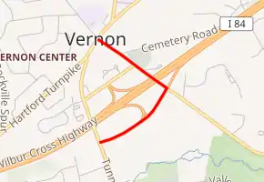
Route 541 begins at Route 533 in the central portion of the town of Vernon, known as South Frontage Road. It then runs 0.2 miles (0.32 km) in a northeasterly direction before it intersects with the eastbound off-ramp for exit 66 on Interstate 84 (I-84). It then travels another 0.2 miles (0.32 km) northeastward before it intersects with Bolton Road. The route then turns north on Bolton Road. Across from the intersection lies the eastbound on-ramp for exit 66. Route 541 continues north, passing under I-84 and intersecting with Route 542. From the Route 542 intersection, the road continues north for another 0.2 miles (0.32 km) before the road intersects with Route 30 and ends.[2]
History
In 1977, South Frontage Road and Bolton Road were given a highway designation, with many other roads in Vernon. It was given the designation of SR 541.
Major intersections
The entire route is in Vernon, Tolland County.
| mi[1] | km | Destinations | Notes | ||
|---|---|---|---|---|---|
| 0.00 | 0.00 | SR 533 (Tunnel Road) | Southern terminus | ||
| 0.22– 0.42 | 0.35– 0.68 | Exit 66 (I-84) | |||
| 0.62 | 1.00 | Eastern terminus of SR 542 | |||
| 0.82 | 1.32 | Northern terminus | |||
| 1.000 mi = 1.609 km; 1.000 km = 0.621 mi | |||||
See also
 U.S. Roads portal
 Connecticut portal
References
- Connecticut Department of Transportation (December 31, 2014). "Highway Log" (PDF). Connecticut Department of Transportation. Archived from the original (PDF) on July 26, 2015.
- Google (January 4, 2020). "Connecticut Route 541" (Map). Google Maps. Google. Retrieved January 4, 2020.