Copper River Census Area, Alaska
Copper River Census Area is a census area located in the state of Alaska, United States. It is part of the Unorganized Borough and therefore has no borough seat. On January 2, 2019, it was split from the Valdez–Cordova Census Area, along with neighboring Chugach Census Area.
Copper River Census Area | |
|---|---|
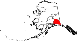 Location within the U.S. state of Alaska | |
.svg.png.webp) Alaska's location within the U.S. | |
| Coordinates: 62°02′N 143°55′W | |
| Country | |
| State | |
| Founded | January 2, 2019[1] |
| Largest city | Glennallen |
| Area | |
| • Total | 24,692 sq mi (63,950 km2) |
| Population (2010) | |
| • Total | 2,952 |
| • Density | 0.12/sq mi (0.05/km2) |
| Time zone | UTC−9 (Alaska) |
| • Summer (DST) | UTC−8 (ADT) |
| Congressional district | At-large |
Demographics
According to the 2010 United States Census (in which it was reported as the "Copper River Census Subarea"), the census area had a population of 2,952; 2,229 (75.5%) of whom were over the age of 18, and 321 (10.9%) of whom were over the age of 65. 2,032 residents (68.8%) were reported as White alone (2,020/68.4% non-Hispanic white), 11 (0.4%) as Black, 678 (23.0%) as American Indian or Alaska Native, 11 (0.4%) as Asian, 13 (0.4%) as Native Hawaiian or other Pacific Islander, 5 (0.2%) as some other race, and 202 (6.9%) as two or more races. 53 people (1.8%) were Hispanic or Latino (they may be of any of the above racial categories).[2]
See also
References
- In 2019, the United States Census Bureau divided the Valdez–Cordova Census Area into Chugach and Copper River.
- "Alaska: 2010 Summary Population and Housing Characteristics" (pdf). United States Census Bureau. June 2012. Retrieved November 26, 2020.