County of Tambo, Victoria
The County of Tambo is one of the 37 counties of Victoria which are part of the cadastral divisions of Australia, used for land titles. It is located in eastern Gippsland, between the Tambo River in the west, and the Snowy River in the east. It includes Lakes Entrance. Some time earlier maps showed proposed counties of Abinger and Combermere occupying the area.
| Tambo Victoria | |||||||||||||||
|---|---|---|---|---|---|---|---|---|---|---|---|---|---|---|---|
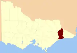 Location in Victoria | |||||||||||||||
| Established | 24 February 1871 | ||||||||||||||
| Area | 5,091 km2 (1,965.6 sq mi) | ||||||||||||||
| |||||||||||||||
Parishes
Parishes include:
- Berrmarr, Victoria
- Bete Bolong North, Victoria
- Bete Bolong South, Victoria
- Bindi, Victoria
- Buchan, Victoria
- Chilpin, Victoria
- Colquhoun, Victoria
- Colquhoun East, Victoria
- Colquhoun North, Victoria
- Detarka, Victoria
- Ensay, Victoria
- Eucambene, Victoria
- Eumana, Victoria
- Forest Hill, Victoria
- Gelantipy East, Victoria
- Gelantipy West, Victoria
- Gillingal, Victoria
- Glenmore, Victoria
- Ingeegoobee, Victoria
- Kaerwut, Victoria
- Karawah, Victoria
- Maneroo, Victoria
- Marroo, Victoria
- Mellick-Munjie, Victoria
- Menaak, Victoria
- Murrindal East, Victoria
- Murrindal West, Victoria
- Nappa, Victoria
- Newmerella, Victoria
- Ninnie, Victoria
- Nowa Nowa, Victoria
- Nowa Nowa South, Victoria
- Noyong, Victoria
- Numbie-Munjie, Victoria
- Tildesley East, Victoria
- Tildesley West, Victoria
- Timbarra, Victoria
- Tongio-Munjie East, Victoria
- Toonginbooka, Victoria
- Waygara, Victoria
- Windarra, Victoria
- Woongulmerang East, Victoria
- Woongulmerang West, Victoria
References
- Vicnames, place name details
- Research aids, Victoria 1910
- Cadastral map showing county and parish boundaries, categories of land holdings and reserves. 1880s, National Library of Australia
This article is issued from Wikipedia. The text is licensed under Creative Commons - Attribution - Sharealike. Additional terms may apply for the media files.