Courval, Saskatchewan
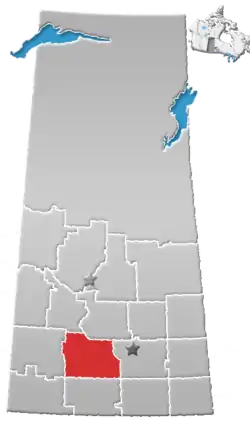
Courval is an unincorporated community in the Rural Municipality of Rodgers No. 133 in the Canadian province of Saskatchewan. Recognized as a designated place by Statistics Canada, Courval had a population of 5 in the Canada 2006 Census.[4]
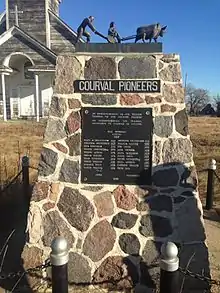
Commemorative marker for the pioneers of Courval in 1906
Courval | |
|---|---|
Unincorporated community | |
 Courval | |
 Courval Location of Courval in Saskatchewan  Courval Courval (Canada) | |
| Coordinates: 50°09′30″N 106°15′18″W | |
| Country | Canada |
| Province | Saskatchewan |
| Rural Municipality | Rodgers No. 133 |
| Area | |
| • Land | 0.14 km2 (0.05 sq mi) |
| Population (2011)[1] | |
| • Total | 5 |
| • Density | 35.1/km2 (91/sq mi) |
| Time zone | UTC-6 (Central) |
| Area code(s) | 306 |
| [2][3] | |
Demographics
| Canada census – Courval, Saskatchewan community profile | |||
|---|---|---|---|
| 2011 | |||
| Population: | 5 (0.0% from 2006) | ||
| Land area: | 0.14 km2 (0.054 sq mi) | ||
| Population density: | 35.1/km2 (91/sq mi) | ||
| Median age: | |||
| Total private dwellings: | 2 | ||
| Median household income: | |||
| References: 2011[5] earlier[6] | |||
Climate
| Climate data for Courval | |||||||||||||
|---|---|---|---|---|---|---|---|---|---|---|---|---|---|
| Month | Jan | Feb | Mar | Apr | May | Jun | Jul | Aug | Sep | Oct | Nov | Dec | Year |
| Record high °C (°F) | 7 (45) |
15 (59) |
20.5 (68.9) |
29 (84) |
37 (99) |
41 (106) |
38.5 (101.3) |
39.5 (103.1) |
36 (97) |
33 (91) |
21 (70) |
10.5 (50.9) |
41 (106) |
| Average high °C (°F) | −7.8 (18.0) |
−5 (23) |
2.6 (36.7) |
12.3 (54.1) |
19.1 (66.4) |
23.4 (74.1) |
26.1 (79.0) |
26 (79) |
19 (66) |
11.6 (52.9) |
0.8 (33.4) |
−6.9 (19.6) |
10.1 (50.2) |
| Daily mean °C (°F) | −12.9 (8.8) |
−10.3 (13.5) |
−2.5 (27.5) |
5.3 (41.5) |
11.9 (53.4) |
16.4 (61.5) |
18.7 (65.7) |
18.3 (64.9) |
11.8 (53.2) |
5 (41) |
−4.2 (24.4) |
−12.1 (10.2) |
3.8 (38.8) |
| Average low °C (°F) | −18.1 (−0.6) |
−15.5 (4.1) |
−7.6 (18.3) |
−1.7 (28.9) |
4.7 (40.5) |
9.3 (48.7) |
11.2 (52.2) |
10.6 (51.1) |
4.6 (40.3) |
−1.6 (29.1) |
−9.1 (15.6) |
−17.3 (0.9) |
−2.5 (27.5) |
| Record low °C (°F) | −41 (−42) |
−41 (−42) |
−32.5 (−26.5) |
−21 (−6) |
−9 (16) |
−3.5 (25.7) |
2.5 (36.5) |
−0.5 (31.1) |
−8.5 (16.7) |
−23.5 (−10.3) |
−33 (−27) |
−43 (−45) |
−43 (−45) |
| Average precipitation mm (inches) | 13 (0.5) |
12.8 (0.50) |
19.3 (0.76) |
21.1 (0.83) |
50.6 (1.99) |
65.5 (2.58) |
54.4 (2.14) |
41.8 (1.65) |
35 (1.4) |
19.2 (0.76) |
13 (0.5) |
17.2 (0.68) |
372.8 (14.68) |
| Source: Environment Canada[7] | |||||||||||||
References
- "2011 Community Profiles". Statistics Canada. Government of Canada. Retrieved 21 August 2014.
- National Archives, Archivia Net. "Post Offices and Postmasters". Archived from the original on 6 October 2006. Retrieved 21 August 2014.
- Government of Saskatchewan, MRD Home. "Municipal Directory System". Archived from the original on 15 January 2016. Retrieved 21 August 2014.
- Canada 2006 Census: Designated places in Saskatchewan
- "2011 Community Profiles". 2011 Canadian Census. Statistics Canada. 5 July 2013.
- "2001 Community Profiles". 2001 Canadian Census. Statistics Canada. 17 February 2012.
- Environment Canada Canadian Climate Normals 1971–2000, accessed 24 July 2010
This article is issued from Wikipedia. The text is licensed under Creative Commons - Attribution - Sharealike. Additional terms may apply for the media files.