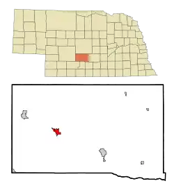
Cozad, Nebraska
Cozad is a city in Dawson County, Nebraska, United States. The population was 3,977 at the 2010 census. The town is on the Great Plains of central Nebraska, along the Union Pacific Railroad and U.S. Route 30, just north of the Platte River. The 100th meridian, which roughly marks the eastward boundary of the arid plains, passes just west of the town as is marked nearby on a prominent sign across U.S. 30. In the early 1860s, the meridian was a stop along the Pony Express.
Cozad, Nebraska | |
|---|---|
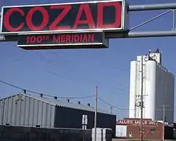 Sign marking the 100th meridian on U.S. Highway 30 in Cozad | |
 Location of Cozad, Nebraska | |
| Coordinates: 40°51′44″N 99°59′3″W | |
| Country | United States |
| State | Nebraska |
| County | Dawson |
| Area | |
| • Total | 2.62 sq mi (6.77 km2) |
| • Land | 2.62 sq mi (6.77 km2) |
| • Water | 0.00 sq mi (0.00 km2) |
| Elevation | 2,490 ft (759 m) |
| Population | |
| • Total | 3,977 |
| • Estimate (2019)[3] | 3,735 |
| • Density | 1,427.75/sq mi (551.29/km2) |
| Time zone | UTC-6 (Central (CST)) |
| • Summer (DST) | UTC-5 (CDT) |
| ZIP code | 69130 |
| Area code(s) | 308 |
| FIPS code | 31-11020 |
| GNIS feature ID | 0828431[4] |
| Website | cozadnebraska.net |
History
Cozad was founded in 1873 by John J. Cozad, a native of Ohio, and father of painter Robert Henri. He purchased 40,000 acres of land from the Union Pacific Railroad and laid out the future town. He built houses on some of the land to entice people to settle. He sold off most of the land to future residents[5] who named the town after him.[6][7] Cozad also founded Cozaddale, Ohio, a small, unincorporated village 25 miles northeast of Cincinnati.[8]
The nursing home in Cozad was one of the few nursing homes that remained open in 2019 in this area of Nebraska.[9]
Geography
Cozad is located at 40°51′44″N 99°59′3″W (40.862141, -99.984082).[10]
According to the United States Census Bureau, the city has a total area of 2.62 square miles (6.79 km2), all land.[11]
Demographics
| Historical population | |||
|---|---|---|---|
| Census | Pop. | %± | |
| 1890 | 542 | — | |
| 1900 | 739 | 36.3% | |
| 1910 | 1,096 | 48.3% | |
| 1920 | 1,293 | 18.0% | |
| 1930 | 1,813 | 40.2% | |
| 1940 | 2,156 | 18.9% | |
| 1950 | 2,910 | 35.0% | |
| 1960 | 3,184 | 9.4% | |
| 1970 | 4,225 | 32.7% | |
| 1980 | 4,453 | 5.4% | |
| 1990 | 3,823 | −14.1% | |
| 2000 | 4,163 | 8.9% | |
| 2010 | 3,977 | −4.5% | |
| 2019 (est.) | 3,735 | [3] | −6.1% |
| U.S. Decennial Census[12] 2012 Estimate[13] | |||
Cozad is part of the Lexington, Nebraska Micropolitan Statistical Area.
2010 census
At the 2010 census there were 3,977 people in 1,656 households, including 1,058 families, in the city. The population density was 1,517.9 inhabitants per square mile (586.1/km2). There were 1,881 housing units at an average density of 717.9 per square mile (277.2/km2). The racial makeup of the city was 92.4% White, 0.4% African American, 0.4% Native American, 0.3% Asian, 5.2% from other races, and 1.3% from two or more races. Hispanic or Latino of any race were 13.3%.[2]
Of the 1,656 households 33.1% had children under the age of 18 living with them, 47.8% were married couples living together, 10.3% had a female householder with no husband present, 5.9% had a male householder with no wife present, and 36.1% were non-families. 31.6% of households were one person and 15.4% were one person aged 65 or older. The average household size was 2.35 and the average family size was 2.92.
The median age was 39.3 years. 26.2% of residents were under the age of 18; 7% were between the ages of 18 and 24; 24% were from 25 to 44; 24.9% were from 45 to 64; and 17.8% were 65 or older. The gender makeup of the city was 48.5% male and 51.5% female.
2000 census
At the 2000 census, there were 4,163 people in 1,722 households, including 1,127 families, in the city. The population density was 2,007.2 people per square mile (776.5/km2). There were 1,851 housing units at an average density of 892.5 per square mile (345.3/km2). The racial makeup of the city was 93.39% White, 0.17% African American, 0.43% Native American, 0.43% Asian, 3.82% from other races, and 1.75% from two or more races. Hispanic or Latino of any race were 10.95% of the population.
Of the 1,722 households 32.0% had children under the age of 18 living with them, 52.6% were married couples living together, 8.9% had a female householder with no husband present, and 34.5% were non-families. 30.4% of households were one person and 14.7% were one person aged 65 or older. The average household size was 2.37 and the average family size was 2.95.
The age distribution was 26.4% under the age of 18, 7.8% from 18 to 24, 27.0% from 25 to 44, 22.2% from 45 to 64, and 16.6% 65 or older. The median age was 37 years. For every 100 females, there were 92.8 males. For every 100 females age 18 and over, there were 90.8 males.
The median household income was $32,392, and the median family income was $43,413. Males had a median income of $27,217 versus $20,089 for females. The per capita income for the city was $18,139. About 9.8% of families and 12.1% of the population were below the poverty line, including 17.1% of those under age 18 and 11.3% of those age 65 or over.
Government
Cozad uses an elected mayor and a city council consisting of four council members, with the city clerk handling day-to-day operations. The city also has a seven-member police department with centralized dispatch out of the county sheriff's office in Lexington.[14]
Notable people
- Heather Armbrust, IFBB professional bodybuilder, was born in Cozad
- Dan Christensen, American abstract painter, was born in Cozad
- Jared Crick, NFL defensive end
- Kirstin Cronn-Mills, young adult author
- Chris Dishman, NFL lineman
- Robert Henri, American painter of the Ashcan School, was the son of John J. Cozad. His boyhood home the Robert Henri Museum is open to the public in the summer months.
References
- "2019 U.S. Gazetteer Files". United States Census Bureau. Retrieved July 26, 2020.
- "U.S. Census website". United States Census Bureau. Retrieved 2012-06-24.
- "Population and Housing Unit Estimates". United States Census Bureau. May 24, 2020. Retrieved May 27, 2020.
- "US Board on Geographic Names". United States Geological Survey. 2007-10-25. Retrieved 2008-01-31.
- Bowman, J. R. (1882). Shearer, Frederick E. (ed.). The Pacific tourist. J.R. Bowman's illustrated transcontinental guide of travel from the Atlantic to the Pacific Ocean. New York: J.R. Bowman. p. 38. OCLC 752667534. Retrieved 15 May 2018.
- Fitzpatrick, Lillian L. (1960). Nebraska Place-Names. University of Nebraska Press. ISBN 0803250606. A 1925 edition is available for download at University of Nebraska—Lincoln Digital Commons.
- "Cozad, Dawson County". Center for Advanced Land Management Information Technologies. University of Nebraska. Retrieved 4 August 2014.
- The History of Warren County, Ohio: Containing a History of the County ; Its Townships, Towns. W.H. Beers & Company. 1882. p. 618.
- Saslow, Eli (2019-12-21). "Traveling the loneliest road". The Washington Post. Archived from the original on 2019-12-22. Retrieved 2019-12-22.
- "US Gazetteer files: 2010, 2000, and 1990". United States Census Bureau. 2011-02-12. Retrieved 2011-04-23.
- "US Gazetteer files 2010". United States Census Bureau. Archived from the original on January 12, 2012. Retrieved 2012-06-24.
- United States Census Bureau. "Census of Population and Housing". Retrieved October 18, 2013.
- "Annual Estimates of the Resident Population: April 1, 2010 to July 1, 2012". Archived from the original on June 2, 2013. Retrieved October 18, 2013.
- "CITY OF COZAD". cozadnebraska.net. Retrieved February 21, 2020.
External links
Municipalities and communities of Dawson County, Nebraska, United States | ||
|---|---|---|
| Cities | Map of Nebraska highlighting Dawson County | |
| Villages | ||
| CDP | ||
| Unincorporated communities | ||
| Former communities | ||
| ||
