List of counties in Nebraska
The following is a list of the 93 counties in the U.S. state of Nebraska, listed by name, FIPS code and license plate prefix.
| Counties of Nebraska | |
|---|---|
| |
| Location | State of Nebraska |
| Number | 93 |
| Populations | 458 (Arthur) – 537,256 (Douglas) |
| Areas | 241 square miles (620 km2) (Sarpy) – 5,961 square miles (15,440 km2) (Cherry) |
| Government | County government |
| Subdivisions | cities, towns, townships, unincorporated communities, Indian reservations, census designated place |
Nebraska's postal abbreviation is NE and its FIPS state code is 31.
When many counties were formed, the bills establishing them did not state the honoree's full name; thus the namesakes of several counties, including Brown, Deuel, Dixon, and possibly Harlan, are known only by their surnames.
County list
| County |
FIPS code[1] | County seat[2] | Est.[2] | Origin | Etymology | License plate prefix [3] |
Population[2] | Area[2] | Map |
|---|---|---|---|---|---|---|---|---|---|
| Adams County | 001 | Hastings | 1867 | Unorganized territory | John Adams, second President of the United States | 14 | 31,610 | 563 sq mi (1,458 km2) | 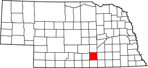 |
| Antelope County | 003 | Neligh | 1871 | Unorganized territory | Pronghorn, often called antelope | 26 | 6,456 | 857 sq mi (2,220 km2) | 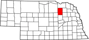 |
| Arthur County | 005 | Arthur | 1913 | Unorganized territory | Chester A. Arthur, twenty-first president of the United States | 91 | 458 | 715 sq mi (1,852 km2) | 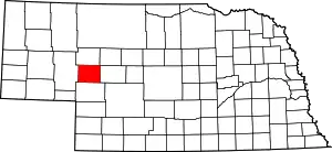 |
| Banner County | 007 | Harrisburg | 1888 | Formed from Cheyenne County | Early settlers' goal of making it the "banner county" of the state | 85 | 759 | 746 sq mi (1,932 km2) | 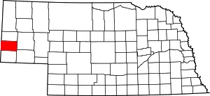 |
| Blaine County | 009 | Brewster | 1885 | Unorganized territory | James G. Blaine, national politician | 86 | 482 | 711 sq mi (1,841 km2) | 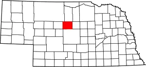 |
| Boone County | 011 | Albion | 1871 | Unorganized territory | Daniel Boone, American pioneer and trapper | 23 | 5,388 | 687 sq mi (1,779 km2) | 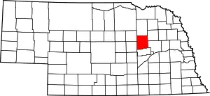 |
| Box Butte County | 013 | Alliance | 1887 | Formed from Dawes County | A box-shaped butte north of Alliance | 65 | 11,305 | 1,075 sq mi (2,784 km2) | 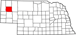 |
| Boyd County | 015 | Butte | 1891 | Holt County and unorganized territory (Indian Territory) | James E. Boyd, the eighth governor of Nebraska | 63 | 2,032 | 540 sq mi (1,399 km2) | 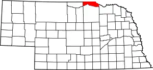 |
| Brown County | 017 | Ainsworth | 1883 | Unorganized territory | The Brown family of early settlers | 75 | 2,926 | 1,221 sq mi (3,162 km2) | 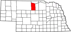 |
| Buffalo County | 019 | Kearney | 1855 | Unorganized territory | The American Bison | 9 | 47,893 | 968 sq mi (2,507 km2) | 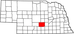 |
| Burt County | 021 | Tekamah | 1854 | One of nine original counties | Francis Burt, the first territorial governor | 31 | 6,574 | 493 sq mi (1,277 km2) | 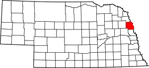 |
| Butler County | 023 | David City | 1856 | Formed from Greene County | William O. Butler, U.S. Congressman and military leader | 25 | 8,312 | 584 sq mi (1,513 km2) | 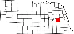 |
| Cass County | 025 | Plattsmouth | 1854 | One of nine original counties | Lewis Cass, the territorial administrator | 20 | 25,357 | 559 sq mi (1,448 km2) | 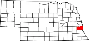 |
| Cedar County | 027 | Hartington | 1857 | Formed from Dixon and Pierce Counties | The eastern red cedar[4] | 13 | 8,711 | 740 sq mi (1,917 km2) | 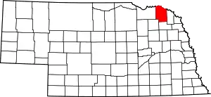 |
| Chase County | 029 | Imperial | 1873 | Unorganized territory | Champion S. Chase, Nebraska's first attorney general | 72 | 4,000 | 894 sq mi (2,315 km2) | 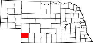 |
| Cherry County | 031 | Valentine | 1883 | Unorganized territory | Samuel A. Cherry, army lieutenant killed in the Indian Wars | 66 | 5,788 | 5,961 sq mi (15,439 km2) | 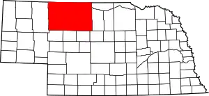 |
| Cheyenne County | 033 | Sidney | 1867 | Unorganized territory | Named for the Cheyenne Indian tribe | 39 | 10,091 | 1,196 sq mi (3,098 km2) | 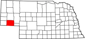 |
| Clay County | 035 | Clay Center | 1855 | Formed from unorganized territory | Henry Clay, national politician | 30 | 6,392 | 573 sq mi (1,484 km2) | 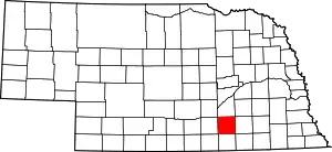 |
| Colfax County | 037 | Schuyler | 1869 | Formed from Platte County | Schuyler Colfax, Vice President of the United States | 43 | 10,425 | 413 sq mi (1,070 km2) | 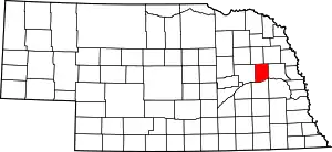 |
| Cuming County | 039 | West Point | 1855 | Formed from Burt County | Thomas B. Cuming, first territorial secretary | 24 | 8,996 | 572 sq mi (1,481 km2) | 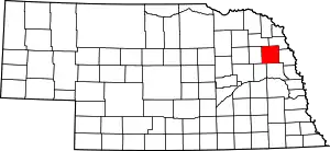 |
| Custer County | 041 | Broken Bow | 1877 | Unorganized territory | George Armstrong Custer, U.S. Army general | 4 | 10,792 | 2,576 sq mi (6,672 km2) | 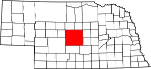 |
| Dakota County | 043 | Dakota City | 1855 | Formed from Burt County | Dakota branch of the Sioux Indian tribe | 70 | 20,947 | 264 sq mi (684 km2) | 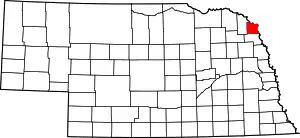 |
| Dawes County | 045 | Chadron | 1885 | Formed from Sioux County | James W. Dawes, the sixth governor of Nebraska | 69 | 9,088 | 1,396 sq mi (3,616 km2) | 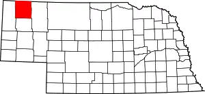 |
| Dawson County | 047 | Lexington | 1860 | Unorganized territory | Jacob Dawson, first postmaster for Lincoln | 18 | 24,207 | 1,013 sq mi (2,624 km2) | 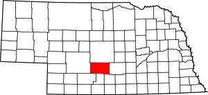 |
| Deuel County | 049 | Chappell | 1888 | Formed from Cheyenne County | The Deuel family of early settlers | 78 | 1,937 | 440 sq mi (1,140 km2) | 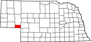 |
| Dixon County | 051 | Ponca | 1856 | Formed from Blackbird County, Izard County, and unorganized territory | The Dixon family of early settlers | 35 | 5,851 | 476 sq mi (1,233 km2) | 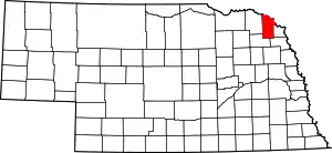 |
| Dodge County | 053 | Fremont | 1854 | One of nine original counties | Augustus Caesar Dodge, U.S. Senator who supported the Kansas-Nebraska Act | 5 | 36,515 | 534 sq mi (1,383 km2) | 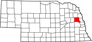 |
| Douglas County | 055 | Omaha | 1854 | One of nine original counties | Stephen Arnold Douglas, national politician | 1 | 537,256 | 331 sq mi (857 km2) | 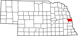 |
| Dundy County | 057 | Benkelman | 1873 | Unorganized territory | Elmer Scipio Dundy, U.S. Circuit Court judge | 76 | 1,981 | 920 sq mi (2,383 km2) | 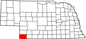 |
| Fillmore County | 059 | Geneva | 1856 | Formed from Jackson County and unorganized territory | Millard Fillmore, thirteenth president of the United States | 34 | 5,698 | 576 sq mi (1,492 km2) | 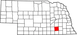 |
| Franklin County | 061 | Franklin | 1867 | Formed from Kearney County | Benjamin Franklin, Founding Father | 50 | 3,085 | 576 sq mi (1,492 km2) | 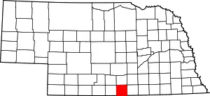 |
| Frontier County | 063 | Stockville | 1872 | Unorganized territory | Its location | 60 | 2,709 | 975 sq mi (2,525 km2) | 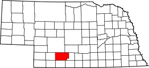 |
| Furnas County | 065 | Beaver City | 1873 | Unorganized territory | Robert Wilkinson Furnas, third governor of Nebraska | 38 | 4,865 | 718 sq mi (1,860 km2) | 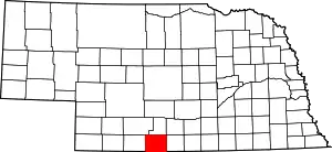 |
| Gage County | 067 | Beatrice | 1855 | Unorganized territory | William D. Gage, contemporary chaplain of the state legislature | 3 | 21,864 | 855 sq mi (2,214 km2) | 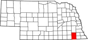 |
| Garden County | 069 | Oshkosh | 1910 | Formed from Deuel County | Early settlers' hopes for it to become the "garden spot of the west" | 77 | 1,902 | 1,705 sq mi (4,416 km2) | 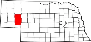 |
| Garfield County | 071 | Burwell | 1884 | Formed from Wheeler County | James Abram Garfield, twentieth president of the United States | 83 | 2,035 | 570 sq mi (1,476 km2) | 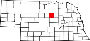 |
| Gosper County | 073 | Elwood | 1873 | Unorganized territory | John J. Gosper, contemporary Nebraska secretary of state | 73 | 1,972 | 458 sq mi (1,186 km2) | 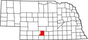 |
| Grant County | 075 | Hyannis | 1887 | Unorganized territory | Ulysses S. Grant, eighteenth president of the United States | 92 | 633 | 776 sq mi (2,010 km2) | 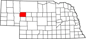 |
| Greeley County | 077 | Greeley | 1871 | Unorganized territory | Horace Greeley, journalist | 62 | 2,494 | 570 sq mi (1,476 km2) | 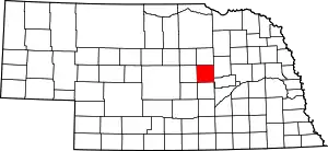 |
| Hall County | 079 | Grand Island | 1858 | Unorganized territory | Augustus Hall, contemporary chief justice of the Territorial Supreme Court | 8 | 60,720 | 546 sq mi (1,414 km2) | 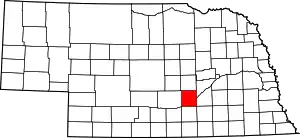 |
| Hamilton County | 081 | Aurora | 1867 | Unorganized territory | Alexander Hamilton, first United States Secretary of the Treasury | 28 | 9,112 | 544 sq mi (1,409 km2) | 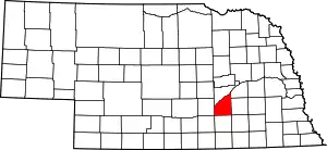 |
| Harlan County | 083 | Alma | 1871 | Formed from Kearney County | Disputed; either James Harlan, national politician, or a local revenue collector | 51 | 3,513 | 553 sq mi (1,432 km2) | 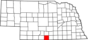 |
| Hayes County | 085 | Hayes Center | 1877 | Unorganized territory | Rutherford B. Hayes, nineteenth president of the United States | 79 | 976 | 713 sq mi (1,847 km2) | 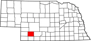 |
| Hitchcock County | 087 | Trenton | 1873 | Unorganized territory | Phineas Warren Hitchcock, Nebraska U.S. Senator | 67 | 2,872 | 710 sq mi (1,839 km2) | 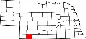 |
| Holt County | 089 | O'Neill | 1860 | Unorganized territory | Joseph Holt, U.S. Postmaster General and Secretary of War | 36 | 10,449 | 2,413 sq mi (6,250 km2) | 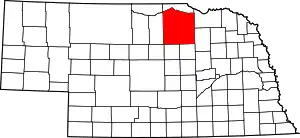 |
| Hooker County | 091 | Mullen | 1889 | Unorganized territory | Joseph Hooker, U.S. Army general | 93 | 738 | 721 sq mi (1,867 km2) | 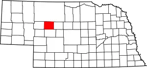 |
| Howard County | 093 | Saint Paul | 1871 | Formed from Hall County | Oliver O. Howard, U.S. Army general | 49 | 6,355 | 570 sq mi (1,476 km2) | 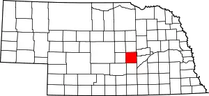 |
| Jefferson County | 095 | Fairbury | 1856 | Unorganized territory | Thomas Jefferson, the third president of the United States | 33 | 7,560 | 573 sq mi (1,484 km2) | 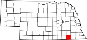 |
| Johnson County | 097 | Tecumseh | 1857 | Formed from Nemaha and Otoe Counties | Richard Mentor Johnson, ninth vice president of the United States | 57 | 5,144 | 376 sq mi (974 km2) | 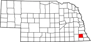 |
| Kearney County | 099 | Minden | 1860 | Unorganized territory | Fort Kearny, with a misspelling | 52 | 6,548 | 516 sq mi (1,336 km2) | 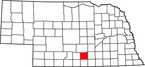 |
| Keith County | 101 | Ogallala | 1873 | Unorganized territory | M.C. Keith, rancher with wide holdings | 68 | 8,130 | 1,061 sq mi (2,748 km2) | 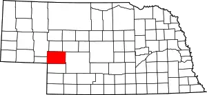 |
| Keya Paha County | 103 | Springview | 1884 | Formed from Brown County and unorganized Indian territory | Dakota words Ké-ya Pa-há Wa-kpá (turtle hill river) | 82 | 790 | 773 sq mi (2,002 km2) | 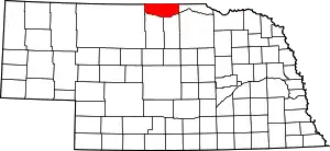 |
| Kimball County | 105 | Kimball | 1888 | Formed from Cheyenne County | Thomas L. Kimball, Union Pacific Railroad official | 71 | 3,702 | 952 sq mi (2,466 km2) | 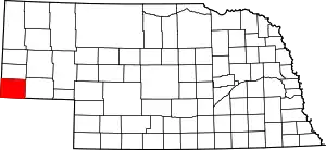 |
| Knox County | 107 | Center | 1857 | Formed from Pierce County and unorganized territory (Former names-L'Eau Qui Court (1857-1867) and Emmet (1867-1873)) | Henry Knox, first U.S. Secretary of War | 12 | 8,565 | 1,108 sq mi (2,870 km2) | 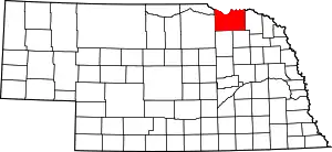 |
| Lancaster County | 109 | Lincoln | 1855 | Formed from Cass and Pierce Counties | Lancaster, Pennsylvania and Lancaster, England | 2 | 297,036 | 839 sq mi (2,173 km2) | 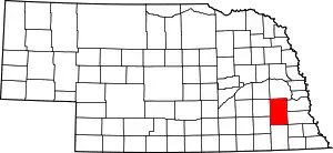 |
| Lincoln County | 111 | North Platte | 1860 | Unorganized territory | Abraham Lincoln, sixteenth president of the United States | 15 | 36,051 | 2,564 sq mi (6,641 km2) | 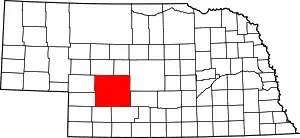 |
| Logan County | 113 | Stapleton | 1885 | Unorganized territory | John A. Logan, U.S. Army general | 87 | 763 | 571 sq mi (1,479 km2) | 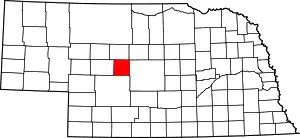 |
| Loup County | 115 | Taylor | 1883 | Unorganized territory | Loup River | 88 | 576 | 570 sq mi (1,476 km2) | 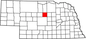 |
| Madison County | 119 | Madison | 1856 | Formed from Loup County, and McNeale County, and unorganized territory | Either James Madison, fourth president of the United States, or local settlers' native Madison, Wisconsin | 7 | 35,278 | 573 sq mi (1,484 km2) | 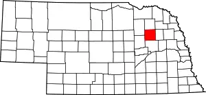 |
| McPherson County | 117 | Tryon | 1887 | Unorganized territory | James B. McPherson, U.S. Army general | 90 | 526 | 859 sq mi (2,225 km2) | 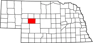 |
| Merrick County | 121 | Central City | 1858 | Formed from Polk County and unorganized territory | Elvira Merrick, wife of legislator Henry W. DePuy | 46 | 7,802 | 485 sq mi (1,256 km2) | 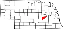 |
| Morrill County | 123 | Bridgeport | 1908 | Formed from Cheyenne County | Charles Henry Morrill, president of the Lincoln Land Company | 64 | 4,908 | 1,424 sq mi (3,688 km2) | 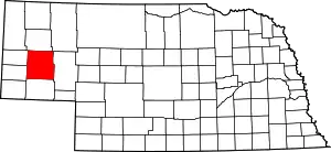 |
| Nance County | 125 | Fullerton | 1879 | Formed from a Pawnee Indian reservation | Albinus Nance, fourth governor of Nebraska | 58 | 3,623 | 441 sq mi (1,142 km2) | 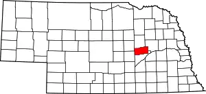 |
| Nemaha County | 127 | Auburn | 1854 | One of nine original counties | Nimaha, the Otoe name meaning miry water for a local stream | 44 | 7,157 | 409 sq mi (1,059 km2) | 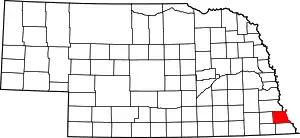 |
| Nuckolls County | 129 | Nelson | 1860 | Unorganized territory | Lafayette Nuckolls, a member of the first Nebraska territorial legislature; and his brother, Stephen Nuckolls, a pioneering Nebraska settler, businessman and banker | 42 | 4,413 | 575 sq mi (1,489 km2) | 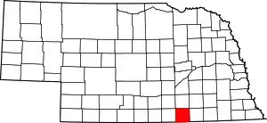 |
| Otoe County | 131 | Nebraska City | 1854 | One of nine original counties | Oto (also Otoe) Native American tribe | 11 | 15,752 | 616 sq mi (1,595 km2) | 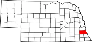 |
| Pawnee County | 133 | Pawnee City | 1855 | Formed from Richardson County | Pawnee Native American tribe | 54 | 2,709 | 432 sq mi (1,119 km2) | 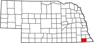 |
| Perkins County | 135 | Grant | 1887 | Formed from Keith County | Charles E. Perkins, a president of the Chicago, Burlington and Quincy Railroad | 74 | 2,921 | 883 sq mi (2,287 km2) | 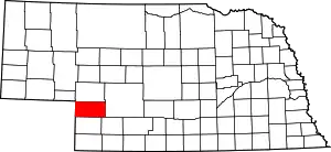 |
| Phelps County | 137 | Holdrege | 1873 | Formed from Kearney County | William Phelps, an early settler[4] | 37 | 9,213 | 540 sq mi (1,399 km2) | 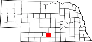 |
| Pierce County | 139 | Pierce | 1856 | Formed from Izard County, McNeale County, and unorganized territory | Franklin Pierce, the fourteenth president of the United States | 40 | 7,510 | 574 sq mi (1,487 km2) | 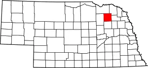 |
| Platte County | 141 | Columbus | 1856 | Formed from Greene and Loup Counties | Platte River which is in turn named for the French word for flat | 10 | 32,505 | 678 sq mi (1,756 km2) | 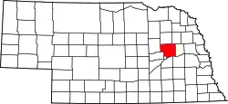 |
| Polk County | 143 | Osceola | 1856 | Formed from York County and unorganized territory | James Knox Polk, the eleventh president of the United States | 41 | 5,275 | 439 sq mi (1,137 km2) | 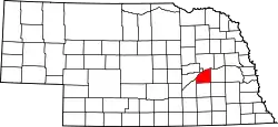 |
| Red Willow County | 145 | McCook | 1873 | Unorganized territory | Red Willow Creek, which runs through the area | 48 | 11,006 | 717 sq mi (1,857 km2) | 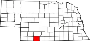 |
| Richardson County | 147 | Falls City | 1854 | One of nine original counties | William A. Richardson, a governor of the Nebraska Territory | 19 | 8,125 | 554 sq mi (1,435 km2) | 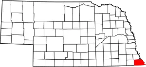 |
| Rock County | 149 | Bassett | 1885 | Formed from Brown County | Either Rock Creek, which flows in the county; or the rocky condition of the soil in the area | 81 | 1,411 | 1,008 sq mi (2,611 km2) | 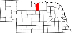 |
| Saline County | 151 | Wilber | 1867 | Unorganized territory | Named for a belief held by the early pioneers that great salt springs and deposits could be found in the area, a hope found to be false | 22 | 14,416 | 575 sq mi (1,489 km2) | 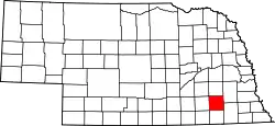 |
| Sarpy County | 153 | Papillion | 1857 | Formed from Cass and Douglas Counties | Peter A. Sarpy, a commander of a trading post in the future county | 59 | 169,331 | 241 sq mi (624 km2) | 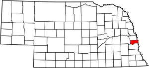 |
| Saunders County | 155 | Wahoo | 1856 | Formed from Douglas and Lancaster Counties | Alvin Saunders, a governor of the Nebraska Territory | 6 | 20,929 | 754 sq mi (1,953 km2) | 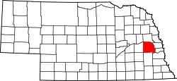 |
| Scotts Bluff County | 157 | Gering | 1888 | Formed from Cheyenne County | Named for a towering bluff located in the Scotts Bluff National Monument; the bluffs themselves are named for Hiram Scott, a fur trapper who is alleged to have crawled 75 miles with a broken leg before collapsing and dying at the foot of the formation | 21 | 36,848 | 739 sq mi (1,914 km2) | 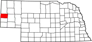 |
| Seward County | 159 | Seward | 1855 | Formed from Cass and Pierce Counties | William Henry Seward, the United States Secretary of State during the 1860s | 16 | 17,089 | 575 sq mi (1,489 km2) | 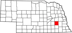 |
| Sheridan County | 161 | Rushville | 1885 | Formed from Sioux County | Philip Henry Sheridan, a general in the American Civil War | 61 | 5,251 | 2,441 sq mi (6,322 km2) | 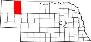 |
| Sherman County | 163 | Loup City | 1871 | Formed from Buffalo County and unorganized territory | William Tecumseh Sherman, the American Civil War general | 56 | 3,106 | 566 sq mi (1,466 km2) | 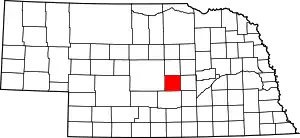 |
| Sioux County | 165 | Harrison | 1877 | Unorganized territory | Sioux Native American tribe | 80 | 1,475 | 1,313 sq mi (3,401 km2) | 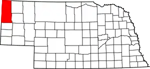 |
| Stanton County | 167 | Stanton | 1855 | Formed from Burt County | Edwin M. Stanton, the United States Secretary of War during most of the American Civil War | 53 | 6,133 | 430 sq mi (1,114 km2) | 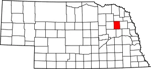 |
| Thayer County | 169 | Hebron | 1871 | Formed from Jefferson County | John Milton Thayer, the seventh governor of Nebraska | 32 | 5,189 | 575 sq mi (1,489 km2) | 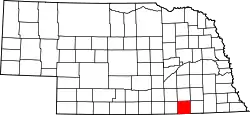 |
| Thomas County | 171 | Thedford | 1887 | Unorganized territory | George Henry Thomas, a general in the American Civil War | 89 | 699 | 713 sq mi (1,847 km2) | 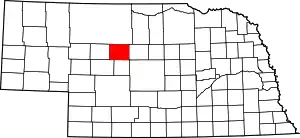 |
| Thurston County | 173 | Pender | 1889 | Formed form Blackbird County and an Omaha Indian reservation | John Mellen Thurston, a U. S. senator from Nebraska | 55 | 6,895 | 394 sq mi (1,020 km2) | 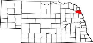 |
| Valley County | 175 | Ord | 1871 | Unorganized territory | Named for the many valleys in the area | 47 | 4,193 | 568 sq mi (1,471 km2) | 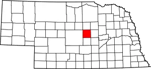 |
| Washington County | 177 | Blair | 1854 | One of nine original counties | George Washington, the first president of the United States | 29 | 20,223 | 390 sq mi (1,010 km2) | 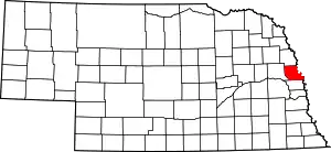 |
| Wayne County | 179 | Wayne | 1867 | Unorganized territory | Anthony Wayne, the American Revolutionary War general nicknamed "Mad Anthony" by his troops | 27 | 9,411 | 444 sq mi (1,150 km2) | 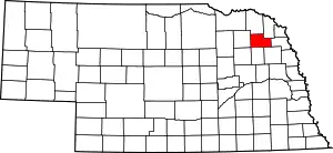 |
| Webster County | 181 | Red Cloud | 1867 | Unorganized territory | Daniel Webster, the statesman and U.S. Senator from Massachusetts | 45 | 3,688 | 575 sq mi (1,489 km2) | 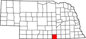 |
| Wheeler County | 183 | Bartlett | 1877 | Unorganized territory | Daniel H. Wheeler, a secretary of the Nebraska State Board of Agriculture | 84 | 759 | 575 sq mi (1,489 km2) | 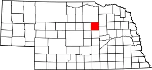 |
| York County | 185 | York | 1855 | Formed from Cass County, Pierce County, and unorganized territory | Named for either York, England, or York County, Pennsylvania | 17 | 13,883 | 576 sq mi (1,492 km2) | 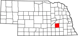 |
Former counties
- Clay (1855-1864) Formed from unorganized territory and dissolved into Gage and Lancaster County.
- Jackson (1855-1856) Formed from unorganized territory and dissolved to Fillmore County and unorganized territory
- Johnson (1855-1856) Formed from unorganized territory and dissolved to unorganized territory
- Blackbird (1855-1888) Formed from Burt County and dissolved to Thurston County
- Loup (1855-1856) Formed from Burt and Un-Organized and then dissolved Madison, Monroe and Platte Counties
- Jones (1856-1866) Formed from unorganized territory and dissolved into Jefferson County.
- Grant, Harrison, Jackson, Lynn, Monroe and Taylor counties listed in 1870 - see map
- West (1860-1862) Formed from unorganized territory and dissolved into Holt County
References
- "EPA County FIPS Code Listing". EPA.gov. Retrieved 2008-05-04.
- National Association of Counties. "NACo County Explorer". Retrieved 2015-10-25.
- The license plate prefix sequence is derived from the number of vehicles registered in each county in 1922.
- Fitzpatrick, Lilian Linder (1925). "Nebraska Place-Names". University of Nebraska Department of English. Retrieved 2010-09-02.

This article is issued from Wikipedia. The text is licensed under Creative Commons - Attribution - Sharealike. Additional terms may apply for the media files.