Crofton, Kentucky
Crofton is a home rule-class city in Christian County, Kentucky, in the United States. The population was 749 at the 2010 census.[3]
Crofton, Kentucky | |
|---|---|
| Motto(s): Small Town... Big Heart | |
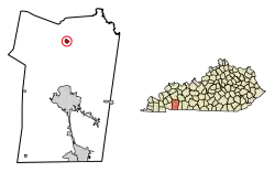 Location of Crofton in Christian County, Kentucky. | |
| Coordinates: 37°2′52″N 87°29′7″W | |
| Country | United States |
| State | Kentucky |
| County | Christian |
| Area | |
| • Total | 0.64 sq mi (1.64 km2) |
| • Land | 0.64 sq mi (1.64 km2) |
| • Water | 0.00 sq mi (0.00 km2) |
| Elevation | 597 ft (182 m) |
| Population (2010) | |
| • Total | 749 |
| • Estimate (2019)[2] | 707 |
| • Density | 1,113.39/sq mi (430.19/km2) |
| Time zone | UTC-6 (Central (CST)) |
| • Summer (DST) | UTC-5 (CDT) |
| ZIP code | 42217 |
| Area code(s) | 270 & 364 |
| FIPS code | 21-18658 |
| GNIS feature ID | 0490363 |
| Website | www |
Crofton is part of the Clarksville, TN–KY Metropolitan Statistical Area.
History
Crofton had its start when the railroad was extended to that point.[4] Incorporated in 1873, the city is named for pioneer James Croft, the original owner of the town site.[5]
Geography
Crofton is located in northern Christian County at 37°2′52″N 87°29′7″W (37.047752, -87.485260).[6] U.S. Route 41 passes through the center of town as Madisonville Street, and the I-169 passes east of Crofton, with access from Exit 23. Hopkinsville, the Christian County seat, is 13 miles (21 km) to the south, and Madisonville is 22 miles (35 km) to the north.
According to the United States Census Bureau, Crofton has a total area of 0.6 square miles (1.6 km2), all land.[3]
Demographics
| Historical population | |||
|---|---|---|---|
| Census | Pop. | %± | |
| 1880 | 136 | — | |
| 1890 | 428 | 214.7% | |
| 1900 | 278 | −35.0% | |
| 1910 | 402 | 44.6% | |
| 1920 | 527 | 31.1% | |
| 1930 | 461 | −12.5% | |
| 1940 | 688 | 49.2% | |
| 1950 | 500 | −27.3% | |
| 1960 | 892 | 78.4% | |
| 1970 | 631 | −29.3% | |
| 1980 | 823 | 30.4% | |
| 1990 | 699 | −15.1% | |
| 2000 | 838 | 19.9% | |
| 2010 | 749 | −10.6% | |
| 2019 (est.) | 707 | [2] | −5.6% |
| U.S. Decennial Census[7] | |||
As of the census[8] of 2000, there were 838 people, 353 households, and 234 families residing in the city. The population density was 1,318.6 people per square mile (505.6/km2). There were 380 housing units at an average density of 598.0 per square mile (229.2/km2). The racial makeup of the city was 85.44% White, 12.65% African American, 0.12% Native American or Alaska Native, and 1.79% from two or more races. Hispanics or Latinos of any race were 0.24% of the population.
There were 353 households, out of which 30.9% had children under the age of 18 living with them, 44.2% were married couples living together, 17.0% had a female householder with no husband present, and 33.7% were non-families. 31.2% of all households were made up of individuals, and 14.7% had someone living alone who was 65 years of age or older. The average household size was 2.37 and the average family size was 2.96.
The age distribution was 25.5% under the age of 18, 7.0% from 18 to 24, 29.5% from 25 to 44, 21.0% from 45 to 64, and 16.9% who were 65 years of age or older. The median age was 37 years. For every 100 females, there were 76.1 males. For every 100 females age 18 and over, there were 77.3 males.
The median income for a household in the city was $25,625, and the median income for a family was $28,542. Males had a median income of $31,442 versus $17,109 for females. The per capita income for the city was $14,021. About 26.0% of families and 25.6% of the population were below the poverty line, including 33.1% of those under age 18 and 29.5% of those age 65 or over.
References
- "2019 U.S. Gazetteer Files". United States Census Bureau. Retrieved July 24, 2020.
- "Population and Housing Unit Estimates". United States Census Bureau. May 24, 2020. Retrieved May 27, 2020.
- "Geographic Identifiers: 2010 Demographic Profile Data (G001): Crofton city, Kentucky". U.S. Census Bureau, American Factfinder. Archived from the original on February 12, 2020. Retrieved August 11, 2014.
- "Our Oldest Town". Kentucky New Era. June 6, 1974. p. 4. Retrieved 18 October 2015.
- "Dictionary of Places: Crofton". Encyclopedia of Kentucky. New York, New York: Somerset Publishers. 1987. ISBN 0-403-09981-1.
- "US Gazetteer files: 2010, 2000, and 1990". United States Census Bureau. 2011-02-12. Retrieved 2011-04-23.
- "Census of Population and Housing". Census.gov. Retrieved June 4, 2015.
- "U.S. Census website". United States Census Bureau. Retrieved 2008-01-31.
External links
Municipalities and communities of Christian County, Kentucky, United States | ||
|---|---|---|
| Cities | 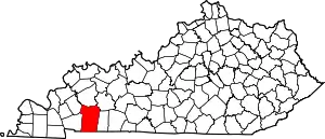 Location of Christian County, Kentucky | |
| CDPs | ||
| Unincorporated communities | ||
| Footnotes | ‡This populated place also has portions in an adjacent county or counties | |
| ||
| Authority control |
|---|