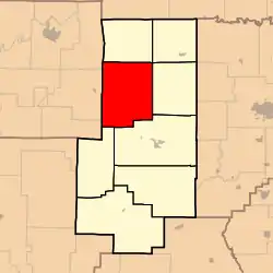
Crooked Creek Township, Bollinger County, Missouri
Crooked Creek Township is one of eight townships in Bollinger County, Missouri, USA. As of the 2000 U.S. Census, its population was 1,182. As of the 2010 U.S. Census, the population had increased to 1,234. Crooked Creek Township covers an area of 84.74 square miles (219.5 km2).
Crooked Creek Township | |
|---|---|
 | |
| Coordinates: 37°25′10″N 090°03′36″W | |
| Country | United States |
| State | Missouri |
| County | Bollinger |
| Area | |
| • Total | 84.74 sq mi (219.49 km2) |
| • Land | 84.67 sq mi (219.29 km2) |
| • Water | 0.07 sq mi (0.19 km2) 0.09% |
| Elevation | 794 ft (242 m) |
| Population (2010) | |
| • Total | 1,234 |
| • Density | 14.56/sq mi (23.43/km2) |
| FIPS code | 29-17380[2] |
| GNIS feature ID | 0766321 |
Crooked Creek Township was established in 1872, and named after a creek of the same name noted for its irregular course.[3]
Demographics
As of the 2010 U.S. Census, there were 1,234 people living in the township. The population density was 14.56 people per square mile (23.43/km2). There were 631 housing units in the township. The racial makeup of the township was 97.49% White, 0.24% Black or African American, 1.70% Native American, 0.08% Asian, and 0.49% from two or more races. Approximately 0.49% of the population were Hispanic or Latino of any race.
Geography
Incorporated Areas
The township contains no incorporated settlements.
Unincorporated Areas
The township contains the unincorporated areas and historical communities of Bessville, Grisham, Lodge, Shrum, and Tallent.
Cemeteries
The township contains the following nine cemeteries: Berry, Dalton, Hawn, Lincoln, McMahan, Moores, Old Concord, Slinkard, and Wallis.
Streams
The streams of Alex Branch, Big Blue Branch, Denton Creek, Hawn Creek, Henson Branch, Huffmans Creek, Indian Creek, Punch Creek, Reagan Branch, Shrum Branch, Stones Branch, Summers Creek, Turkey Creek and Turkey Creek flow through Crooked Creek Township.
Landmarks
- Amidon Memorial Conservation Area
- Hawn Access
Administrative Districts
School Districts
- Meadow Heights R-II School District
- Woodland R-IV School District
Political Districts
- Missouri's 8th Congressional District
- State House District 145
- State Senate District 27
References
- "US Board on Geographic Names". United States Geological Survey. 2007-10-25. Retrieved 2008-01-31.
- "U.S. Census website". United States Census Bureau. Retrieved 2008-01-31.
- "Bollinger County Place Names, 1928-1945 (archived)". The State Historical Society of Missouri. Archived from the original on 24 June 2016. Retrieved 2 September 2016.CS1 maint: bot: original URL status unknown (link)
External links
Municipalities and communities of Bollinger County, Missouri, United States | ||
|---|---|---|
| City | 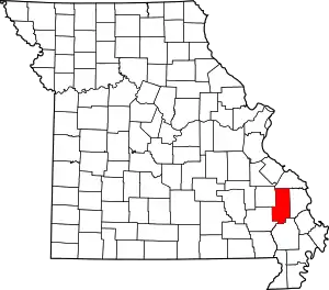 Map of Missouri highlighting Bollinger County | |
| Villages | ||
| Townships | ||
| Unincorporated communities | ||
| Abandoned villages | ||
| ||