Culrain railway station
Culrain railway station serves the village of Culrain on the Kyle of Sutherland in the Highland council area of Scotland. It is located on the Far North Line. It is 61 miles 0 chains (98.2 km) from Inverness, and has a single platform which is long enough for a five-coach train. The railway line through Culrain is single track, with the nearest passing loop to the north being at Lairg and to the south at Ardgay.[3]
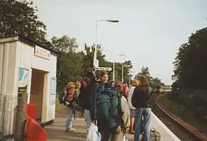 Culrain station with students who stayed at Carbisdale Castle waiting for the train in 1996 | |
| Location | Culrain, Highland Scotland |
| Coordinates | 57.9196°N 4.4045°W |
| Grid reference | NH576947 |
| Managed by | Abellio ScotRail |
| Platforms | 1 |
| Other information | |
| Station code | CUA |
| History | |
| Original company | Sutherland Railway |
| Pre-grouping | Highland Railway |
| Post-grouping | LMSR |
| Key dates | |
| 1871[2] | Opened |
| Passengers | |
| 2015/16 | |
| 2016/17 | |
| 2017/18 | |
| 2018/19 | |
| 2019/20 | |
| Notes | |
Passenger statistics from the Office of Rail and Road | |
The station is close to Carbisdale Castle, which operated from 1945 to 2011 as a youth hostel owned by the Scottish Youth Hostels Association. The hostel has been closed since 2011 as a result of structural damage. Following its sale to a consortium in 2016,[4] planning permission was granted in 2017/2018 to turn the castle back into a private residence but now with swimming pool.[5]
Services
Timetable changes in December 2008 increased the number of trains through Culrain. On Mondays to Saturdays, there are four trains a day southbound to Inverness and northbound to Wick. On Sundays, there is one train in each direction.
In December 2013 it became a request stop.[6]
| Preceding station | Following station | |||
|---|---|---|---|---|
| Ardgay | Abellio ScotRail Far North Line |
Invershin | ||
| Historical railways | ||||
| Bonar Bridge Line and Station open |
Highland Railway Sutherland Railway |
Invershin Line and Station open | ||
References
Notes
- Brailsford 2017, Gaelic/English Station Index.
- Butt 1995, p. 74.
- Brailsford 2017, map 20D.
- "Buyer found for Carbisdale Castle". BBC News. 23 September 2016. Retrieved 7 February 2020.
- Butlin, Heather. "Planning permission". www.highland.gov.uk. Retrieved 7 February 2020.
- "Expanded train services from December 2013". Archived from the original on 29 October 2013. Retrieved 27 October 2013.
Sources
- Brailsford, Martyn, ed. (December 2017) [1987]. Railway Track Diagrams 1: Scotland & Isle of Man (6th ed.). Frome: Trackmaps. ISBN 978-0-9549866-9-8.
- Butt, R. V. J. (1995). The Directory of Railway Stations: details every public and private passenger station, halt, platform and stopping place, past and present (1st ed.). Sparkford: Patrick Stephens Ltd. ISBN 978-1-85260-508-7. OCLC 60251199.
- Jowett, Alan (March 1989). Jowett's Railway Atlas of Great Britain and Ireland: From Pre-Grouping to the Present Day (1st ed.). Sparkford: Patrick Stephens Ltd. ISBN 978-1-85260-086-0. OCLC 22311137.