Curran, Michigan
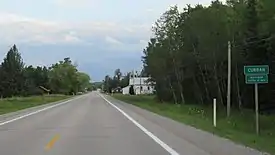
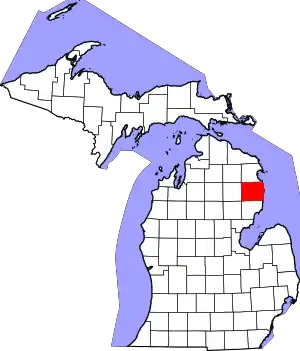
Curran (/kʌrˈræn/ KURR-ran) is an unincorporated community in Alcona County in the U.S. state of Michigan.[1] The community is located within Mitchell Township. As an unincorporated community, Curran has no legally defined boundaries or population statistics of its own but does have its own post office with the 48728 ZIP Code.[2]
Curran, Michigan | |
|---|---|
 | |
| Motto(s): "Black Bear Capital of Michigan" | |
 Curran Location within the state of Michigan  Curran Location within the United States | |
| Coordinates: 44°42′53″N 83°48′28″W | |
| Country | United States |
| State | Michigan |
| County | Alcona |
| Township | Mitchell |
| Settled | 1875 |
| Elevation | 922 ft (281 m) |
| Time zone | UTC-5 (Eastern (EST)) |
| • Summer (DST) | UTC-4 (EDT) |
| ZIP code(s) | 48728 |
| Area code(s) | 989 |
| GNIS feature ID | 1619642[1] |

Geography
Curran is centered along the concurrency of M-65 and M-72, which is referred to locally as North Curran Road. The community is in Northern Michigan within Mitchell Township in western Alcona County about 45 miles (72 km) northwest of the city of Oscoda.[3] The community sits at an elevation of 922 feet (281 m) above sea level.[1]
Little Wolf Creek and Yoder Creek run through the center of the community.[4][5] Curran is also surrounded by the Huron National Forest.
Curran is served by Fairview Area School District, which is mostly to the west in Oscoda County. The eastern portion of the community may be served by Alcona Community Schools.[6]
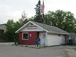
Curran uses its own post office with the 48728 ZIP Code, which covers most of the sparsely-populated areas of western Alcona County. It serves most of Mitchell Township, as well as small portions of Alcona Township, Caledonia Township, and Millen Township to the east. The Curran post office also serves small portions of Comins Township and Clinton Township to the west in Oscoda County, as well as a very small portion of Ossineke Township to the north in Alpena County.[2][7]
Other nearby communities include Fairview and Mio to the west, Comins to the northwest, and Barton City and Hubbard Lake to the east.[8]
History
Curran was first settled by Phillip Curran, who built a lumber camp in the area in 1875. More settlers arrived around 1886. In 1890, the Loud & Sons Lumber Company, managed by George Loud, built a narrow-gauge railway through the area. Curran maintained his logging business until all of the white pines were depleted by the 1920s. By then, the community had grown to a population of around 150.[9]
The community received its first post office on April 28, 1890 with Edward Cunning as the first postmaster. In the same year, it was discontinued on September 30 but quickly reestablished on October 10 with John Fullerton assuming postmaster duties.[9][10] Mitchell Township, where Curran is located, was also formally organized in 1890. The township hall is located within Curran at 6849 West Tower Road.[11] The current post office building is located at 2071 North Curran Road.[12]
The Curran Cemetery, formerly known as the Fullerton Family Cemetery, is a township-owned cemetery established in 1905. It is located just southeast of the community center along Small Road at 44°42′16″N 83°47′07″W.[13][14]
Curran is unofficially referred to as the "Black Bear Capital of Michigan" due to the abundance of American black bears in the area, and the title is also extended to Mitchell Township as a whole.[9][11] The title is also used by the unincorporated community of Strongs in Chippewa Township in the state's Upper Peninsula.[15] Curran hosts the annual Black Bear Festival every September.[16] The event was founded in 2005 and features a car show, craft show, music, and vendors. The 2020 Black Bear Festival was cancelled due to the ongoing COVID-19 pandemic in Michigan.[17]
References
- U.S. Geological Survey Geographic Names Information System: Curran, Michigan
- UnitedStatesZipCodes.org (2020). "ZIP Code 48728: Curran". Retrieved December 7, 2020.
- Michigan Economic Development Corporation (2020). "Oscoda Area Convention and Vistors Bureau". Retrieved December 8, 2020.
- U.S. Geological Survey Geographic Names Information System: Little Wolf Creek
- U.S. Geological Survey Geographic Names Information System: Yoder Creek
- Michigan Geographic Framework (15 November 2013). "Alcona County School Districts" (PDF). Retrieved December 8, 2020.
- Google (December 7, 2020). "48728 ZIP Code map" (Map). Google Maps. Google. Retrieved December 7, 2020.
- Google (December 3, 2020). "Curran, Michigan" (Map). Google Maps. Google. Retrieved December 3, 2020.
- Robinson, John (6 April 2020). "Michigan Shadow Town: Curran, in Alcona County". Retrieved December 8, 2020.
- Romig, Walter (1986) [1973]. Michigan Place Names. Detroit, Michigan: Wayne State University Press. ISBN 0-8143-1838-X.
- Mitchell Township, MI (2019). "Welcome to Mitchell Township". Retrieved December 8, 2020.
- U.S. Geological Survey Geographic Names Information System: Curran Post Office
- U.S. Geological Survey Geographic Names Information System: Curran Cemetery
- Find a Grave (2020). "Curran Cemetery". Retrieved December 6, 2020.
- "Talk with the Doc: Upper Peninsula fun facts for 2020". The Mining Journal. Booth Newspapers. 7 July 2020. Retrieved December 7, 2020.
- Alcona County Quilt Trail Project (June 2015). "Alcona County Quilt Trail" (PDF). Retrieved December 3, 2020.
- Curran Black Bear Festival, Inc. (2020). "Curran Black Bear Festival". Retrieved December 6, 2020.
