Cyclone Ernie
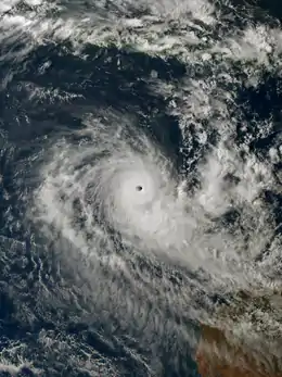
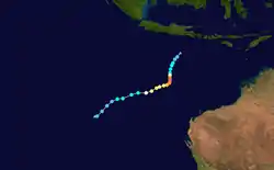
Severe Tropical Cyclone Ernie was one of the quickest strengthening tropical cyclones on record. Ernie was the first Category 5 severe tropical cyclone in the Australian region since Cyclone Marcia in 2015, and also the strongest tropical cyclone in the Australian region since Cyclone Ita in 2014.[1][2][3] Ernie developed from a tropical low into a cyclone south of Indonesia in the northeast Indian Ocean on 6 April 2017, and proceeded to intensify extremely rapidly to a Category 5 severe tropical cyclone.[1] A few days later, on 10 April, the system was downgraded below cyclone intensity following a period of rapid weakening (though not nearly as rapid as its intensification), located southwest of its original position. Ernie had no known impacts on any land areas.[1]
| Category 5 severe tropical cyclone (Aus scale) | |
|---|---|
| Category 5 tropical cyclone (SSHWS) | |
 Ernie rapidly intensifying to the northwest of Western Australia on 7 April | |
| Formed | 5 April 2017 |
| Dissipated | 14 April 2017 |
| (Post-tropical after 10 April) | |
| Highest winds | 10-minute sustained: 220 km/h (140 mph) 1-minute sustained: 260 km/h (160 mph) Gusts: 315 km/h (195 mph) |
| Lowest pressure | 924 hPa (mbar); 27.29 inHg |
| Fatalities | None |
| Damage | None |
| Areas affected | None |
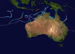
| Part of the 2016–17 Australian region cyclone season | |
Meteorological history

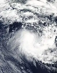
On 5 April 2017, the Australian Bureau of Meteorology began monitoring a developing tropical low located in the northeast Indian Ocean, approximately 710 km (440 mi) east of Christmas Island.[1] The system had been tracking in a generally westwards direction during the previous few days as a weak area of low pressure, but had not been significant enough to warrant the issuance of tropical cyclone warnings.[2] The tropical low tracked south-westwards throughout the day of 5 April, before adopting a course to the south-southwest during the night.[1] On the morning of 6 April, sustained gale-force winds developed on the western side of the system.[1][4] Despite the existence of these cyclone-strength winds,[5][6] the Bureau of Meteorology still classified the storm as a tropical low because they did not extend more than halfway around the system.[7]
The storm continued its trend of steady intensification, and was upgraded to a Category 1 cyclone on the Australian tropical cyclone intensity scale by 12:00 UTC on 6 April.[1] The storm was assigned the name Ernie – the seventh tropical cyclone and sixth named storm of the 2016-17 Australian region cyclone season.[8] This intensification to Category 1 status marked the beginning of a period of explosive intensification lasting about 24–30 hours, which concluded with Ernie being upgraded to a Category 5 severe tropical cyclone at about 12:00 UTC on 7 April.[1] Upon strengthening to Category 5 intensity, the cyclone had 10-minute sustained winds of 205 km/h (125 mph), gusting to 285 km/h (180 mph).[9] Aided by favourable environmental conditions, including sea surface temperatures of 29-30 °C (84-86 °F), the cyclone maintained its Category 5 intensity for more than 12 hours, while still tracking to the south-southwest.[1][9] Ernie continued to intensify gradually during this time, peaking with 10-minute sustained winds of 220 km/h (140 mph), gusts to 315 km/h (195 mph), and a central pressure of 922 hPa (27.23 inHg).[1] Its maximum one-minute sustained wind speed of 260 km/h (160 mph) at this time made the storm the equivalent of a lower-end Category 5 major hurricane on the Saffir–Simpson Hurricane Wind Scale (SSHWS).[2][3]

Soon afterwards, the system turned to the west-southwest and encountered an unfavorable environment of increased wind shear, dryer air, and cooler sea surface temperatures,[1][4] which caused Ernie to weaken. The storm was downgraded to Category 3 status by 12:00 UTC on 8 April, about one day after it reached Category 5 intensity.[1] Ernie's decline in strength was paused, though, when the system began to re-intensify a few hours later, on the morning of 9 April, local time. The renewed period of strengthening proved short-lived and meager, however, as Ernie began weakening again on the afternoon of the same day, before it could reattain Category 4 status.[1] The cyclone was downgraded below severe tropical cyclone status to Category 2 intensity by 12:00 UTC on 9 April, and then further to Category 1 intensity by 00:00 UTC on the following day.[1] Ernie weakened below tropical cyclone intensity by 06:00 UTC on 10 April, ending its short but significant 90-hour existence as a cyclone.[1] Gales persisted in the southern quadrants of the system for a number of hours despite its declassification, due to the steep pressure gradient caused by a high pressure ridge to the south.[1] Ex-Tropical Cyclone Ernie continued to track to the west-southwest, and later in a more southerly direction, until the remnants of the system dissipated four days later.
Rapid intensification
Severe Tropical Cyclone Ernie was a particularly noteworthy cyclone due to its extremely rapid rate of intensification. On the morning of 6 April, when gale-force winds were present on the western side of the developing tropical low, the storm was predicted to remain relatively weak, and reach only a marginal Category 2 intensity by the early hours of 8 April local time.[4][10] After that time, it was forecast to weaken gradually while tracking to the west-southwest. As time progressed, the system attained Category 2 intensity while located 720 km (445 mi) southeast of Christmas Island, and Ernie's maximum predicted strength was raised to Category 3.[4]
Soon, in defiance of even this raised intensity forecast, environmental conditions became near perfect for Ernie to intensify extremely rapidly, and to a high degree. The storm intensified to a Category 4 severe tropical cyclone by 06:00 UTC on 7 April, then reached Category 5 status at about 12:00 UTC.[1][4] From this point on, the cyclone continued to strengthen further, however at a much less frenetic pace.[1][9] Overall, Severe Tropical Cyclone Ernie intensified from a tropical low to a Category 5 severe tropical cyclone in just 24–30 hours. The Bureau of Meteorology labelled this period of explosive intensification as ‘extraordinary’ in the cyclone's severe weather report.[1]
Impacts
Throughout its existence, Ernie tracked generally southwards as it intensified, and then generally to the west-southwest as it weakened.[1] This track led the system to be located a considerable distance away from all land areas, including well to the northwest of Western Australia, well to the east of Christmas Island and the Cocos (Keeling) Islands, and well to the south of Indonesia.[1] Consequently, Ernie did not cause any known impacts on land in terms of property damage, heavy rain or strong winds and was not retired from the list of names used by the BOM.[1]
See also
- Cyclone Gillian – intensified rapidly from Category 3 to Category 5 on the Australian scale in 24 hours in March 2014, in a similar area to Ernie
- Cyclone Gwenda – intensified explosively northwest of Australia in April 1999, with a 10-minute sustained wind increase of 150 km/h (90 mph) and pressure decrease of 90 hPa (mbar; 2.66 inHg) in 30 hours
- Cyclone Hellen – intensified explosively in the Mozambique Channel in March 2014 at a rate Metéo-France referred to as 'astounding'[11]
- Cyclone Ita – intensified explosively while approaching the Far North Queensland coast from Papua New Guinea in 2014
- Hurricane Patricia – the second strongest tropical cyclone worldwide with a pressure of 872 hPa (mbar; 25.75 inHg), intensified explosively in the eastern Pacific Ocean from a tropical storm to a Category 5 major hurricane on the Saffir–Simpson scale in 24 hours during October 2015
- Hurricane Wilma – the strongest Atlantic hurricane on record, intensified explosively in the Caribbean Sea from a Category 1 hurricane to a Category 5 major hurricane on the Saffir–Simpson scale in 24 hours during October 2005
References
- "Tropical Cyclone Ernie Impacts". www.bom.gov.au. Retrieved 6 May 2017.
- "Cyclone Ernie Best Track Data".
- "Saffir-Simpson Hurricane Wind Scale". www.nhc.noaa.gov. Retrieved 6 May 2017.
- "WA Tropical Cyclone Season 2016/2017 - Weatherzone Forums". forum.weatherzone.com.au. Archived from the original on 16 March 2018. Retrieved 6 May 2017.
- "Marine Weather Definitions". www.bom.gov.au. Retrieved 6 May 2017.
- Meteorology, corporateName=Bureau of. "Tropical Cyclones". www.bom.gov.au. Retrieved 6 May 2017.
- Meteorology, corporateName=Bureau of. "Tropical Cyclones". www.bom.gov.au. Retrieved 6 May 2017.
- "Tropical Cyclone 22U Impacts". www.bom.gov.au. Retrieved 6 May 2017.
- "Tropical Cyclone "Ernie" rapidly intensifies off Western Australia". The Watchers - Daily news service | Watchers.NEWS. Retrieved 6 May 2017.
- "Weather News - Cyclone Ernie to dodge Australia". www.weatherzone.com.au. Retrieved 6 May 2017.
- "WebCite query result". www.webcitation.org. Archived from the original on 30 March 2014. Retrieved 7 May 2017.CS1 maint: bot: original URL status unknown (link)
