Daigo, Ibaraki
Daigo (大子町, Daigo-machi) is a town located in Ibaraki Prefecture, Japan. As of 1 July 2020, the town had an estimated population of 15,771 in 6431 households and a population density of 48.4 inhabitants per square kilometre (125/sq mi). The percentage of the population aged over 65 was 46.6%.[1] The total area of the town is 325.76 square kilometres (125.78 sq mi).
Daigo
大子町 | |
|---|---|
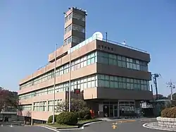 Daigo town office | |
 Flag  Seal | |
 Location of Daigo in Ibaraki Prefecture | |
 Daigo | |
| Coordinates: 36°46′5.2″N 140°21′18.8″E | |
| Country | Japan |
| Region | Kantō |
| Prefecture | Ibaraki |
| District | Kuji |
| Area | |
| • Total | 325.76 km2 (125.78 sq mi) |
| Population (September 2020) | |
| • Total | 15,725 |
| • Density | 48/km2 (130/sq mi) |
| Time zone | UTC+9 (Japan Standard Time) |
| - Tree | Fagus crenata |
| - Flower | Tea |
| - Bird | Aix galericulata |
| Phone number | 0295-72-1111 |
| Address | 866 Daigo, Daigo-machi, Kuji-gun, Ibaraki-ken 319-3526 |
| Website | Official website |
Geography
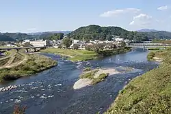
Located in northwestern Ibaraki Prefecture along the upper reaches of the Kuji River, Daigo is bordered to the north by Fukushima Prefecture and to the west by Tochigi Prefecture.
Surrounding municipalities
Ibaraki Prefecture
Fukushima Prefecture
Tochigi Prefecture
- Ōtawara
- Nakagawa
Climate
Although the altitude is relatively low at 120 meters, Daigo is very chilly in the morning and evening in winter because it is located in a basin. The average minimum temperature of minus 5.5 ℃ in January is almost the same as Morioka, Iwate, much further north, and Daigo is known for having some of the coldest winters in the Kantō region. However, during the daytime, the temperature rises to nearly 10 °C due to solar radiation. In addition, summers often record hot days.
| Climate data for Daigo(1981 - 2010) | |||||||||||||
|---|---|---|---|---|---|---|---|---|---|---|---|---|---|
| Month | Jan | Feb | Mar | Apr | May | Jun | Jul | Aug | Sep | Oct | Nov | Dec | Year |
| Record high °C (°F) | 17.9 (64.2) |
22.5 (72.5) |
26.0 (78.8) |
31.5 (88.7) |
33.5 (92.3) |
36.5 (97.7) |
38.3 (100.9) |
39.0 (102.2) |
37.3 (99.1) |
31.7 (89.1) |
24.3 (75.7) |
24.1 (75.4) |
39.0 (102.2) |
| Average high °C (°F) | 8.1 (46.6) |
8.8 (47.8) |
12.2 (54.0) |
18.3 (64.9) |
22.8 (73.0) |
25.5 (77.9) |
29.2 (84.6) |
30.9 (87.6) |
26.5 (79.7) |
20.9 (69.6) |
15.4 (59.7) |
10.6 (51.1) |
19.1 (66.4) |
| Daily mean °C (°F) | 0.4 (32.7) |
1.4 (34.5) |
4.9 (40.8) |
10.8 (51.4) |
15.7 (60.3) |
19.6 (67.3) |
23.4 (74.1) |
24.7 (76.5) |
20.7 (69.3) |
14.3 (57.7) |
7.9 (46.2) |
2.6 (36.7) |
12.2 (54.0) |
| Average low °C (°F) | −5.5 (22.1) |
−4.7 (23.5) |
−1.4 (29.5) |
3.9 (39.0) |
9.8 (49.6) |
15.1 (59.2) |
19.4 (66.9) |
20.6 (69.1) |
16.5 (61.7) |
9.4 (48.9) |
2.4 (36.3) |
−3.1 (26.4) |
6.9 (44.4) |
| Record low °C (°F) | −15.6 (3.9) |
−14.0 (6.8) |
−11.0 (12.2) |
−6.0 (21.2) |
−0.6 (30.9) |
5.9 (42.6) |
10.3 (50.5) |
11.3 (52.3) |
4.6 (40.3) |
−1.7 (28.9) |
−6.2 (20.8) |
−10.8 (12.6) |
−15.6 (3.9) |
| Average precipitation mm (inches) | 36.6 (1.44) |
45.0 (1.77) |
96.4 (3.80) |
112.7 (4.44) |
135.1 (5.32) |
151.5 (5.96) |
194.7 (7.67) |
205.6 (8.09) |
201.4 (7.93) |
139.2 (5.48) |
75.4 (2.97) |
38.0 (1.50) |
1,435.1 (56.50) |
| Average precipitation days (≥ 1.0 mm) | 4.8 | 5.4 | 9.9 | 10.9 | 12.2 | 13.5 | 14.7 | 11.1 | 12.6 | 10.8 | 7.1 | 4.0 | 117 |
| Mean monthly sunshine hours | 173.0 | 168.6 | 172.2 | 169.7 | 154.6 | 115.4 | 118.7 | 137.2 | 112.1 | 127.9 | 142.7 | 166.6 | 1,755.6 |
| Source 1: Japan Meteorological Agency | |||||||||||||
| Source 2: 観測史上1位~10位の値 | |||||||||||||
Demographics
Per Japanese census data,[2] the population of Daigo has decreased drastically and is now less than half of what it was 60 years ago.
| Year | Pop. | ±% |
|---|---|---|
| 1950 | 44,784 | — |
| 1960 | 40,178 | −10.3% |
| 1970 | 32,953 | −18.0% |
| 1980 | 29,524 | −10.4% |
| 1990 | 27,067 | −8.3% |
| 2000 | 23,892 | −11.7% |
| 2010 | 20,041 | −16.1% |
History
Daigo village was created with the establishment of the modern municipalities system on April 1, 1889. It was elevated to town status on July 20, 1891. On March 31, 1955, the villages of Yorigami, Fukuroda, Miyagawa, Kurosawa, Namase, Kamiogawa, Shimoogawa and Murotono merged with Daigo.
Government
Daigo has a mayor-council form of government with a directly elected mayor and a unicameral town council of 13 members. Daigo, together with neighboring Hitachiōta, contributes two members to the Ibaraki Prefectural Assembly. In terms of national politics, the town is part of Ibaraki 5th district of the lower house of the Diet of Japan.
Economy
Daigo is noted for many onsen (hot springs) located in Daigo, which provide sees revenue and for food processing.
Education
Daigo has six public elementary schools and four public middle schools operated by the city government, and one public high school operated by the Ibaraki Prefectural Board of Education. There is also one private high school. The prefecture also operates one special education school for the handicapped.
Transportation
Highway
Local attractions
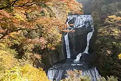
- Fukuroda Falls – one of Japan's Top 100 Waterfalls
- Daigo onsen
- Fukuroda onsen
Noted people
- Yasunori Kikuchi, professional baseball player
- Yasumitsu Toyoda, professional baseball player
References
- "Ibaraki prefectural official statistics" (in Japanese). Japan.
- Daigo population statistics
External links
![]() Media related to Daigo, Ibaraki at Wikimedia Commons
Media related to Daigo, Ibaraki at Wikimedia Commons
- Official Website (in Japanese)
| Core city | ||
|---|---|---|
| Special city | ||
| Cities | ||
| Districts | ||
| Authority control |
|---|