Moriya, Ibaraki
Moriya (守谷市, Moriya-shi) is a city located in Ibaraki Prefecture, Japan. As of 1 October 2020, the city had an estimated population of 68,777 in 28,103 households and a population density of 1926 persons per km². The percentage of the population aged over 65 was 23.1%.[1] The total area of the city is 35.71 square kilometres (13.79 sq mi).
Moriya
守谷市 | |
|---|---|
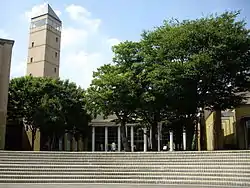 Moriya city hall | |
 Flag  Seal | |
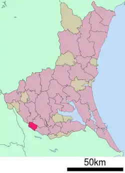 Location of Moriya in Ibaraki Prefecture | |
 Moriya | |
| Coordinates: 35°57′5.1″N 139°58′31.5″E | |
| Country | Japan |
| Region | Kantō |
| Prefecture | Ibaraki |
| Area | |
| • Total | 35.71 km2 (13.79 sq mi) |
| Population (October 2020) | |
| • Total | 68,777 |
| • Density | 1,900/km2 (5,000/sq mi) |
| Time zone | UTC+9 (Japan Standard Time) |
| - Tree | Pine |
| - Flower | Lilium auratum |
| - Bird | Chinese bamboo partridge |
| Phone number | 0297-45-1111 |
| Address | Okashiwa 950-1, Moriya-shi, Ibaraki-ken 302-0116 |
| Website | Official website |
Geography
Moriya is located in southwestern Ibaraki Prefecture, bordering on Chiba Prefecture to the southwest. The city is surrounded by three rivers, the Kinugawa, Kokaigawa and the Tone River, one of the longest rivers in Japan. In terms of area, it is the smallest city in Ibaraki Prefecture. It is located approximately 35 kilometers from central Tokyo.
Climate
Moriya has a Humid continental climate (Köppen Cfa) characterized by warm summers and cool winters with light snowfall. The average annual temperature in Moriya is 14.4 °C. The average annual rainfall is 1325 mm with September as the wettest month. The temperatures are highest on average in August, at around 26.3 °C, and lowest in January, at around 3.5 °C.[2]
Demographics
Per Japanese census data,[3] the population of Moriya has expanded rapidly since the 1970s
| Year | Pop. | ±% |
|---|---|---|
| 1920 | 38,559 | — |
| 1930 | 37,829 | −1.9% |
| 1940 | 37,718 | −0.3% |
| 1950 | 12,160 | −67.8% |
| 1960 | 11,449 | −5.8% |
| 1970 | 12,300 | +7.4% |
| 1980 | 17,585 | +43.0% |
| 1990 | 35,427 | +101.5% |
| 2000 | 50,362 | +42.2% |
| 2010 | 62,434 | +24.0% |
History
Moriya developed in the Kamakura period as a castle town ruled by the Sōma clan, who ruled northern Shimōsa Province. During the Edo period Tokugawa shogunate, much of the area was ruled as part of Sakura Domain, followed by Sekiyado Domain. The town of Moriya was established within Kitasōma District on April 1, 1889 with the creation of the modern municipalities system. It was elevated to city status February 2, 2002.
Government
Moriya has a mayor-council form of government with a directly elected mayor and a unicameral city council of 20 members. Moriya contributes one member to the Ibaraki Prefectural Assembly. In terms of national politics, the city is part of Ibaraki 3rd district of the lower house of the Diet of Japan.
Economy
Moriya was an agricultural area until the late 1970s, when the development of new towns and industrial parks made it a commuter town and suburb of greater Tokyo.
Education
Moriya has nine public elementary schools and four public middle schools operated by the city government, and one public high school operated by the Ibaraki Prefectural Board of Education. There are also one private elementary school and three private high schools.
Transportation
Highway
.png.webp) Jōban Expressway – Moriya Service Area, Yawara Interchange
Jōban Expressway – Moriya Service Area, Yawara Interchange National Route 294
Sister city relations
 - Greeley, Colorado, USA, sister city since August 1993 [4]
 - Mainburg, Germany, friendship city since September 1990 [5]
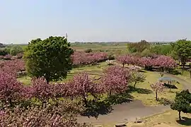
Local attractions
- site of Moriya Castle
Notable people from Moriya
- Masakatsu Sawa, professional football player
- Takuya Terada, actor, singer, model
References
- "Ibaraki prefectural official statistics" (in Japanese). Japan.
- Moriya climate data
- Moriya population statistics
- "Moriya, Japan Student Exchange Program". Cultural Affairs Division, City of Greeley. Retrieved 13 December 2015.
- "Partnerstadt Moriya (Japan)". Leben in Mainburg (in German). Stadt Mainburg im Hopfenlan. 2015. Retrieved 13 December 2015.
External links
| Wikimedia Commons has media related to Moriya, Ibaraki. |
- Official Website (in Japanese)
| Core city | ||
|---|---|---|
| Special city | ||
| Cities | ||
| Districts | ||
| Authority control |
|---|