Dalbeattie
Dalbeattie (/dælˈbiːti/, Scots: Dawbeattie,[2] Scottish Gaelic: Dail Bheithe meaning 'haugh of the birch' or Dail bhàite 'drowned (i.e. liable to flood) haugh') is a town in the historical county of Kirkcudbrightshire in Dumfries and Galloway, Scotland. Dalbeattie is in a wooded valley on the Urr Water 4 miles (6 km) east of Castle Douglas and 12 miles (19 km) south west of Dumfries. The town is famed for its granite industry and for being the home town of William McMaster Murdoch, the First Officer of the RMS Titanic.
Dalbeattie
| |
|---|---|
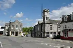 Dalbeattie Town Hall | |
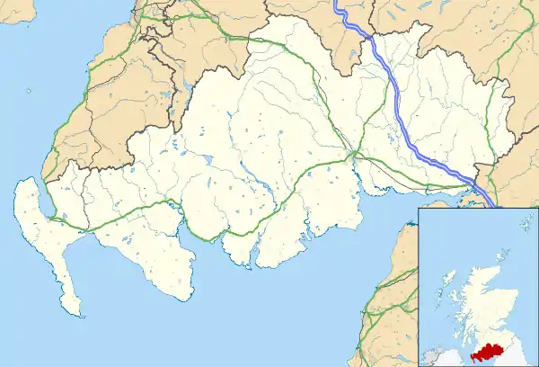 Dalbeattie Location within Dumfries and Galloway | |
| Population | 4,200 (mid-2016 est.)[1] |
| OS grid reference | NX832613 |
| Council area | |
| Lieutenancy area | |
| Country | Scotland |
| Sovereign state | United Kingdom |
| Post town | DALBEATTIE |
| Postcode district | DG5 |
| Dialling code | 01556 |
| Police | Scotland |
| Fire | Scottish |
| Ambulance | Scottish |
| UK Parliament | |
| Scottish Parliament | |
Etymology
Dalbeattie is a Gaelic name, recorded in 1469 as Dalbaty.[3] The first element of the name is Gaelic dail 'water-meadow, haugh'. There are two possible interpretations for the second element. The most common is Gaelic beithich, genitive singular of beitheach 'abounding in or relating to birch trees', derived from beith 'birch'.[3][4][5] Dalbeattie would thus mean 'haugh of the birch'. The second interpretation takes -beattie to be bhàite (from bàite) 'drowned', meaning 'liable to flooding'.[3] W. J. Watson offers this derivation for Dalbate in Middleby.[6]
Dalbeattie is popularly interpreted as 'birch valley' or 'birch vale', which is adopted in the names of local businesses such as Birch Valley Dental Clinic[7] and Birchvale Theatre.[8] The interpretation of the first element as 'vale' or 'valley' may be due to confusion with the word dale. The association with 'valley' goes back to at least 1955, when the Third Statistical Account records that the 'accepted derivation' is Celtic, meaning 'the valley of the birches'.[9]:325
History
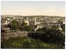
There are indications from Court Records that a settlement existed on the site as early as 1658 and it is further mentioned in 1747. There is also evidence from Presbytery Records which indicate there was a School Master in Dalbeattie in 1751.
The formal beginnings of Dalbeattie originate in 1781 when George Maxwell of Munches and Alexander Copeland of Kingsgrange (or Colliston) decided to encourage the development of the town by feuing their property. The Maxwells owned the land on the north side of the burn and the Copelands owned the land on the south side. Every feu consisted of a piece of land, fronting a street, large enough to build a house and grow vegetables and keep chickens and pigs. Each feu also had the right to cut turves (peat) from Aucheninnes Moss. This was important as fuel was scarce in Galloway, coal was expensive and there were very few trees. The feu duties brought in an income for the landowners and gave security for the tenants.
The building of the bridge over the River Urr at Craignair in 1797 and the rapid expansion of the granite industry in Dalbeattie attracted more people to settle in the town. By 1810 work in the quarries was plentiful, and over the next 30 years a lot of tradespeople settled and founded businesses in Dalbeattie. However, the expanded population brought other problems, high incidents of sickness, including cholera and typhoid, and law-and-order issues.
The town today has a greatly reduced industry, and most residents commute to the nearby town of Dumfries for employment. The town is frequented by tourists as its position is well situated for access to the Solway coast.
Governance
The town is under the management of Dumfries and Galloway council and is located in the Abbey ward. The town is in the Westminster constituency of Dumfries and Galloway and currently represent by Alister Jack. In the Scottish Parliament the town is within the Galloway and Upper Nithsdale constituency and the South of Scotland region and was represented by Alex Fergusson.
Geography
Dalbeattie is situated in the Urr valley of which most of the east side is covered by forest. The River Urr flows from the north southwards to the Solway Firth and passes by the west side of the town. The town has an abundance of distinctive grey granite.
Economy
Granite Quarrying
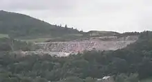
Formerly granite quarrying was an important part of the Dalbeattie economy. The most prominent of which is the characteristic Craignair quarry which is clearly visible to the west of the town. Dalbeattie Granite works was established in 1820 and was situated in Craignair Street, following a direct route from Craignair quarry. The industry died down locally around 1883 due to cheaper imports from Denmark.
Many of the workers emigrated to other parts of the world in order to find work, a number emigrated to the United States to work at a sister quarry in Westerly, Rhode Island. Granite exported from Dalbeattie went into the Mersey Docks in Liverpool, the Thames Embankment in London, various British lighthouses, even as far as the lighthouse at the southern tip of Ceylon (Sri Lanka).[10] Its most famous use was probably the Eddystone Lighthouse in southern England.
Dalbeattie is credited with developing the technique of polishing granite stone to form a shiny surface. This technique was exported throughout the world by the skilled workers of Dalbeattie as they travelled.
Modern Day
The town has a sawmill which employs many local people, and a souvenir factory.
Most of the residents commute to nearby Dumfries for employment.
Landmarks
- The war memorial in Colliston Park was unveiled on September 1921, attended by Mr William Duncan.[11] It commemorates those that died in World War I and, with additions, those that died in World War II.[11] The memorial is a simplified version of the Mercat Cross in Edinburgh made of Dalbeattie granite, topped with the lion rampant of Galloway by Pilkington Jackson.[12]:211[13] The designers were W S Macgeorge and E.A. Hornel.[11]
- The fountain on the junction of Mill Street and High Street was built in 1887 by D.H. & J. Newall to celebrate the Golden Jubilee of Queen Victoria.[12]:212
- The single arch Buittle Bridge, or Craignair Bridge, that crosses the Urr Water is a Category A Listed building. It was completed in 1797 and replaced an earlier 2-arch bridge upstream which was destroyed by flooding shortly after it was built. The bridge is notable for having an unusually wide span for a single arch construction.[14]
Transport
The town is accessible by roads from Dumfries, Castle Douglas, and is on the Solway coastal road. A regular bus service based in Dumfries travels through Dalbeattie and Castle Douglas to the west of the region and back. The town also acts as a minor hub for bus routes across the Solway coast. The town previously had access to the rail network; however, this was removed in the 1960s as it was deemed unprofitable.
Museums and Galleries
Dalbeattie has a museum[15] devoted to the history of the town and surrounding area. There is also a small art gallery, the Nail Factory[16] which hosts temporary exhibitions, usually of work by local artists.
Notable people
- Bishop Andrew Carruthers, (1770-1852) was a priest and horticulturist and builder of St Peter's Church. On 29 June 2014 it celebrated its 200th anniversary.
- Murray Grierson is a retired rally driver who won the Scottish Rally Championship in 1987 using an Opel Kadett 400 and again in 1993 using a MG Metro 6R4. He also won numerous British National Championship rallies, finishing runner-up in the Championship in 1988 in an Opel Kadett 400 and again in 1997 and 1998, when he used a Subaru Impreza 555. Latterly, he was often seen on rounds of the World Rally Championship doing gravel notes for Colin McRae and Alister McRae.
- Alister Jack (born 7 July 1963) is a Scottish politician serving as Secretary of State for Scotland since 2019. Raised in Dalbeattie and Kippford.
- John Keats and his friend Charles Armitage Brown stayed at an inn here on their walking tour of Scotland in 1818.[17]
- John Maxwell (1905-1962) artist born in the town and later travelled around Europe, he exhibited at the Royal Scottish Academy in 1935.
- Jimmy McKinnell was a professional footballer who played for Dumfries club Queen of the South F.C. and Blackburn Rovers
- William McMaster Murdoch was born and raised in Dalbeattie and is by far the town's most famous resident. He served as First Officer of the RMS Titanic and died when the ship sank on its maiden voyage in 1912. A memorial to Murdoch was placed in the town hall. A charitable prize in his name was established in 1997 after a donation by film director James Cameron. Residents of the town had complained about Cameron's depiction of Murdoch in the 1997 film Titanic.
- Ian Simpson a retired motorcycle racer who won the 1994 British Superbike Championship as well as 3 Isle of Man TT and 5 North West 200 races.
- Jim Steel had a successful career as a footballer playing in England's lower divisions with Oldham Athletic, Wigan Athletic, Wrexham A.F.C., Port Vale and Tranmere Rovers.[18]
- Archbishop John Menzies Strain (1770-1852) in the town for twenty-three years before becoming the first Archbishop of St. Andrews and Edinburgh in 1878.
- Andrew Swann (1878- unknown) professional footballer
- Fr George Thompson (1928-2016) parish priest, 1993-2005 of St Peter's, teacher and former MP for Galloway.
References
- "Mid-2016 Population Estimates for Settlements and Localities in Scotland". National Records of Scotland. 12 March 2018. Retrieved 30 December 2020.
- Andy Eagle (27 February 2003). "The Online Scots Dictionary". Scots-online.org. Retrieved 19 September 2013.
- Grant, Alison (2010). Macleod, Iseabail (ed.). The Pocket Guide to Scottish Place-Names. Glasgow: Richard Drew Ltd. p. 39. ISBN 978-1-899471-00-3. OCLC 759569647.
- Mills, A. D. (2011). A Dictionary of British Place Names. Oxford: Oxford University Press. p. 145.
- "Dalbeattie". www.ainmean-aite.scot. Archived from the original on 27 July 2019. Retrieved 16 August 2020.
- Watson, W. J. (1926). The Celtic Place-Names of Scotland. Edinburgh and London. p. 180. Archived from the original on 21 August 2014.
- "Birchvalley Dental Clinic". birch-valley.co.uk. Archived from the original on 12 January 2019. Retrieved 16 August 2020.
- "Home". www.birchvaletheatre.co.uk. Archived from the original on 10 November 2018. Retrieved 16 August 2020.
- Halliday, R. M. (1955). "The Quoad Sacra Parish and Burgh of Dalbeattie". In Laird, John; Ramsay, D. G.; Arnott, M. C. (eds.). The Third Statistical Account of Scotland: The Stewartry of Kirkcudbright and The County of Wigtown. Glasgow: Collins (published 1965). pp. 324–338.
- Francis Groome, ed. (1885). Ordnance Gazetteer of Scotland: A Survey of Scottish Topography, Statistical, Biographical and Historical. Grange Publishing.
- "Dalbeattie". Imperial War Museums. Archived from the original on 16 August 2020. Retrieved 16 August 2020.
- Gifford, John (2002) [1996]. Dumfries and Galloway. Pevsner Architectural Guides: The Buildings of Scotland. New Haven and London: Yale University Press. ISBN 9780300096712.
- "Inventory: Acc.7445: Papers of the late Charles D'Orville Pilkington Jackson Esq, ARSA, FRBS, FRSA" (PDF). National Library of Scotland Leabharlann Nàiseanta na h-Alba. Archived (PDF) from the original on 16 August 2020. Retrieved 16 August 2020.
- "BUITTLE BRIDGE, DALBEATTIE (ALSO KNOWN AS CRAIGNAIR BRIDGE) (LB3364)". portal.historicenvironment.scot. Archived from the original on 2 February 2017. Retrieved 16 August 2020.
- "Dalbeattie Museum - Dalbeattie Museum". www.dalbeattiemuseum.co.uk.
- "The Nail Factory - Gallery and Art Space".
- Walker, Carol Kyros (1992). Walking North With Keats. New Haven and London: Yale University. pp. 236–237. ISBN 0-300-04824-6.
- "Jim Steel full career profile". Qosfc.com. 19 December 2010. Retrieved 19 September 2013.
| Wikimedia Commons has media related to Dalbeattie. |