Dale Hodges Park
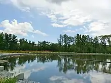
Dale Hodges Park is a 40.4686 hectares (100.000 acres) natural environment urban park in northwest Calgary, Alberta—an expansion of Bowmont Park—that features a massive public art installation combining aesthetics with functionality where stormwater from eight northwest upstream residential communities flows slowly through "water structures and landforms" inspired by "natural river morphology as well as hydrologic and sedimentation processes"[2] that serve as filters. The park, which is connected to the regional pathway, has a boardwalk, cycling and walking trails, the Nautilus Pond, a polishing marsh, a wet meadow, man-made streams, vantage points of the Bow River, and wildlife habitat.[1][3][4]
| Dale Hodges Park | |
|---|---|
 | |
| Type | Urban park |
| Location | 2123 52nd Street N.W. between 40th Avenue N.W. and the Bow River[1]Bowness and Montgomery, Calgary West of Market Mall |
| Nearest city | Calgary, Alberta |
| Coordinates | 51°05′27″N 114°10′40″W [Notes 1] |
| Area | 40.4686 hectares (100.000 acres) |
| Operated by | City of Calgary |
The $26.8 million project to "restore native riparian habitats" of the contaminated Klippert gravel pit, then known as the East Bowmont Natural Environment Park (NEP), began in 2010.[2] It was completed in the fall of 2018 and officially opened to the public on June 26, 2019, following a ceremony in which Mayor Naheed Nenshi dedicated the park to Dale Hodges, in recognition of his many contributions to Calgary as the longest service member of council. Alderman Hodges was active for 30 years—from 1983 to 2013—"protecting and creating Calgary's green spaces".[3]
Features
A City of Calgary press release described the Park as a "one-of-a-kind", "beautiful stormwater treatment facility" that filters and treats stormwater through a combination of natural and man-made processes.[3] One of the main focuses of the project was to improve the underground storm drain system of stormwater collected from eight northwest communities, including Silver Springs and Varsity.[2] Before the creation of Dale Hodges Park, stormwaters from these communities, representing nearly 1,800 hectares (4,400 acres), ran through underground storm drains in the gravel pit, directly into the Bow River.[5] According to a June 26, 2019 City of Calgary press release, Dale Hodges Park "is one of a kind in North America in the way that it is designed to handle and filter the stormwater...The park’s proximity to the river presented a rare and unique opportunity to protect the Bow River ...as it is estimated that the annual sediment loads to the Bow River from this area will be reduced by 50%."[6]
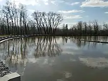
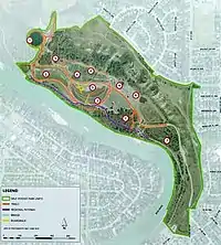
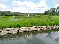
The design includes a Nautilus Pond, a polishing marsh, a wet meadow, a stream, outfall, a dry stream, riparian areas, and a lookout mound.[7][8] The polishing marshes, wet meadow, and a surface stream carry the stormwater from the Nautilus Pond to the polishing marshes. The stream also collects the wet meadow stormwater and "conveys it to the outfall".[8] The lookout knoll is encircled by the marsh with sedge and willows growing nearby.[8] Residential snow and rain runoff travels through pipes then resurfaces in Nautilus Pond which is located at the west of the Park. Large sediment particles are removed in the pond draining system which "swirls the water before dropping it down a halo drain".[5]
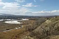
The water moves slowly through meandering man-made side streams in the polishing marsh area where wetland plants remove finer particles.[8] The water flows through "cells" in the park "stopping at various river banks" that "polish" the water before it enters the Bow River.[5] The design for the "sculpted polishing marshes and wet meadows" was a collaboration by O2 Planning + Design, Source 2 Source Inc., and Sans façon for Watershed+.[2] According to the February 2014 East Bowmont NEP Design Development Plan, the collaborators drew their inspiration from the "unique riparian phenomenon" known as anabranches, or "meander[ing] scrolls,[9]:99 which are sections of streams that divert from and then rejoin the main channel of a watercourse.[9]:99 Thousands of trees, bushes and native plants were planted and seeded as part of the restoration process using phytoremediation to treat the contaminated soil from the gravel pit.[9]:5 [Notes 2]
According to O2 Planning + Design, the "final outflow stream discharges to an important trout habitat area, designed to serve as refuge during river flood conditions".[2]
Collaborators
"The design vision for East Bowmont NEP celebrates the valued ecosystems of the Bow River Valley. Drawing inspiration from meander scrolls, a unique riparian phenomenon that leaves a physical record of a river’s changing path over time, the concept plan uses fluvial landforms as a basis for the design approach to the park....An anabranch or meander scroll is a section of a river or stream that diverts from the main channel or stem of the watercourse and rejoins the main stem downstream. Local anabranches can be the result of small islands in the watercourse. In larger anabranches, the flow can diverge for a distance of several kilometres before rejoining the main channel."
— AECOM Canada, Watershed+, O2. "East Bowmont Natural Environment Park Design Development Plan". 2014:99
The transformation of the site, which incorporated "water engineering, public art,[7] landscape architecture and ecological design", was the result of a collaboration between O2 Planning + Design, Source 2 Source Inc., Sans façon for Watershed+[Notes 3][10][11][12] and AECOM.[4][2] Wilco Southwest undertook the construction.[4] The City of Calgary departments involved in the project include Calgary Parks, Water Resources and Public art teams City of Calgary Arts and Culture.[4]
According to a February 27, 2013 article in Canadian Art, the City of Calgary's Department of Utilities and Environmental Protection (UEP) created its own public art program as a result of the City's establishment in 2004 of the City of Calgary’s Public Art Program. In [Notes 4]
Dale Hodges Park is part of a larger series of initiatives undertaken by the City of Calgary for flood mitigation strategies.[2]
Wildlife corridor
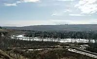
Dale Hodges Park provides habitat for wildlife and is part of Bowmont Park's wildlife corridor connecting Nose Hill Park to the east, Edworthy Park and Shouldice Park downstream from Bowmont Park, and Bowness Park and Baker Parks upstream.[13]:7
History
Bowmont Park was expanded with the addition of the land at the east end of the park, formerly used as a gravel-mining pit, which the City of Calgary had acquired in 2010,[14] to "restore the area’s ecological integrity while improving the underground storm drain system."[5] The Klippert gravel pit, a former gravel-mining pit was run by Klippert Concrete for sixty years.[5] The area was temporarily named the East Bowmont Natural Environment Park (NEP). The City hired AECOM to undertake a scoping study, which was completed in 2010.[15]
One of the first projects in the transformation of the area from gravel pit to a restored natural area, was creation of two "new wet ponds". The wet ponds, which were both educational and functional, serve to "protect the Bow River by incorporating green stormwater treatment", according to Chris Manderson, natural area management lead with the City of Calgary parks department.[16]
By April 2014 Calgary's Recreations department said that the East Bowmont Natural Environment Park (NEP) would become a natural environment park and would "incorporate stormwater treatment for a large northwest Calgary drainage catchment."[7] The NEP was designated as a "high priority as a stormwater quality retrofit project."[7]
In November 2015, the City of Calgary began the actual physical work of developing the Natural Environment Park. The project incorporates "green stormwater treatment as a functional element of the park" with "stormwater wetlands" that provide wildlife habitat".[17]
On April 25, 2017, Calgary's City Council officially renamed East Bowmont Natural Environment Park (NEP) Dale Hodges Park,[9] in recognition of the many contributions to the city made by Alderman Dale Hodges, who had served Calgary from 1983 to 2013, making him Calgary’s longest-serving member of council.[18][19][20][21]
The $2,006,000 project was completed in the fall of 2018,[7] and was officially opened by the Mayor of Calgary on June 26, 2019 at the dedication of the park to Dale Hodges.
Dale Hodges
Dale Hodges served as Calgary City Council Ward 1 Alderman for thirty years—from 1983 until his retirement in 2013.[20][19] In April 2017 the city council surprised Hodges with the news that they had unanimously agreed to rename East Bowmont Park as Dale Hodges Park.[21] Hodges worked extensively to protect and create parks including Nose Hill Park, Baker Park, and Dale Hodges Park. He also worked towards the establishment of the Enmax Legacy Parks Program which provides ongoing funds to maintain the parks.[21]
Notes
- The Google Maps coordinates are for the Nautilus Pond.
- In their 2012 and 2014 reports, O2 Planning + Design Inc said that phytoremediation would be used to treat the contaminated soil from the gravel pit.
- Sans Façon is a collaborative partnership that began in Glasgow c. 2001 between the English artist Tristan Surtees and French architect Charles Blanc. Since 2007, Surtees and Blanc developed and led Watershed+, which is a public art program operating out of the City of Calgary's Department of Utilities and Environmental Protection (UEP) since 2007. Watershed+ adds "creative practice" to water management in Calgary, connecting Calgarians emotionally to the Bow River watershed. In 2016, Sans Façon also worked on Seattle's Combined Sewer Overflow (CSO) project. According to a November 1, 2014 article in Avenue Calgary, Surtees and Blanc, who were included in Calgary's Top 40 under 40, had created Watershed+ in 2009 as a proposal for UEP's Public Art funding. By 2014, Watershed+ had over 20 projects.
- According to a February 27, 2013 article in Canadian Art the City of Calgary’s Public Art Program devotes 1 per cent "of all project costs for municipal capital projects over one million dollars" to public art. By 2013, the "Glasgow-based collective" Sans façon had two commissions with UEP.
External links
- Dale Hodges Park. City of Calgary. June 10, 2019. Retrieved July 16, 2019.
References
- Parks (August 17, 2017). "Dale Hodges Park". Retrieved June 27, 2019.
- "Dale Hodges Park". O2 Planning + Design. nd. Retrieved March 23, 2019.
- "From gravel pit to green space: Dale Hodges Park opens to the public". The City of Calgary. June 27, 2019. Retrieved June 27, 2019.
- "Bowmont Park opens". Sans façon. June 27, 2019. Retrieved June 27, 2019.
- Mutter, Chelsey (June 26, 2019). "Dale Hodges Park is open for Calgary to enjoy". LiveWire Calgary. Retrieved June 27, 2019.
- "Former gravel pit reopens as brand new public park". Daily Hive Calgary. June 27, 2019. Retrieved June 27, 2019.
- "East Bowmont Park Improvement Project". Calgary Recreation. Public Art. April 14, 2014. Retrieved March 24, 2019.
- "Bowmont stormwater quality concept" (PDF), Calgary Parks, 2014, retrieved March 24, 2019
- AECOM Canada, Watershed+, O2 (February 2014). East Bowmont Natural Environment Park Design Development Plan (PDF) (Report). p. 149. Retrieved March 23, 2019.CS1 maint: uses authors parameter (link) The engineering firm AECOM Canada, a local subsidiary of Los Angeles-based AECOM, a multinational, was formerly Tecsult.
- Callahan, Anna (March 1, 2015). "Sans Façon – Tristan Surtees and Charles Blanc – Selected as Planning Artists for Seattle's CSO System". 4Culture. Retrieved June 27, 2019.
- Mellema, Tatiana (February 27, 2013). "Calgary's Watershed+ Revamps Public Art Expectations". Canadian Art. Retrieved June 27, 2019.
- "Charles Blanc and Tristan Surtees". Avenue Calgary. November 1, 2014. Retrieved June 27, 2019.
- Bowmont Park Management Plan (PDF), November 4, 2016, retrieved March 24, 2019
- "Dale Hodges Park opens at former northwest Calgary gravel pit". CBC News. June 26, 2019. Retrieved June 27, 2019.
- "Stormwater Quality Retrofits East Bowmont Scoping Study", City of Calgary, Calgary, 2010
- "Bowmont Park, Northern Bank of the Bow River". Swerve. October 16, 2013. Retrieved May 10, 2017.
- O2 Planning + Design, Inc. (nd), East-Bowmont-park-project, archived from the original on April 7, 2017, retrieved May 10, 2017
- Brandt, Colin (May 9, 2017). "Dale Hodges honoured with naming of Northwest park". Parkdale Community Association. Retrieved March 23, 2019.
- unknown. "The Council Roll of Calgary". Archived from the original on 2013-02-15. Retrieved 2013-01-07.
- Tamara Gignac (2013). "Update: Veteran alderman Dale Hodges to retire, plans to travel". Calgary Herald. Retrieved May 2, 2017.
- Annalise Klingbeil (April 25, 2017). "Calgary council renames northwest park to honour longest-serving councillor". Calgary Herald. Retrieved May 2, 2017.
| Wikimedia Commons has media related to Dale Hodges Park. |
| Landmarks | |
|---|---|
| Attractions | |
| Venues | |
| Parks | |
| Malls | |
| Recreation | |
| |