Dallol (volcano)
Dallol is a cinder cone volcano in the Danakil Depression, northeast of the Erta Ale Range in Ethiopia. It was formed by the intrusion of basaltic magma into Miocene salt deposits and subsequent hydrothermal activity.[1] Phreatic eruptions took place here in 1926, forming Dallol Volcano; numerous other eruption craters dot the salt flats nearby. These craters are the lowest known subaerial volcanic vents in the world, at 45 m (150 ft) or more below sea level. In October 2004 the shallow magma chamber beneath Dallol deflated and fed a magma intrusion southwards beneath the rift.[2] The most recent signs of activity occurred in January 2011 in what may have been a degassing event from deep below the surface.[3]
| Dallol | |
|---|---|
 | |
| Highest point | |
| Elevation | −48 m (−157 ft) |
| Coordinates | 14°14′30″N 40°18′00″E |
| Geography | |
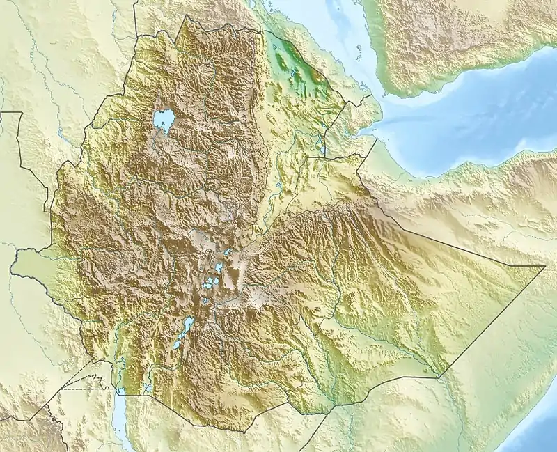 Dallol Location within Ethiopia | |
| Location | Ethiopia |
| Parent range | Danakil Depression |
| Geology | |
| Mountain type | Explosion craters |
| Last eruption | 2011 |
The discovery of the volcano by the first European settlers certainly dates from the first colonization and expeditions in the region, in the 17th or 18th century. But the hostility of the depression, the unbearable heat which reigns there, and the dangers of the site (acid basins, toxic fumes...), did not favour the exploration of the zones close to the crater. On the contrary, the Erta Ale was much more accessible, especially because the part of the rift where it is located (called the Erta Ale Range), is significantly higher. The last eruption of this phreato-magmatic volcano dates back to 1926.[4]
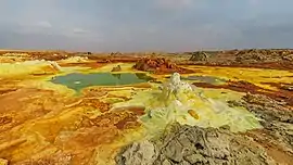
The Dallol area lies up to 120 metres (390 ft) below sea level, and has been repeatedly flooded in the past when waters from the Red Sea have flowed into the depression. The last separation from the Red Sea was about 30,000 years ago. Dallol mountain has an area of about 3 by 1.5 km (1.9 by 0.9 mi), and rises about 60 m (196.9 ft) above the surrounding salt plains. A circular depression near the centre is probably a collapsed crater. The southwestern slopes have water eroded salt canyons, pillars, and blocks. There are numerous saline springs and fields of small fumaroles.[5]
Numerous hot springs discharge brine and acidic liquid here.[6] Small, widespread, temporary geysers produce cones of salt. The Dallol deposits include significant bodies of potash found directly at the surface.[7] The yellow, ochre and brown colourings are the result of the presence of iron and other impurities. Older, inactive springs tend to be dark brown because of oxidation processes.[5]
The term Dallol was coined by the Afar people and means dissolution or disintegration, describing a landscape of green acid ponds (pH-values less than 1) and iron oxide, sulfur and salt desert plains. The area resembles the hot springs areas of Yellowstone Park.
Gallery
 The Danakil desert seen from Dallol
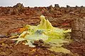 Salt and sulfur formations at Dallol
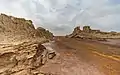 Salt canyons
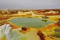 Sulfur ponds
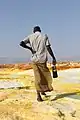 Guide walking on Dallol
See also
- List of volcanoes in Ethiopia
- Dallol – a ghost town in the Dallol crater. It had the record high average temperature for an inhabited location on Earth.
References
- "Dallol salt springs and geysers". Wondermondo. 2011-06-07.
- Nobile, A; Pagli, C; Keir, D; Wright, TJ; Ayele, A; Ruch, J; Acocella, A (October 2012). "Dike-fault interaction during the 2004 Dallol intrusion at the northern edge of the Erta Ale Ridge (Afar, Ethiopia)" (PDF). Geophysical Research Letters. 39 (19): n/a. doi:10.1029/2012GL053152. hdl:2158/1110072.
- "Global Volcanism Program | Dallol". volcano.si.edu.
- Detay, Michel (2011). "Le Dallol revisité : entre explosion phréatomagmatique, rifting intra-continental, manifestations hydrothermales et halocinèse". Lave. 151. doi:10.13140/2.1.2982.4642.
- Roscoe, Richard. "Dallol Volcano". PhotoVolcanica.com. Retrieved 21 December 2020.
- Kotopoulou, Electra; Huertas, Antonio Delgado; García-Ruiz, Juan Manuel; Dominguez-Vera, Jose M.; Lopez-Garcia, Jose Maria; Guerra-Tschuschke, Isabel; Rull, Fernando (2018-12-06). "A poly-extreme hydrothermal system controlled by iron: the case of Dallol at the Afar Triangle". ACS Earth and Space Chemistry. 3 (1): 90–99. doi:10.1021/acsearthspacechem.8b00141. PMC 6380227. PMID 30801049.
- "Dallol in March, 2015". Independent Travellers. independent-travellers.com. Retrieved July 3, 2017.
- "Dallol". Global Volcanism Program. Smithsonian Institution.
- On the Volcanoes of the World episode The Horn of Africa (2008; Science Channel)
External links
| Wikimedia Commons has media related to Dallol. |