Danielsville, Georgia
Danielsville is a city in Madison County, Georgia, United States. The population was 560 at the 2010 census. The city is the county seat of Madison County.[5]
Danielsville, Georgia | |
|---|---|
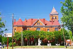 Madison County Courthouse | |
 Location in Madison County and the state of Georgia | |
| Coordinates: 34°7′27″N 83°12′59″W | |
| Country | United States |
| State | Georgia |
| County | Madison |
| Area | |
| • Total | 1.48 sq mi (3.83 km2) |
| • Land | 1.45 sq mi (3.74 km2) |
| • Water | 0.03 sq mi (0.09 km2) |
| Elevation | 728 ft (222 m) |
| Population (2010) | |
| • Total | 560 |
| • Estimate (2019)[2] | 594 |
| • Density | 410.79/sq mi (158.66/km2) |
| Time zone | UTC-5 (Eastern (EST)) |
| • Summer (DST) | UTC-4 (EDT) |
| ZIP code | 30633 |
| Area code(s) | 706 |
| FIPS code | 13-21632[3] |
| GNIS feature ID | 0331511[4] |
History
Danielsville was named for General Allen Daniel (1772-1836),[6] Major-General of the Fourth Division of Georgia Militia 1812-17 and both state senator and representative of Elbert and Madison Counties, and Speaker of the Georgia House of Representatives in 1822. His father was at one time thought to be a Captain Allen Daniel of Virginia, a veteran of the American Revolutionary War, but this has been disproved. In 1812, Danielsville was designated seat of the newly formed Madison County.[7] Danielsville was incorporated as a town in 1817 and as a city in 1908.[8]
Lynching of Lent Shaw
On April 11, 1936, 45-year-old a black man, [called Lint Shaw in newspaper accounts] was arrested by Madison County police in connection with the rape of two white girls. Shaw, who resisted arrest, was shot three times by police before being taken to the county jail in Danielsville. By late evening, word had spread of Shaw's arrest, and a crowd of about 150 white county residents gathered at the jail, demanding Shaw be released to them. The crowd began prying apart the brick wall of the jail when 74-year-old judge Berry Mosely, who had been confined to bed with an illness, arrived and began talking down the crowd. In the meantime, the county sheriff began rounding up deputies, and called in nearby National Guard soldiers. Judge Mosely ordered the sheriff to take Shaw to a hospital, and when the National Guard soldiers arrived, they backed a truck up to the jail and sped away to Athens before the crowd could react. No one was severely injured in the incident, but the damaged jail had to be repaired.[9]
Two weeks later, Shaw was escorted back to Danielsville to face trial. The mob reappeared, and Mosely again ordered Shaw moved away for his safety, this time to Royston. That location was not far enough to protect him from the mob, which followed Shaw to the jail there. In the middle of the night, the mob stormed the jail and lynched Shaw, leaving his hanging body to be found the next day. His death was the 468th lynching in Georgia since 1889.[10]
Geography
Danielsville is located at 34°7′27″N 83°12′59″W (34.124244, -83.216496).[11] The city lies northeast of Athens along U.S. Route 29. Georgia State Route 98 passes through the northeastern part of Danielsville.
According to the United States Census Bureau, the city has a total area of 1.1 square miles (2.8 km2), of which 1.1 square miles (2.8 km2) is land and 0.89% is water.
Demographics
| Historical population | |||
|---|---|---|---|
| Census | Pop. | %± | |
| 1880 | 128 | — | |
| 1890 | 149 | 16.4% | |
| 1900 | 194 | 30.2% | |
| 1910 | 323 | 66.5% | |
| 1920 | 355 | 9.9% | |
| 1930 | 296 | −16.6% | |
| 1940 | 333 | 12.5% | |
| 1950 | 298 | −10.5% | |
| 1960 | 362 | 21.5% | |
| 1970 | 378 | 4.4% | |
| 1980 | 354 | −6.3% | |
| 1990 | 318 | −10.2% | |
| 2000 | 457 | 43.7% | |
| 2010 | 560 | 22.5% | |
| 2019 (est.) | 594 | [2] | 6.1% |
| U.S. Decennial Census[12] | |||
As of the census[3] of 2000, there were 457 people, 193 households, and 119 families residing in the city. The population density was 412.4 people per square mile (159.0/km2). There were 216 housing units at an average density of 194.9 per square mile (75.1/km2). The racial makeup of the city was 95.40% White, 2.19% Black or African American, 0.44% Native American, 1.09% from other races, and 0.88% from two or more races. 3.50% of the population were Hispanic or Latino of any race.
There were 193 households, out of which 29.5% had children under the age of 18 living with them, 49.2% were married couples living together, 9.8% had a female householder with no husband present, and 38.3% were non-families. 34.7% of all households were made up of individuals, and 18.1% had someone living alone who was 65 years of age or older. The average household size was 2.25 and the average family size was 2.92.
In the city, the population was spread out, with 22.8% under the age of 18, 9.6% from 18 to 24, 34.1% from 25 to 44, 18.8% from 45 to 64, and 14.7% who were 65 years of age or older. The median age was 34 years. For every 100 females, there were 92.0 males. For every 100 females age 18 and over, there were 91.8 males.
The median income for a household in the city was $37,639, and the median income for a family was $43,542. Males had a median income of $30,469 versus $22,188 for females. The per capita income for the city was $14,086. About 8.8% of families and 12.4% of the population were below the poverty line, including 13.7% of those under age 18 and 11.8% of those age 65 or over.
Education
Madison County School District
The Madison County School District holds pre-school to grade twelve, and consists of five elementary schools, a middle school, and a high school.[13] The district has 290 full-time teachers and over 4,621 students.[14]
- Colbert Elementary School
- Comer Elementary School
- Danielsville Elementary School
- Hull-Sanford Elementary School
- Ila Elementary School
- Madison County Middle School
- Madison County High School
- Broad River College and Career Academy.
-
Notable people
- Crawford W. Long, the man who first used ether in surgery, was born in Danielsville.
- Jake Westbrook, American Major League baseball player
References
| Wikimedia Commons has media related to Danielsville, Georgia. |
- "2019 U.S. Gazetteer Files". United States Census Bureau. Retrieved July 9, 2020.
- "Population and Housing Unit Estimates". United States Census Bureau. May 24, 2020. Retrieved May 27, 2020.
- "U.S. Census website". United States Census Bureau. Retrieved 2008-01-31.
- "US Board on Geographic Names". United States Geological Survey. 2007-10-25. Retrieved 2008-01-31.
- "Find a County". National Association of Counties. Archived from the original on 2011-05-31. Retrieved 2011-06-07.
- Gannett, Henry (1905). The Origin of Certain Place Names in the United States. Govt. Print. Off. pp. 99.
- Krakow, Kenneth K. (1975). Georgia Place-Names: Their History and Origins (PDF). Macon, GA: Winship Press. p. 58. ISBN 0-915430-00-2.
- Hellmann, Paul T. (May 13, 2013). Historical Gazetteer of the United States. Routledge. p. 227. ISBN 978-1135948597. Retrieved 30 November 2013.
- The Associated Press. "Troops save Negro from Georgia mob", The New York Times. April 12, 1936. Page 1.
- "Races: 468th & 469th; 248th", Time Magazine. May 11, 1936. Retrieved April 12, 2011.
- "US Gazetteer files: 2010, 2000, and 1990". United States Census Bureau. 2011-02-12. Retrieved 2011-04-23.
- "Census of Population and Housing". Census.gov. Retrieved June 4, 2015.
- Georgia Board of Education, Retrieved June 23, 2010.
- School Stats, Retrieved June 23, 2010.
Municipalities and communities of Madison County, Georgia, United States | ||
|---|---|---|
| Cities | 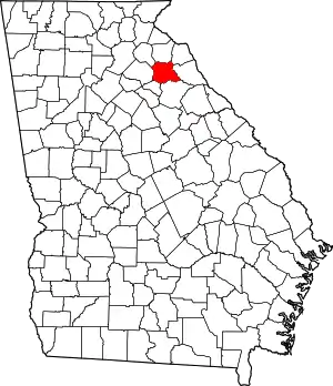 Map of Georgia highlighting Madison County | |
| Unincorporated communities | ||
| Footnotes | ‡This populated place also has portions in an adjacent county or counties | |
| ||