Madison County, Georgia
Madison County is a county located in the northeastern part of the U.S. state of Georgia. As of the 2010 census, the population was 28,120.[1] The county seat is Danielsville.[2] The county was created on December 5, 1811. The county's largest city is Comer with a population of 1,200.
Madison County | |
|---|---|
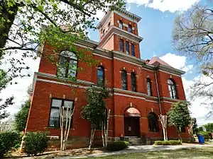 Madison County Courthouse in Danielsville | |
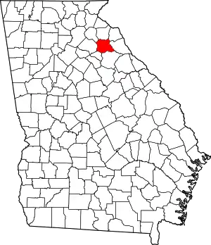 Location within the U.S. state of Georgia | |
 Georgia's location within the U.S. | |
| Coordinates: 34°08′N 83°13′W | |
| Country | |
| State | |
| Founded | December 5, 1811 |
| Named for | James Madison |
| Seat | Danielsville |
| Largest city | Comer |
| Area | |
| • Total | 286 sq mi (740 km2) |
| • Land | 282 sq mi (730 km2) |
| • Water | 3.3 sq mi (9 km2) 1.1% |
| Population | |
| • Estimate (2018) | 29,650 |
| • Density | 100/sq mi (40/km2) |
| Time zone | UTC−5 (Eastern) |
| • Summer (DST) | UTC−4 (EDT) |
| Congressional district | 9th |
| Website | www |
Madison County was included in the Athens-Clarke County, GA Metropolitan Statistical Area, which is included in the Atlanta-Athens-Clarke County-Sandy Springs, GA Combined Statistical Area.
History
Madison County was organized by an act of the General Assembly of Georgia on December 11, 1811. It was named for James Madison,[3] who served as the fourth president of the United States from 1809 to 1817. It was the 38th county formed in Georgia, and began to function as a county in 1812. Madison County was formed from the counties of Clarke, Elbert, Franklin, Jackson, Oglethorpe.[4]
Early agriculture in Madison County was devoted to food crops and livestock (cattle, hogs, and sheep), which were sufficient to feed the population. Just after the Civil War ended, the demand for a cash crop led to major reliance on cotton.[5] The soils of Madison County were heavily damaged by this cotton monoculture. From the 1930s on, agriculture became more diverse. Today, agribusiness dominates the local economy, with poultry production particularly important.
Madison and Oglethorpe counties share Watson Mill Bridge State Park, the site of the longest covered bridge in Georgia. The bridge, which is over 100 years old, spans 229 feet of the South Fork of the Broad River. There are also facilities for camping, hiking trails, picnicking, and fishing in the park.
The Madison County Courthouse, one of the most ornate in Georgia, was built in 1901 for the sum of $18,314. It is listed on the National Register of Historic Places. New Hope Presbyterian Church, established in 1788, is the third oldest church in Georgia.[6]
Lt. Col. Lemuel Penn, a decorated veteran of World War II and a United States Army Reserve officer, was murdered by members of the Ku Klux Klan on July 11, 1964, nine days after passage of the Civil Rights Act, on a Broad River bridge on the Georgia State Route 172 in Madison County.[7][8]
Geography
According to the U.S. Census Bureau, the county has a total area of 286 square miles (740 km2), of which 282 square miles (730 km2) is land and 3.3 square miles (8.5 km2) (1.1%) is water.[9]
The vast majority of Madison County is located in the Broad River sub-basin of the Savannah River basin, with just a very small portion of the county's western edge located in the Upper Oconee River sub-basin of the Altamaha River basin.[10]
Adjacent counties
- Franklin County, Georgia - north
- Hart County, Georgia - northeast
- Elbert County, Georgia - east
- Oglethorpe County, Georgia - south
- Clarke County, Georgia - southwest
- Jackson County, Georgia - west
- Banks County, Georgia - northwest
Demographics
| Historical population | |||
|---|---|---|---|
| Census | Pop. | %± | |
| 1820 | 3,735 | — | |
| 1830 | 4,646 | 24.4% | |
| 1840 | 4,510 | −2.9% | |
| 1850 | 5,703 | 26.5% | |
| 1860 | 5,933 | 4.0% | |
| 1870 | 5,227 | −11.9% | |
| 1880 | 7,977 | 52.6% | |
| 1890 | 11,024 | 38.2% | |
| 1900 | 13,224 | 20.0% | |
| 1910 | 16,851 | 27.4% | |
| 1920 | 18,803 | 11.6% | |
| 1930 | 14,921 | −20.6% | |
| 1940 | 13,431 | −10.0% | |
| 1950 | 12,238 | −8.9% | |
| 1960 | 11,246 | −8.1% | |
| 1970 | 13,517 | 20.2% | |
| 1980 | 17,747 | 31.3% | |
| 1990 | 21,050 | 18.6% | |
| 2000 | 25,730 | 22.2% | |
| 2010 | 28,120 | 9.3% | |
| 2018 (est.) | 29,650 | [11] | 5.4% |
| U.S. Decennial Census[12] 1790-1960[13] 1900-1990[14] 1990-2000[15] 2010-2013[1] | |||
2000 census
As of the census[16] of 2000, there were 25,730 people, 9,800 households, and 7,330 families living in the county. The population density was 91 people per square mile (35/km2). There were 10,520 housing units at an average density of 37 per square mile (14/km2). The racial makeup of the county was 89.01% White, 8.46% Black or African American, 0.19% Native American, 0.28% Asian, 0.03% Pacific Islander, 1.03% from other races, and 0.99% from two or more races. 1.97% of the population were Hispanic or Latino of any race.
There were 9,800 households, out of which 34.60% had children under the age of 18 living with them, 60.60% were married couples living together 10.60% had a female householder with no husband present, and 25.20% were non-families. 21.50% of all households were made up of individuals, and 8.00% had someone living alone who was 65 years of age or older. The average household size was 2.61 and the average family size was 3.04.
In the county, the population was spread out, with 26.30% under the age of 18, 8.20% from 18 to 24, 30.60% from 25 to 44, 23.90% from 45 to 64, and 11.00% who were 65 years of age or older. The median age was 36 years. For every 100 females, there were 96.60 males. For every 100 females age 18 and over, there were 93.70 males.
The median income for a household in the county was $36,347, and the median income for a family was $42,189. Males had a median income of $31,324 versus $22,426 for females. The per capita income for the county was $16,998. About 9.20% of families and 11.60% of the population were below the poverty line, including 14.00% of those under age 18 and 16.50% of those age 65 or over.
2010 census
As of the 2010 United States Census, there were 28,120 people, 10,508 households, and 7,804 families living in the county.[17] The population density was 99.6 inhabitants per square mile (38.5/km2). There were 11,784 housing units at an average density of 41.7 per square mile (16.1/km2).[18] The racial makeup of the county was 87.6% white, 8.4% black or African American, 0.6% Asian, 0.3% American Indian, 1.9% from other races, and 1.2% from two or more races. Those of Hispanic or Latino origin made up 4.1% of the population.[17] In terms of ancestry, 20.7% were American, 9.1% were Irish, 9.1% were English, and 7.2% were German.[19]
Of the 10,508 households, 35.4% had children under the age of 18 living with them, 56.9% were married couples living together, 12.1% had a female householder with no husband present, 25.7% were non-families, and 21.5% of all households were made up of individuals. The average household size was 2.66 and the average family size was 3.07. The median age was 39.4 years.[17]
The median income for a household in the county was $41,343 and the median income for a family was $49,713. Males had a median income of $37,963 versus $28,732 for females. The per capita income for the county was $18,975. About 14.7% of families and 17.8% of the population were below the poverty line, including 22.7% of those under age 18 and 18.4% of those age 65 or over.[20]
Government
The citizens of Madison County are represented by an elected six member board of commissioners. Each commissioner represents one of five districts plus a chairman of the board elected at large for the whole county.
Board of Commissioners
- Chairman – John Scarborough
- District 1 – Lee Allen
- District 2 – Tripp Strickland
- District 3 – Theresa Bettis
- District 4 – John Pethel, Sr.
- District 5 – Derek Doster
| Year | Republican | Democratic | Third parties |
|---|---|---|---|
| 2020 | 75.8% 11,326 | 22.8% 3,411 | 1.4% 200 |
| 2016 | 76.2% 9,201 | 20.1% 2,425 | 3.8% 455 |
| 2012 | 75.8% 8,443 | 22.4% 2,494 | 1.8% 196 |
| 2008 | 72.4% 8,226 | 26.1% 2,965 | 1.5% 174 |
| 2004 | 73.6% 7,254 | 25.6% 2,527 | 0.8% 75 |
| 2000 | 69.2% 5,529 | 28.6% 2,285 | 2.2% 179 |
| 1996 | 53.4% 3,992 | 34.4% 2,571 | 12.2% 913 |
| 1992 | 48.6% 3,351 | 34.7% 2,393 | 16.7% 1149 |
| 1988 | 69.1% 3,724 | 30.4% 1,639 | 0.5% 26 |
| 1984 | 69.0% 3,768 | 31.0% 1,690 | |
| 1980 | 43.1% 2,330 | 55.2% 2,980 | 1.7% 91 |
| 1976 | 24.9% 1,115 | 75.1% 3,367 | |
| 1972 | 82.0% 2,606 | 18.0% 572 | |
| 1968 | 16.0% 600 | 16.6% 622 | 67.4% 2,529 |
| 1964 | 33.7% 1,190 | 66.3% 2,341 | |
| 1960 | 7.8% 205 | 92.2% 2,418 | |
| 1956 | 6.8% 161 | 93.2% 2,222 | |
| 1952 | 10.6% 225 | 89.4% 1,899 | |
| 1948 | 4.3% 62 | 80.6% 1,160 | 15.1% 217 |
| 1944 | 17.6% 265 | 82.2% 1,235 | 0.1% 2 |
| 1940 | 13.6% 185 | 85.4% 1,160 | 1.0% 14 |
| 1936 | 18.7% 393 | 80.9% 1,697 | 0.4% 8 |
| 1932 | 1.8% 38 | 97.9% 2,124 | 0.4% 8 |
| 1928 | 52.7% 527 | 47.4% 474 | |
| 1924 | 17.6% 121 | 73.5% 504 | 8.9% 61 |
| 1920 | 28.9% 281 | 71.2% 693 | |
| 1916 | 12.6% 181 | 86.1% 1,241 | 1.3% 19 |
| 1912 | 20.2% 146 | 78.0% 564 | 1.8% 13 |
Education
Madison County public education is served by the Madison County School District. The Madison County Board of Education oversees and operates the public charter school system in the School District. Madison County Board of Education operates 5 elementary schools, 1 middle school, 1 high school and 1 career academy.
The Madison County Board of Education is overseen by 5 elected board members, from 5 districts in the county. The Board appoints a School Superintendent who works at the pleasure of the Board as a whole.
The district has 290 full-time teachers and over 4,621 students
- District 1 - Robert Hooper (Nov 2007 - Dec 2018)
- District 2 - Angie McGinnis (Jan 2015 - Dec 2018)
- District 3 - Cindy Nash (Jan 2013 - Dec 2020)
- District 4 - Byron Lee (Jan 2017 - Dec 2020)
- District 5 - Brenda Moon (Jan 2017 - Dec 2020)
School Superintendent - Dr. Allen McCannon (since May 2011)
Public Schools
- Colbert Elementary School
- Comer Elementary School
- Danielsville Elementary School
- Hull-Sanford Elementary School
- Ila Elementary School
- Madison County Middle School (MCMS), Home of the Mustangs
- Madison County High School (MCHS), Home of the Red Raiders
- Broad River College and Career Academy
Private schools
- Union Christian Academy (private), Hull
- The Busy Box Pre-School (private), Hull
- The Learning Train Pre-School (private), Colbert
- Building Blocks Pre-School (private), Hull
Communities
Incorporated Cities
Unincorporated Communities
- Paoli
- Bond
- Bluestone
- Jeptha
- Shiloh
- Neese
- Sanford
- Pocataligo
- Harrison
- Fort Lamar
- Diamond Hill
- Blue Stone
Notable people
- Allen Daniel, Jr. - Major General, Speaker of the Georgia House of Representatives, State Senator, namesake of Danielsville
- Josh Fields - Major League baseball player
- Crawford W. Long - the man who first used ether in surgery was born in Danielsville
- Ralph Hudgens - Georgia Insurance and Safety Fire Commissioner
- Jake Westbrook - former Major League baseball player
Historic sites
- Watson Mill Bridge - the longest original-site covered bridge in Georgia
- Birthplace of Crawford W. Long
- Murder site of Lt. Col. Lemuel Penn
- William Bartram Trail
References
- "State & County QuickFacts". United States Census Bureau. Archived from the original on July 4, 2011. Retrieved February 16, 2014.
- "Find a County". National Association of Counties. Retrieved June 7, 2011.
- Gannett, Henry (1905). The Origin of Certain Place Names in the United States. U.S. Government Printing Office. p. 196.
- Berryman, Mary Love (November 29, 2002). "MADISON COUNTY, GEORGIA - 1938". USGenWeb Archives. Retrieved March 21, 2018.
- David D. Long (1921). "Soil Survey of Madison County, Georgia" (PDF). Nrcs.usda.gov. Retrieved July 11, 2018.
- "Ila". Georgia.gov. Retrieved July 11, 2018.
- Alschuler, Albert W. (February 1995). "Racial Quotas and the Jury". Duke Law Journal. Duke University School of Law. 44 (4): 704–743. doi:10.2307/1372922. JSTOR 1372922.
- Thompson, Jim (July 11, 2004). "Highway 172 revisited". Athens Banner-Herald.
- "US Gazetteer files: 2010, 2000, and 1990". United States Census Bureau. February 12, 2011. Retrieved April 23, 2011.
- "Georgia Soil and Water Conservation Commission Interactive Mapping Experience". Georgia Soil and Water Conservation Commission. Retrieved November 18, 2015.
- "Population and Housing Unit Estimates". Retrieved July 31, 2019.
- "U.S. Decennial Census". United States Census Bureau. Retrieved June 24, 2014.
- "Historical Census Browser". University of Virginia Library. Retrieved June 24, 2014.
- "Population of Counties by Decennial Census: 1900 to 1990". United States Census Bureau. Retrieved June 24, 2014.
- "Census 2000 PHC-T-4. Ranking Tables for Counties: 1990 and 2000" (PDF). United States Census Bureau. Retrieved June 24, 2014.
- "U.S. Census website". United States Census Bureau. Retrieved May 14, 2011.
- "DP-1 Profile of General Population and Housing Characteristics: 2010 Demographic Profile Data". United States Census Bureau. Archived from the original on February 13, 2020. Retrieved December 30, 2015.
- "Population, Housing Units, Area, and Density: 2010 - County". United States Census Bureau. Archived from the original on February 13, 2020. Retrieved December 30, 2015.
- "DP02 SELECTED SOCIAL CHARACTERISTICS IN THE UNITED STATES – 2006-2010 American Community Survey 5-Year Estimates". United States Census Bureau. Archived from the original on February 13, 2020. Retrieved December 30, 2015.
- "DP03 SELECTED ECONOMIC CHARACTERISTICS – 2006-2010 American Community Survey 5-Year Estimates". United States Census Bureau. Archived from the original on February 13, 2020. Retrieved December 30, 2015.
- Leip, David. "Dave Leip's Atlas of U.S. Presidential Elections". uselectionatlas.org. Retrieved March 21, 2018.
External links
Places adjacent to Madison County, Georgia | ||||||||||
|---|---|---|---|---|---|---|---|---|---|---|
| ||||||||||
Municipalities and communities of Madison County, Georgia, United States | ||
|---|---|---|
| Cities | Map of Georgia highlighting Madison County | |
| Unincorporated communities | ||
| Footnotes | ‡This populated place also has portions in an adjacent county or counties | |
| ||

| Authority control |
|---|