Darbuk–Shyok–DBO Road
The Darbuk–Shyok–DBO Road (DS-DBO Road/DSDBO Road), also called the Sub-Sector North Road, is a strategic all-weather road in eastern Ladakh in India, close to the Line of Actual Control with China. It connects Ladakh's capital city Leh, via the villages of Darbuk and Shyok at southern Shyok Valley, with the Daulat Beg Oldi (DBO) post near the northern border. The 220-km long section between Shyok and DBO was constructed between 2000 and 2019 by India's Border Roads Organisation (BRO). The Darbuk–Shyok–DBO Road has reduced the travel time between Leh (Capital of the Union territory of Ladakh) to Daulat Beg Oldie (DBO) from 2 days to 6 hours.[1][2][3]
| Darbuk–Shyok–DBO Road | |||
|---|---|---|---|
| Sub-Sector North Road | |||
| Route information | |||
| Maintained by Border Roads Organisation | |||
| Length | 255 km[1] (158 mi) | ||
| Existed | April 2019–present | ||
| Major junctions | |||
| From | Leh | ||
| Darbuk Shyok | |||
| To | Daulat Beg Oldi (DBO) | ||
| Location | |||
| Districts | Leh district (Nubra) | ||
| Highway system | |||
|
| |||
History
The Darbuk–Shyok–DBO Road traverses the historic winter route, also called the Zamistānee route, used by the trading caravans between Leh and Yarkand. Whereas the summer route would cross the Ladakh Range through the difficult Sasser Pass to reach the Shyok River valley, the winter route used to go via the banks of the Shyok River when the water flow would be much reduced and the frozen river surface could be crossed on foot as needed.[4][5]
Proceeding on the right (western) bank of the Shyok River up to Sultan Chhushku, the route crossed the river to the eastern bank, and followed the valley of Murgo nala to reach the village of Murgo. Here, the summer route also joined the winter route having crossed the Shyok River near Saser Brangsa. From here, the joint route followed Burtsa nala and Depsang nala to reach the Depsang Plains and went on to the Karakoram Pass via Daulat Beg Oldi.[lower-alpha 2]
Route
The BRO road begins near the village of Shyok, which is the on the west bank of the Shyok River after its V-shaped bend. Shyok already has roads leading west, to Leh via Darbuk, and south, leading to Pangong Tso. The BRO road crosses the Shyok river to its right bank and rounds the corner, continuing along its right bank due north (on the west side of the river bed).
After passing the historic campsites of Chhumed, Mundro and Mandaltang, it crosses the river near Sultan Chhushku. A 430-metre-long bridge over the full width of the river bed has been constructed and named the 'Colonel Chewang Rinchen Setu'.[lower-alpha 3]
After the Setu, the road goes through the valley of Murgo Nala to reach the village of Murgo, then the valley of Burtsa Nala to reach the camping site of Burtsa, and then Depsang nala to pass by Qizil Langar, close to the Line of Actual Control with China. After Qizil Langar, the road enters the Depsang Plains on a more or less straight route to the Dault Beg Oldi.[8]
Sino-Indian border dispute
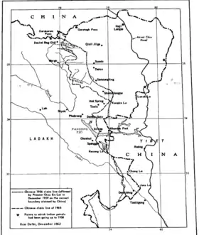
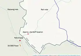
Near Burtsa, where the Depsang nala from the north and the Raki nala from the east join to form the Burtsa nala, the Line of Actual Control has been disputed by China and India.[lower-alpha 4]
China's 1956 claim line as well as the 1960 claim line leave the entire Raki nala (Tiannan river in Chinese nomenclature) in Indian territory.[9] However, the People's Liberation Army's papers are said to document a so-called "line of actual control on 7 November 1959".[10] Since 2013, they began to assert this line as the operative LAC. This would put the Chinese border within an earshot of the DS–DBO Road.[11]
In the Chinese view, the LAC claimed by India is that of 8 September 1962, prior to the hostilities of the 1962 Sino-Indian War. The area between the two lines is said to have been "unjustly occupied by India" in the intervening years.[11]
During the border standoff in 2020, the Chinese forces again stationed themselves near the junction of the Raki Nala and Depsang Nala (often called the "Y junction" or "bottleneck") and blocked the Indian troops from patrolling to the east of it. Indian media reported that this amounted to a loss of 900 square kilometres of territory for India.[12][13][14]
Construction
The construction was initiated in 2000, with a revised deadline of 2014. However, in 2011, an inquiry by the Chief Technical Examiner found that three-quarters of the road had been laid on the river bed, which is unsuitable for military use. A new Border Roads Task Force from Jammu was then commissioned to realign the constructed road on higher ground and to complete it. The revamped project was scheduled for completion in 2017 but was eventually completed in April 2019. The old alignment was used in the intervening period during the winter months.[15]
Notes
- The border is marked by the OpenStreetMap editors and may not be accurate.
- The summer caravan route is marked on the map provided by Maj. Gen. Vombatkere.[6]
- The bridge has been named after a hero of Ladakh, Chewang Rinchen, who organised the Ladakhi resistance to the Gilgit Scouts invasion during the Indo-Pakistani War of 1947. He received Maha Vir Chakra, India's second highest military honour, twice in his life time.[7]
- The terminology varies. Some writers refer to Raki nala that joins from the east as "Burtsa nala" as well. The Chinese call the river "Tiannan".
References
- Ajay Banerjee, India completes vital Ladakh road, The Tribune (Chandigarh) 22 April 2019.
- Nirupama Subramanian (16 June 2020). "Explained: The strategic road to DBO". The Indian Express.
- Lt Gen Prakash Katoch, DSDBO Road completed – but what of the scam and the northeast?, Indian Defence Review, 27 April 2019.
- Hayward, G. W. (1870), "Journey from Leh to Yarkand and Kaghgar, and Exploration of the Sources of the Yarkana River", The Journal of the Royal Geographical Society: 33
- Warikoo, K. (2009), "India's gateway to Central Asia: trans-Himalayan trade and cultural movements through Kashmir and Ladakh, 1846–1947", in Warikoo, K. (ed.), Himalayan Frontiers of India: Historical, Geo-Political and Strategic Perspectives, Routledge, p. 1, ISBN 978-1-134-03294-5: "Those traders and passersby who opted to travel to Yarkand in winter would cross Digar La and follow the narrow and winding valleys of the Shyok river. This river, which was frozen during winter, was to be crossed and re-crossed several times."
- Maj Gen S. G. Vombatkere, A Ring-Side View Of The Chinese Incursion, Countercurrents.org, 7 May 2013.
- PTI, India's Highest Altitude All-weather Permanent Bridge Inaugurated by Rajnath Singh in Eastern Ladakh, News18, 21 October 2019.
- Kapadia, Harish (2001), "The High Altitude Golf Courses", The Himalayan Journal
- Hoffmann, Steven A. (1990), India and the China Crisis, University of California Press, MAP 5. Chinese claim lines of 1956 and 1960 in the Western Sector (p. 93), ISBN 978-0-520-06537-6
- Hoffmann, Steven A. (1990), India and the China Crisis, University of California Press, MAP 6. India's forward policy, a Chinese view. (p. 105), ISBN 978-0-520-06537-6
- Yun Sun, China’s Strategic Assessment of the Ladakh Clash, War on the Rocks, 19 June 2020.
- Singh, Sushant (25 June 2020). "Closer to strategic DBO, China opens new front at Depsang". The Indian Express. Retrieved 25 June 2020.
- Swami, Praveen (24 June 2020). "As PLA Seeks to Cut Off Indian Patrol Routes on LAC, 'Bottleneck' Emerges as Roadblock in Disengagement". News18. Retrieved 26 June 2020.
- Singh, Vijaita (31 August 2020). "China controls 1,000 sq. km of area in Ladakh, say intelligence inputs". The Hindu. Retrieved 31 August 2020.
- Sushant Singh, Constructed on the riverbed, the road to China border being rebuilt, The Indian Express, 4 June 2015.
Bibliography
- Hoffmann, Steven A. (1990), India and the China Crisis, University of California Press, p. 93, ISBN 978-0-520-06537-6
External links
- Prateek Joshi, India’s Growing Military Footprint in Eastern Ladakh: Facing China, CogitAsia, Center for Strategic & International Studies, 26 July 2016.
- Alice G Wells, Why Ladakh road built last year has been a thorn in China's flesh, Economic Timems Prime, 20 May 2020.
- "Amid Ladakh standoff with China, India puts border roads in fast lane".