Leh district
Leh district is a district in the union territory of Ladakh in northern India. With an area of 45,110 km2, it is the second largest district in the country smaller only to Kutch. It is bounded on the north by Gilgit-Baltistan's Kharmang and Ghanche districts and Xinjiang's Kashgar Prefecture and Hotan Prefecture linked via the historic Karakoram Pass. It has Aksai Chin and Tibet are to the east, Kargil district to the west, and Lahul and Spiti to the south. The district headquarters is in Leh. It lies between 32 to 36 degree north latitude and 75 to 80 degree east longitude.
Leh district | |
|---|---|
.svg.png.webp) | |
| Country | |
| Union territory | Ladakh |
| Established | 1 July 1979 |
| Headquarters | Leh |
| Tehsils | Leh, Khaltsi, Nyoma, Kharu, Diskit Nubra, Saspol, Durbuk and Sumoor |
| Government | |
| • Deputy Commissioner | Sachin Kumar Vaishya |
| • Chief Executive Councillor | Tashi Gyalson, BJP |
| • Lok Sabha constituencies | Ladakh |
| Area | |
| • Total | 45,110 km2 (17,420 sq mi) |
| Population (2011) | |
| • Total | 133,487 (2,011) |
| • Urban | 45,671 |
| Demographics | |
| • Literacy | 77.2% |
| • Sex ratio | 690 |
| Time zone | UTC+05:30 (IST) |
| Website | http://leh.nic.in/ |
The whole of Ladakh was under the administration of Leh until 1 July 1979, when the Kargil and Leh administrative districts were created. Religion has been a source of grievances between Buddhists and Muslims since the late 20th century and was a contributor to this division.[1]
In 2017, the district was declared a tobacco-free zone. The Directorate of Health Services Kashmir under the National Tobacco Control Programme began working towards the designation early in 2017 and the status was declared in August. Rehana Kousar (in-charge, NTCP, Kashmir) said that work was done with civil society, religious and women's groups and that a "major success was achieved by the involvement of women in the anti-tobacco campaign."[2]
In August 2019 the Parliament of India passed an act that contained provisions to make Leh a district of the new union territory of Ladakh, which was formed 31 October 2019.[3]
Demographics
According to the 2011 census Leh district had a population of 133,487,[5][6] roughly equal to the nation of Saint Lucia.[7] This gives it a ranking of 609th in India (out of a total of 640).[5] The district has a population density of 3 inhabitants per square kilometre (7.8/sq mi). Its population growth rate over the decade 2001-2011 was 13.87%, (it was 30.15% for 1991-2001).[5] Leh has a sex ratio of 690 females for every 1000 males (this varies with religion), and a literacy rate of 77.2%.[5]
Religion
| Leh district: religion, gender ratio, and % urban of population, according to the 2011 Census.[4] | |||||||||
|---|---|---|---|---|---|---|---|---|---|
| Hindu | Muslim | Christian | Sikh | Buddhist | Jain | Other | Not stated | Total | |
| Total | 22,882 | 19,057 | 658 | 1,092 | 88,635 | 103 | 54 | 1,006 | 133,487 |
| 17.14% | 14.28% | 0.49% | 0.82% | 66.40% | 0.08% | 0.04% | 0.75% | 100.00% | |
| Male | 21,958 | 10,493 | 469 | 1,018 | 44,019 | 49 | 29 | 936 | 78,971 |
| Female | 924 | 8,564 | 189 | 74 | 44,616 | 54 | 25 | 70 | 54,516 |
| Gender ratio (% female) | 4.0% | 44.9% | 28.7% | 6.8% | 50.3% | 52.4% | 46.3% | 7.0% | 40.8% |
| Sex ratio (no. females per 1,000 males) |
42 | 816 | 403 | 73 | 1,014 | – | – | 75 | 690 |
| Urban | 14,542 | 5,169 | 358 | 927 | 24,023 | 24 | 53 | 575 | 45,671 |
| Rural | 8,340 | 13,888 | 300 | 165 | 64,612 | 79 | 1 | 431 | 87,816 |
| % Urban | 63.6% | 27.1% | 54.4% | 84.9% | 27.1% | 23.3% | 98.1% | 57.2% | 34.2% |
Languages
Leh district: mother-tongue of population, according to the 2011 Census.[9]
| Leh district: mother-tongue of population, according to the 2011 Census.[9] | |||
|---|---|---|---|
| Mother tongue code | Mother tongue | People | Percentage |
| 001002 | Assamese | 281 | 0.21% |
| 002007 | Bengali | 808 | 0.61% |
| 004001 | Dogri | 896 | 0.67% |
| 005018 | Gujarati | 302 | 0.23% |
| 006086 | Bhadrawahi | 7 | 0.01% |
| 006102 | Bhojpuri | 149 | 0.11% |
| 006195 | Garhwali | 101 | 0.08% |
| 006207 | Gojri/Gujjari/Gujar | 123 | 0.09% |
| 006235 | Haryanvi | 70 | 0.05% |
| 006240 | Hindi | 17,017 | 12.75% |
| 006291 | Kangri | 7 | 0.01% |
| 006340 | Kumauni | 65 | 0.05% |
| 006394 | Mandeali | 7 | 0.01% |
| 006400 | Marwari | 7 | 0.01% |
| 006439 | Pahari | 168 | 0.13% |
| 006489 | Rajasthani | 92 | 0.07% |
| 007016 | Kannada | 367 | 0.27% |
| 008005 | Kashmiri | 521 | 0.39% |
| 008010 | Kishtwari | 17 | 0.01% |
| 008019 | Dardi | 21 | 0.02% |
| 010008 | Maithili | 19 | 0.01% |
| 011016 | Malayalam | 607 | 0.45% |
| 012003 | Manipuri | 60 | 0.04% |
| 013071 | Marathi | 1,349 | 1.01% |
| 014011 | Nepali | 1,349 | 1.01% |
| 015043 | Odia | 449 | 0.34% |
| 016002 | Bagri | 14 | 0.01% |
| 016038 | Punjabi | 1,336 | 1.00% |
| 020027 | Tamil | 725 | 0.54% |
| 021046 | Telugu | 793 | 0.59% |
| 022015 | Urdu | 158 | 0.12% |
| 029002 | Balti | 5,269 | 3.95% |
| 031001 | Bhotia | 320 | 0.24% |
| 031011 | Bauti | 89,319 | 66.91% |
| 040001 | English | 26 | 0.02% |
| 053005 | Gujari | 31 | 0.02% |
| 073003 | Ladakhi | 4,416 | 3.31% |
| 082005 | Lushai/Mizo | 8 | 0.01% |
| 108001 | Sherpa | 21 | 0.02% |
| 111001 | Tamang | 18 | 0.01% |
| 115008 | Tibetan | 4,623 | 3.46% |
| 115011 | Purkhi | 160 | 0.12% |
| – | Others | 1,391 | 1.04% |
| Total | 133,487 | 100.00% | |
Administration
As a result of The Jammu and Kashmir Reorganisation (Removal of Difficulties) Second Order, 2019, Leh district would claim de jure jurisdiction over the following areas of Pakistani-administered Kashmir: Gilgit, Gilgit Wazarat, Chilas and Tribal territory.[10]
The Ladakh Autonomous Hill Development Council, Leh(LAHDC Leh), is the Autonomous District Council that administers the Leh district.[11]
As of July 2019, Leh district is divided into 6 sub-divisions, 8 tehsils and 16 blocks.[12][13]
There are eight tehsils: Leh, Khaltsi (Khalsi), Nyoma, Kharu, Diskit in Nubra Valley, Saspol (Suspol), Durbuk (Durbok), Sumoor.[13]
Politics
Parliamentary Constituency
The district falls under Ladakh (Lok Sabha constituency).
Assembly constituencies
Leh District had two assembly constituencies: Nobra and Leh.[15]
Autonomous Hill Council
Leh District is administered by an elected body known as the Ladakh Autonomous Hill Development Council, Leh. The LAHDC was established in 1995.[16]
The latest elections were held in October 2020. The BJP secured 15 seats while the INC won 9 and the Independents won 2.
Gallery
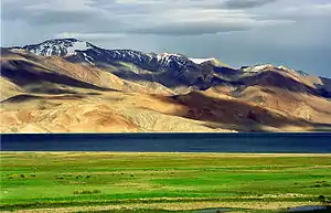 Tsomoriri lake
.jpg.webp) Leh district flower fields and mountains
Leh district flower fields and mountains
References
- "Muslim Precedence Politics - How it operates in Ladakh". Kashmir Sentinel. August 2002. Archived from the original on 6 October 2008.
- "Leh Declared Tobacco-Free". The Tribune India. Retrieved 24 August 2017.
- "Article 370 revoked Updates: Jammu & Kashmir is now a Union Territory, Lok Sabha passes bifurcation bill". Business Today. 6 August 2019.
- C-1 Population By Religious Community – Jammu & Kashmir (Report). Office of the Registrar General & Census Commissioner, India. Retrieved 28 July 2020.
- "District Census 2011". Census2011.co.in. 2011. Retrieved 30 September 2011.
- "Leh district census data 2011" (PDF). Retrieved 20 February 2019.
- US Directorate of Intelligence. "Country Comparison:Population". Retrieved 1 October 2011.
Saint Lucia 161,557 July 2011 est.
- "Leh District Population Census 2011-2020, Jammu and Kashmir literacy sex ratio and density".
- C-16 Population By Mother Tongue – Jammu & Kashmir (Report). Office of the Registrar General & Census Commissioner, India. Retrieved 18 July 2020.
- "J&K Reorganisation (Removal of Difficulties) Second Order, 2019 -- [Territory of Leh district shall constitute, Gilgit, Gilgit Wazarat, Chilas, Tribal territory & 'Leh & Ladakh' except present territory of Kargil]". 2 November 2019.
- "Ladakh Autonomous Hill development Council act 1997" (PDF). Retrieved 26 January 2021.
- "Subdivisions & Blocks". District Leh - Ladakh.
- Leh tehsils.
- "Villages | District Leh, Union Territory of Ladakh | India". District Leh - Ladakh – Government of India. Archived from the original on 24 December 2020. Retrieved 24 December 2020.
- "ERO's and AERO's". Chief Electoral Officer, Jammu and Kashmir. Archived from the original on 22 October 2008. Retrieved 28 August 2008.
- "Ladakh Autonomous Hill Development Council, Leh". Leh. Archived from the original on 30 October 2007. Retrieved 6 December 2007.
External links
| Wikimedia Commons has media related to Leh district. |
- Official Website of Ladakh Autonomous Hill Development Council, Leh
- Leh tehsil map, Maps of India
- Ladakh Tourism Guide - Photo Gallery of Leh, Monasteries in Leh, NGO's in Leh, Important Phone #.
- Shaam Region in Leh (not to be confused with the Middle Eastern region)
Places adjacent to Leh district | |
|---|---|
| History |
| ||||||||||||||||||
|---|---|---|---|---|---|---|---|---|---|---|---|---|---|---|---|---|---|---|---|
| Administration | |||||||||||||||||||
| Geography |
| ||||||||||||||||||
| Human settlements | |||||||||||||||||||
| Culture |
| ||||||||||||||||||
| Tourism and wildlife |
| ||||||||||||||||||
| Transport |
| ||||||||||||||||||
| Infrastructure |
| ||||||||||||||||||
| See also |
| ||||||||||||||||||