Department of Cuzco
Cusco, also spelled Cuzco (Spanish pronunciation: [ˈkusko]; Quechua: Qusqu suyu [ˈqɔsqɔ ˈsʊjʊ]), is a department in Peru and is the fourth largest department in the country, after Madre de Dios, Ucayali, and Loreto. It borders the departments of Ucayali on the north; Madre de Dios and Puno on the east; Arequipa on the south; and Apurímac, Ayacucho and Junín on the west. Its capital is Cusco, the historical capital of the Inca Empire.[2]
Cuzco Department | |
|---|---|
 Machu Picchu, the lost city of the Inca | |
 Flag  Seal | |
.svg.png.webp) Location of the Department of Cusco in Peru | |
| Coordinates: 13.26°S 72.11°W | |
| Country | Peru |
| Subdivisions | 13 provinces and 108 districts |
| Largest city | Cusco |
| Capital | Cusco |
| Government | |
| • Governor | Jean Paul Benavente García [1] |
| Area | |
| • Total | 71,986 km2 (27,794 sq mi) |
| Elevation (Capital) | 3,399 m (11,152 ft) |
| Highest elevation | 4,801 m (15,751 ft) |
| Lowest elevation | 532 m (1,745 ft) |
| Population (2017) | |
| • Total | 1,205,527 |
| • Density | 17/km2 (43/sq mi) |
| UBIGEO | 08 |
| Dialing code | 0484 |
| ISO 3166 code | PE-CUS |
| Principal resources | Gold, maize, barley, quinoa, and tea |
| Poverty rate | 52.3% |
| Percentage of Peru's GDP | 4.4% |
| Website | www.regioncusco.gob.pe/ |

Geography
The plain of Anta contains some of the best communal cultivated lands of the Department of Cusco. It is located about 3,000 metres (9,800 ft) above sea level and is used to cultivate mainly high altitude crops such as potatoes, tarwi (edible lupin), barley and quinoa.
Provinces
- Acomayo (Acomayo)
- Anta (Anta)
- Calca (Calca)
- Canas (Yanaoca)
- Canchis (Sicuani)
- Chumbivilcas (Santo Tomás)
- Cusco (Cusco)
- Espinar (Yauri)
- La Convención (Quillabamba)
- Paruro (Paruro)
- Paucartambo (Paucartambo)
- Quispicanchi (Urcos)
- Urubamba (Urubamba)
Languages
According to the 2007 Peru Census, the language learnt first by most of the residents was Quechua (51.40%), followed by Spanish (46.86%). The Quechua variety spoken in this department is Cusco Quechua.
The following table shows the results concerning the language learnt first in the Department of Cusco by province:[3]
| Province | Quechua | Aymara | Asháninka | Another native language | Spanish | Foreign language | Deaf or mute | Total |
|---|---|---|---|---|---|---|---|---|
| Acomayo | 22,262 | 12 | 2 | 4 | 3,117 | - | 52 | 25,449 |
| Anta | 36,512 | 42 | 3 | 10 | 15,248 | 8 | 132 | 51,955 |
| Calca | 43,008 | 101 | 4 | 117 | 18,128 | 13 | 142 | 61,513 |
| Canas | 32,790 | 31 | 6 | 11 | 2,910 | - | 40 | 35,788 |
| Canchis | 53,695 | 107 | 5 | 7 | 37,702 | 2 | 120 | 91,638 |
| Chumbivilcas | 64,087 | 102 | 9 | 1 | 6,063 | 2 | 104 | 70,368 |
| Cusco | 63,675 | 781 | 94 | 306 | 282,610 | 1,521 | 466 | 349,453 |
| Espinar | 40,594 | 120 | 8 | 1 | 18,116 | 6 | 71 | 58,916 |
| La Convención | 62,145 | 276 | 2,802 | 9,278 | 81,111 | 120 | 318 | 156,050 |
| Paruro | 26,707 | 53 | 5 | 1 | 2,192 | 1 | 42 | 29,001 |
| Paucartambo | 35,996 | 95 | 15 | 207 | 5,682 | 9 | 65 | 42,069 |
| Quispicanchi | 57,587 | 152 | 11 | 12 | 18,562 | 20 | 86 | 76,430 |
| Urubamba | 27,523 | 104 | 4 | 9 | 25,075 | 823 | 68 | 53,606 |
| Total | 566,581 | 1,976 | 2,968 | 9,964 | 516,516 | 2,525 | 1,706 | 1,102,236 |
| % | 51.40 | 0.18 | 0.27 | 0.90 | 46.86 | 0.23 | 0.15 | 100.00 |
Toponyms
Many of the toponyms of the Department of Cusco originate from Quechua and also Aymara. These names are overwhelmingly predominant throughout the region. Their Spanish-based orthography, however, is in conflict with the normalised alphabets of these languages. According to Article 20 of Decreto Supremo No 004-2016-MC (Supreme Decree) which approves the Regulations to Law 29735, published in the official newspaper El Peruano on July 22, 2016, adequate spellings of the toponyms in the normalised alphabets of the indigenous languages must progressively be proposed with the aim of standardising the naming used by the National Geographic Institute (Instituto Geográfico Nacional, IGN) The National Geographic Institute realises the necessary changes in the official maps of Peru.[4]
The Ministry of Culture additionally proposes to the municipalities of the provinces to recover ancient indigenous toponyms and that these names should be spread by the local and communal authorities on posters and other signage.[4]
Gallery
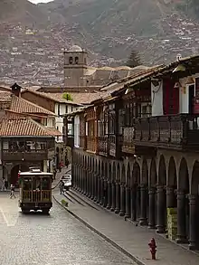 Balconies and arcades at the main square in Cusco
See also
Sources
- "Gobernador Regional del Cusco". Gobierno Regional del Cusco. Gobierno Regional del Cusco. Retrieved 8 February 2019.
- Official page (in Spanish)
- inei.gob.pe Archived January 27, 2013, at the Wayback Machine INEI, Peru, Censos Nacionales 2007
- "Decreto Supremo que aprueba el Reglamento de la Ley N° 29735, Ley que regula el uso, preservación, desarrollo, recuperación, fomento y difusión de las lenguas originarias del Perú, Decreto Supremo N° 004-2016-MC". Retrieved July 17, 2017.