Derby, Indiana
Derby is an unincorporated community along the Ohio River in far southern Union Township, Perry County, in the U.S. state of Indiana.[2] It lies at the intersection of State Roads 66 and 70 above the city of Tell City, the county seat of Perry County.[3] Its elevation is 453 feet (138 m), and it is located at 38°1′49″N 86°31′38″W (38.0303400, -86.5272018). Although Derby is unincorporated, it has a post office, with the ZIP code of 47525.[4]
Derby, Indiana | |
|---|---|
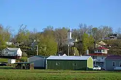 Overview from Mulzer Park | |
 Derby, Indiana  Derby, Indiana | |
| Coordinates: 38°1′49″N 86°31′38″W | |
| Country | United States |
| State | Indiana |
| County | Perry |
| Township | Union |
| Elevation | 453 ft (138 m) |
| Time zone | UTC-6 (Central (CST)) |
| • Summer (DST) | UTC-5 (CDT) |
| ZIP code | 47525 |
| Area code(s) | 812, 930 |
| GNIS feature ID | 450842 |
History
Derby was platted in 1835.[5] The community was named after Derby, in Ireland.[6] A post office has been in operation at Derby since 1852.[7]
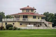
Photo from Small Town Indiana photo survey.
References
- "US Board on Geographic Names". United States Geological Survey. October 25, 2007. Retrieved 2017-04-15.
- "Derby, Indiana". Geographic Names Information System. United States Geological Survey. Retrieved 2009-10-10.
- DeLorme. Indiana Atlas & Gazetteer. 3rd ed. Yarmouth: DeLorme, 2004, p. 62-63. ISBN 0-89933-319-2.
- Zip Code Lookup
- Hunt, Thomas James De la (1916). Perry County: A History. W.K. Stewart. p. 82.
- Baker, Ronald L. (October 1995). From Needmore to Prosperity: Hoosier Place Names in Folklore and History. Indiana University Press. p. 113. ISBN 978-0-253-32866-3.
...for Derby, Ireland, the home of his ancestors.
- "Perry County". Jim Forte Postal History. Retrieved 2 October 2015.
Municipalities and communities of Perry County, Indiana, United States | ||
|---|---|---|
| Cities | Map of Indiana highlighting Perry County | |
| Town | ||
| Townships | ||
| Unincorporated communities | ||
| ||
This article is issued from Wikipedia. The text is licensed under Creative Commons - Attribution - Sharealike. Additional terms may apply for the media files.