Desborough Cut
The Desborough Cut is an artificial channel in the River Thames above Sunbury Lock near Walton on Thames in England. It was completed in 1935, to improve flow and ease navigation on the river.
| Desborough Island and Cut map | ||||||||||||||||||||||||||||||||||||||||||||||||||||||||||||||||||||||||
|---|---|---|---|---|---|---|---|---|---|---|---|---|---|---|---|---|---|---|---|---|---|---|---|---|---|---|---|---|---|---|---|---|---|---|---|---|---|---|---|---|---|---|---|---|---|---|---|---|---|---|---|---|---|---|---|---|---|---|---|---|---|---|---|---|---|---|---|---|---|---|---|---|
| ||||||||||||||||||||||||||||||||||||||||||||||||||||||||||||||||||||||||
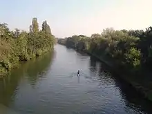
The cut was dug between 1930 and 1935, taking the river on a straight course between Weybridge and Walton, and avoiding a meandering stretch past Shepperton and Lower Halliford.[1] It is a very slight curve 1,093 metres (1,195 yd) long. Its geodesic length is 1,084 metres (1,185 yd) as the crow flies, and its construction created Desborough Island. Two bridges were built across the cut to link to the island, which contains a water treatment works and a large extent of open space used for recreation. The cut alleviated flooding in Shepperton[2] and halved the distance of travel on that part of the river.
The cut creates a rare stretch on the Thames having alternative main navigation channels and is the longest such alternative. Navigation transit markers stand alongside it as a traditional method for powered boats to check their speed.
The cut and the adjacent island were named after Lord Desborough who was chairman of the Thames Conservancy at the time and who opened it.[3]
References
- "The Hundred of Spelthorne: Shepperton". Archived from the original on 4 January 2011. Retrieved 24 February 2009.
- Shepperton Rotary Club Archived 2011-10-06 at the Wayback Machine
- Ron Emmons Walks along the Thames Path New Holland Publishers 2008
| Towns, villages and localities | 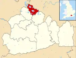 | ||||||
|---|---|---|---|---|---|---|---|
| Key parks | |||||||
| Large listed buildings |
| ||||||
| Education | |||||||
| Railway stations | |||||||
| Buildings and structures | |||||||
| Sport |
| ||||||
| Destroyed landmarks | |||||||