Dourdou de Camarès
The Dourdou de Camarès is an 86.8 km (53.9 mi) long river in the Tarn, Hérault and Aveyron departments in southern France.[1] Its source is in the Parc naturel régional du Haut-Languedoc, in the commune of Murat-sur-Vèbre, 5.5 km (3.4 mi) southeast of the village. It flows generally northwest. It is a left tributary of the Tarn into which it flows at Broquiès, 1.2 km (0.75 mi) southwest of the village.
| Dourdou de Camarès | |
|---|---|
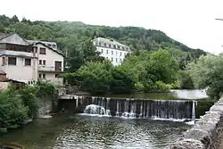 The Dourdou at Brusque | |
| Location | |
| Country | France |
| Region | Occitanie |
| Physical characteristics | |
| Source | |
| • location | in Murat-sur-Vèbre |
| • coordinates | 43°39′19″N 02°54′30″E |
| • elevation | 1,079 m (3,540 ft) |
| Mouth | |
• location | Tarn |
• coordinates | 43°59′47″N 02°41′05″E |
• elevation | 245 m (804 ft) |
| Length | 86.8 km (53.9 mi) |
| Basin size | 658 km2 (254 sq mi) |
| Discharge | |
| • average | 12.1 m3/s (430 cu ft/s) |
| Basin features | |
| Progression | Tarn→ Garonne→ Gironde estuary→ Atlantic Ocean |
Its main tributary is the Sorgues.
Departments and communes along its course
The following list is ordered from source to mouth :
- Tarn: Murat-sur-Vèbre
- Hérault: Castanet-le-Haut
- Aveyron: Arnac-sur-Dourdou, Brusque, Fayet, Sylvanès, Camarès, Montlaur, Vabres-l'Abbaye, Saint-Affrique, Calmels-et-le-Viala, Saint-Izaire, Broquiès
Notes
| Wikimedia Commons has media related to Dourdou de Camarès. |
- This article is based on the equivalent article from the French Wikipedia, consulted on January 28th 2009.
This article is issued from Wikipedia. The text is licensed under Creative Commons - Attribution - Sharealike. Additional terms may apply for the media files.