Arnac-sur-Dourdou
Arnac-sur-Dourdou (Occitan: Arnac) is a commune in the Aveyron department in the Occitanie region of southern France.
Arnac-sur-Dourdou | |
|---|---|
 Old bread oven | |
Location of Arnac-sur-Dourdou 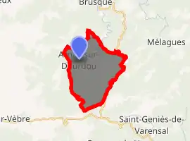
| |
 Arnac-sur-Dourdou  Arnac-sur-Dourdou | |
| Coordinates: 43°43′38″N 2°56′00″E | |
| Country | France |
| Region | Occitanie |
| Department | Aveyron |
| Arrondissement | Millau |
| Canton | Causses-Rougiers |
| Intercommunality | Monts, Rance et Rougier |
| Government | |
| • Mayor (2014-2020) | Fernande Singer |
| Area 1 | 16.57 km2 (6.40 sq mi) |
| Population (2017-01-01)[1] | 34 |
| • Density | 2.1/km2 (5.3/sq mi) |
| Time zone | UTC+01:00 (CET) |
| • Summer (DST) | UTC+02:00 (CEST) |
| INSEE/Postal code | 12009 /12360 |
| Elevation | 506–1,000 m (1,660–3,281 ft) (avg. 560 m or 1,840 ft) |
| 1 French Land Register data, which excludes lakes, ponds, glaciers > 1 km2 (0.386 sq mi or 247 acres) and river estuaries. | |
The inhabitants of the commune are known as Arnacois or Arnacoises[2]
Geography
Arnac-sur-Dourdou is a sparsely populated commune in the extreme southern corner of Aveyron some 50 km west by north-west of Saint-André-de-Sangonis and 8 km east by north-east of Murat-sur-Vèbre in the heart of the Lacaune mountains. The western border of the commune is also the border between the departments of Aveyron and Tarn while the southern border is the border between Aveyron and Hérault. Access to the commune is by the D92 road from Brusque in the north which is a tortuous mountain road going to the village and continuing west to change to the D162 at the commune border then south to join the D622 to Murat-sur-Vèbre. The D12 road from Brusque to the south forms the eastern border of the commune and road D174 connects the village to this road. The commune is mountainous and heavily forested.[3]
The Dourdou de Camarès river flows through the commune and the village from east to west gathering numerous tributaries flowing from all corners of the commune.[3]
Neighbouring communes and villages
Places adjacent to Arnac-sur-Dourdou | |
|---|---|
History
Until the French Revolution the Parish of Arnac was part of the community of Brusque. Saint-Benoît-d'Arnac was then an annex of the Parish of Saint-Pierre-des-Cats (currently the commune of Mélagues). After the Revolution Arnac was part of the commune of Mélagues. It was in 1872 that the commune of Arnac-sur-Dourdou was founded. Today the village consists of many second homes which are often the properties of descendants of the past inhabitants of the village.
Administration
List of Successive Mayors[4]
| From | To | Name | Party | Position |
|---|---|---|---|---|
| 1872 | 1892 | Barthélémy Garenq | ||
| 1892 | 1929 | Jacques Roques | ||
| 1929 | 1935 | Hyppolyte Garenq | ||
| 1935 | 1945 | Jacques Roques | ||
| 1945 | 1947 | Jean Bertrand | ||
| 1947 | 1995 | Louis Maury | ||
| 1995 | 1997 | Pierre Garrencq | ||
| 1997 | 2008 | Henri Riac | ||
| 2008 | Current | Fernande Singer | DVG |
(Not all data is known)
Population
| Year | Pop. | ±% |
|---|---|---|
| 2006 | 24 | — |
| 2007 | 23 | −4.2% |
| 2008 | 23 | +0.0% |
| 2009 | 23 | +0.0% |
| 2010 | 27 | +17.4% |
| 2011 | 32 | +18.5% |
| 2012 | 37 | +15.6% |
| 2013 | 37 | +0.0% |
| 2014 | 38 | +2.7% |
| 2015 | 36 | −5.3% |
| 2016 | 35 | −2.8% |
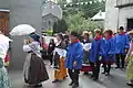
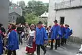
Cultural Events and Festivals
- Arnac Festival in traditional clothes


Sites and monuments
- The Church of Saint-Benoît
- The Bread oven at the Arnac Mill
- The GR 71 passes through the commune
 Church of Saint-Benoît.
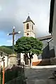 Church of Saint-Benoît.
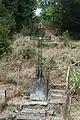 Wayside Cross.
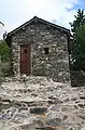 The bread oven in the Mill of Arnac.
See also
Bibliography
- Christian-Pierre Bedel, Lo Pont - Arnac, Brusca, Faiet, Gissac, Melagas, Montanhòl, Pèus-e-Cofolèus, Silvanés, Tauriac, preface by the General Counsel, Christian-Pierre Bedel e los estatjants del canton de Camarés, Rodez, Mission départementale de la culture, 2000, Al canton collection, 320 pages, ill., cover ill., 28 cm, ISBN 2-907279-50-5, ISSN 1151-8375, BNF 37657611d (Occitan/French)
External links
- Arnac-sur-Dourdou on Lion1906
- Arnac-sur-Dourdou on Géoportail, National Geographic Institute (IGN) website (in French)
- Arnac on the 1750 Cassini Map
Notes and references
Notes
References
- "Populations légales 2017". INSEE. Retrieved 6 January 2020.
- Inhabitants of Aveyron (in French)
- Google Maps
- List of Mayors of France (in French)
| Wikimedia Commons has media related to Arnac-sur-Dourdou. |
| Authority control |
|---|