Dow City, Iowa
Dow City is a city in Crawford County, Iowa, United States, along the Boyer River. The population was 510 at the 2010 census.
Dow City, Iowa | |
|---|---|
 | |
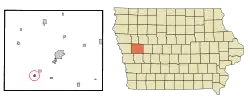 Location of Dow City, Iowa | |
| Coordinates: 41°55′42″N 95°29′40″W | |
| Country | |
| State | |
| County | Crawford |
| Area | |
| • Total | 0.32 sq mi (0.83 km2) |
| • Land | 0.32 sq mi (0.83 km2) |
| • Water | 0.00 sq mi (0.00 km2) |
| Elevation | 1,142 ft (348 m) |
| Population | |
| • Total | 510 |
| • Estimate (2019)[3] | 497 |
| • Density | 1,557.99/sq mi (600.67/km2) |
| Time zone | UTC-6 (Central (CST)) |
| • Summer (DST) | UTC-5 (CDT) |
| ZIP code | 51528 |
| Area code(s) | 712 |
| FIPS code | 19-22215 |
| GNIS feature ID | 0455969 |
History
Judge S. E. Dow settled at what is now Dow City in 1855. In 1869, he laid out the town in anticipation of the railroad being built through the settlement. The railroad depot was built in 1870.[4]
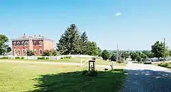
Dow City is the location of the historic Dow House, which was built in 1872.[5]
Geography
Dow City is located at 41°55′42″N 95°29′40″W (41.928195, -95.494475).[6]
According to the United States Census Bureau, the city has a total area of 0.32 square miles (0.83 km2), all land.[7]
Dow City is located on U.S. Route 30 and is thirty miles north of Interstate 80.
Demographics
| Year | Pop. | ±% |
|---|---|---|
| 1880 | 291 | — |
| 1890 | 451 | +55.0% |
| 1900 | 462 | +2.4% |
| 1910 | 462 | +0.0% |
| 1920 | 572 | +23.8% |
| 1930 | 588 | +2.8% |
| 1940 | 642 | +9.2% |
| 1950 | 524 | −18.4% |
| 1960 | 531 | +1.3% |
| 1970 | 571 | +7.5% |
| 1980 | 616 | +7.9% |
| 1990 | 439 | −28.7% |
| 2000 | 503 | +14.6% |
| 2010 | 510 | +1.4% |
| 2019 | 497 | −2.5% |
| Source:"U.S. Census website". United States Census Bureau. Retrieved 2020-03-29. and Iowa Data Center Source: | ||
2010 census
As of the census[2] of 2010, there were 510 people, 219 households, and 137 families living in the city. The population density was 1,593.8 inhabitants per square mile (615.4/km2). There were 242 housing units at an average density of 756.3 per square mile (292.0/km2). The racial makeup of the city was 93.1% White, 0.2% Native American, 6.1% from other races, and 0.6% from two or more races. Hispanic or Latino of any race were 9.0% of the population.
There were 219 households, of which 28.3% had children under the age of 18 living with them, 48.4% were married couples living together, 9.1% had a female householder with no husband present, 5.0% had a male householder with no wife present, and 37.4% were non-families. 31.5% of all households were made up of individuals, and 16% had someone living alone who was 65 years of age or older. The average household size was 2.33 and the average family size was 2.95.
The median age in the city was 42.4 years. 24.1% of residents were under the age of 18; 7% were between the ages of 18 and 24; 21.4% were from 25 to 44; 28.3% were from 45 to 64; and 19.4% were 65 years of age or older. The gender makeup of the city was 50.4% male and 49.6% female.
2000 census
As of the census[9] of 2000, there were 503 people, 227 households, and 142 families living in the city. The population density was 1,578.3 people per square mile (606.9/km2). There were 248 housing units at an average density of 778.2 per square mile (299.2/km2). The racial makeup of the city was 96.82% White, 1.19% Asian, 1.19% from other races, and 0.80% from two or more races. Hispanic or Latino of any race were 1.59% of the population.
There were 227 households, out of which 23.3% had children under the age of 18 living with them, 50.2% were married couples living together, 7.5% had a female householder with no husband present, and 37.4% were non-families. 31.3% of all households were made up of individuals, and 14.1% had someone living alone who was 65 years of age or older. The average household size was 2.22 and the average family size was 2.75.
In the city, the population was spread out, with 19.5% under the age of 18, 8.3% from 18 to 24, 24.1% from 25 to 44, 26.4% from 45 to 64, and 21.7% who were 65 years of age or older. The median age was 44 years. For every 100 females, there were 100.4 males. For every 100 females age 18 and over, there were 91.0 males.
The median income for a household in the city was $30,547, and the median income for a family was $37,813. Males had a median income of $30,104 versus $17,000 for females. The per capita income for the city was $18,108. About 2.9% of families and 8.0% of the population were below the poverty line, including 4.3% of those under age 18 and 10.0% of those age 65 or over.
Education
Boyer Valley Community School District operates public schools serving the community.[10] It was a part of the Dow City-Arion Community School District until July 1, 1994, when it merged into the Boyer Valley district.[11]
Notable person
- Arthur Bowring, rancher and legislator[12]
References
- "2019 U.S. Gazetteer Files". United States Census Bureau. Retrieved July 17, 2020.
- "U.S. Census website". United States Census Bureau. Retrieved 2012-05-11.
- "Population and Housing Unit Estimates". United States Census Bureau. May 24, 2020. Retrieved May 27, 2020.
- History of Western Iowa, Its Settlement and Growth. Western Publishing Company. 1882. p. 483.
- Crawford County Conservation Board listing for Dow House
- "US Gazetteer files: 2010, 2000, and 1990". United States Census Bureau. 2011-02-12. Retrieved 2011-04-23.
- "US Gazetteer files 2010". United States Census Bureau. Archived from the original on 2012-07-02. Retrieved 2012-05-11.
- "Census of Population and Housing". Census.gov. Retrieved June 4, 2015.
- "U.S. Census website". United States Census Bureau. Retrieved 2008-01-31.
- "Boyer Valley." Iowa Department of Education. Retrieved on July 16, 2018.
- "REORGANIZATION & DISSOLUTION ACTIONS SINCE 1965-66." Iowa Department of Education. Retrieved on July 20, 2018.
- 'Nebraska Blue Book 1932,' Biographical Sketch of Arthur Bowring, pg 270
Municipalities and communities of Crawford County, Iowa, United States | ||
|---|---|---|
| Cities | Map of Iowa highlighting Crawford County | |
| Townships | ||
| Unincorporated communities | ||
| Footnotes | ‡This populated place also has portions in an adjacent county or counties | |
| ||
| Authority control |
|---|
