Du Bois, Nebraska
Du Bois(/du.ˈbɔɪz/ doo-BOYZ) [6] is a village in the southeast corner of Pawnee County, Nebraska, United States. The population was 147 at the 2010 census.
Du Bois, Nebraska | |
|---|---|
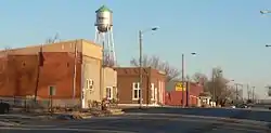 Downtown DuBois | |
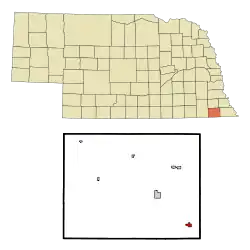 Location of Du Bois, Nebraska | |
| Coordinates: 40°2′2″N 96°2′56″W | |
| Country | United States |
| State | Nebraska |
| County | Pawnee |
| Area | |
| • Total | 0.45 sq mi (1.18 km2) |
| • Land | 0.45 sq mi (1.18 km2) |
| • Water | 0.00 sq mi (0.00 km2) |
| Elevation | 1,066 ft (325 m) |
| Population | |
| • Total | 147 |
| • Estimate (2019)[3] | 137 |
| • Density | 301.76/sq mi (116.48/km2) |
| Time zone | UTC-6 (Central (CST)) |
| • Summer (DST) | UTC-5 (CDT) |
| ZIP code | 68345 |
| Area code(s) | 402 |
| FIPS code | 31-13750[4] |
| GNIS feature ID | 0835291[5] |
History
Du Bois was platted in 1886 when the railroad was extended to that point.[7] It was named for Captain Charles J. DuBois, a railroad official.[8]
Geography
According to the United States Census Bureau, the village has a total area of 0.45 square miles (1.17 km2), all land.[9]
Demographics
| Historical population | |||
|---|---|---|---|
| Census | Pop. | %± | |
| 1890 | 316 | — | |
| 1900 | 307 | −2.8% | |
| 1910 | 339 | 10.4% | |
| 1920 | 332 | −2.1% | |
| 1930 | 350 | 5.4% | |
| 1940 | 315 | −10.0% | |
| 1950 | 236 | −25.1% | |
| 1960 | 218 | −7.6% | |
| 1970 | 185 | −15.1% | |
| 1980 | 178 | −3.8% | |
| 1990 | 119 | −33.1% | |
| 2000 | 166 | 39.5% | |
| 2010 | 147 | −11.4% | |
| 2019 (est.) | 137 | [3] | −6.8% |
| U.S. Decennial Census[10] | |||
2010 census
As of the census[2] of 2010, there were 147 people, 66 households, and 39 families residing in the village. The population density was 326.7 inhabitants per square mile (126.1/km2). There were 84 housing units at an average density of 186.7 per square mile (72.1/km2). The racial makeup of the village was 92.5% White, 4.1% from other races, and 3.4% from two or more races. Hispanic or Latino of any race were 4.1% of the population.
There were 66 households, of which 25.8% had children under the age of 18 living with them, 51.5% were married couples living together, 3.0% had a female householder with no husband present, 4.5% had a male householder with no wife present, and 40.9% were non-families. 34.8% of all households were made up of individuals, and 18.2% had someone living alone who was 65 years of age or older. The average household size was 2.23 and the average family size was 2.92.
The median age in the village was 49.2 years. 21.8% of residents were under the age of 18; 2.6% were between the ages of 18 and 24; 19.7% were from 25 to 44; 29.9% were from 45 to 64; and 25.9% were 65 years of age or older. The gender makeup of the village was 53.7% male and 46.3% female.
2000 census
As of the census[4] of 2000, there were 166 people, 76 households, and 44 families residing in the village. The population density was 364.1 people per square mile (139.3/km2). There were 87 housing units at an average density of 190.8 per square mile (73.0/km2). The racial makeup of the village was 98.19% White, and 1.81% from two or more races.
There were 76 households, out of which 21.1% had children under the age of 18 living with them, 50.0% were married couples living together, 5.3% had a female householder with no husband present, and 42.1% were non-families. 35.5% of all households were made up of individuals, and 22.4% had someone living alone who was 65 years of age or older. The average household size was 2.18 and the average family size was 2.89.
In the village, the population was spread out, with 22.3% under the age of 18, 2.4% from 18 to 24, 24.1% from 25 to 44, 26.5% from 45 to 64, and 24.7% who were 65 years of age or older. The median age was 48 years. For every 100 females, there were 97.6 males. For every 100 females age 18 and over, there were 98.5 males.
As of 2000 the median income for a household in the village was $26,250, and the median income for a family was $33,125. Males had a median income of $23,000 versus $14,375 for females. The per capita income for the village was $10,335. About 6.1% of families and 11.3% of the population were below the poverty line, including 11.8% of those under the age of eighteen and 25.9% of those 65 or over.
References
- "2019 U.S. Gazetteer Files". United States Census Bureau. Retrieved July 26, 2020.
- "U.S. Census website". United States Census Bureau. Retrieved 2012-06-24.
- "Population and Housing Unit Estimates". United States Census Bureau. May 24, 2020. Retrieved May 27, 2020.
- "U.S. Census website". United States Census Bureau. Retrieved 2008-01-31.
- "US Board on Geographic Names". United States Geological Survey. 2007-10-25. Retrieved 2008-01-31.
- "DuBois". PawneeCountyNebraska.com. Retrieved 2016-10-14.
- "Du Bois, Pawnee County". Center for Advanced Land Management Information Technologies. University of Nebraska. Retrieved 21 August 2014.
- "Du Bois". Pawnee County Promotional Network. Retrieved 21 August 2014.
- "US Gazetteer files 2010". United States Census Bureau. Archived from the original on 2012-07-02. Retrieved 2012-06-24.
- "Census of Population and Housing". Census.gov. Retrieved June 4, 2015.
Municipalities and communities of Pawnee County, Nebraska, United States | ||
|---|---|---|
| City | Map of Nebraska highlighting Pawnee County | |
| Villages | ||
| Unincorporated communities | ||
| Ghost town | ||
| ||
| Authority control |
|---|