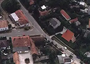
Dunafalva
Dunafalva (Croatian: Topolovac) is a village and municipality in Bács-Kiskun county, in the Southern Great Plain region of southern Hungary.
Dunafalva
Contra Florentiam (in Latin) | |
|---|---|
 | |
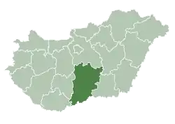
 Dunafalva Location of Dunafalva | |
| Coordinates: 46.0833°N 18.7833°E | |
| Country | |
| County | Bács-Kiskun |
| Area | |
| • Total | 57.89 km2 (22.35 sq mi) |
| Population (2015) | |
| • Total | 905[1] |
| • Density | 15.6/km2 (40/sq mi) |
| Time zone | UTC+1 (CET) |
| • Summer (DST) | UTC+2 (CEST) |
| Postal code | 6513 |
| Area code(s) | (+36) 69 |
History
The village was established in 1954 by Dunaszekcsőnek lying on the left side of the outer parts of the Danube.
Geography
It covers an area of 57.89 km2 (22 sq mi) and has a population of 905 people (2015).[1]
References
- Gazetteer of Hungary, 1 January 2015. Hungarian Central Statistical Office. 3 September 2015
This article is issued from Wikipedia. The text is licensed under Creative Commons - Attribution - Sharealike. Additional terms may apply for the media files.
