Dungeness River
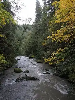
The Dungeness River is a 28-mile (45 km) long[1] river located in the Olympic Peninsula in the U.S. state of Washington. It rises near Mount Constance in the Olympic Mountains within the Olympic National Park, flows through the Buckhorn Wilderness, passes by the town of Sequim, and empties into the Strait of Juan de Fuca at Dungeness Bay, behind the Dungeness Spit.[2] One of its main tributaries is the Gray Wolf River. It is crossed by the Dungeness River Bridge.
| Dungeness River | |
|---|---|
 | |
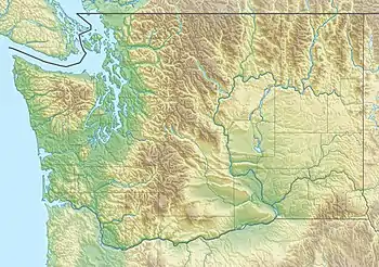 Location of the mouth of the Dungeness River in Washington | |
| Location | |
| Country | United States |
| State | Washington |
| County | Clallam, Jefferson |
| Physical characteristics | |
| Source | Olympic Mountains |
| • coordinates | 47°48′19″N 123°10′0″W[1] |
| Mouth | Strait of Juan de Fuca |
• coordinates | 48°9′3″N 123°8′8″W[1] |
| Length | 28 mi (45 km)[1] |
The river was named for Dungeness Spit. The name "Dungeness" refers to the Dungeness headland in England. It was given by George Vancouver in 1792, who wrote: The low sandy point of land, which from its great resemblance to Dungeness in the British Channel, I called New Dungeness.[3]
Scarborough Island is a small eyot (river island) in the Dungeness River, in Sequim, Washington. About one acre square, it is located near Dungeness Meadows and can be seen from the Dungeness River Dike.
See also
References
- U.S. Geological Survey Geographic Names Information System: Dungeness River
- U.S. Geological Survey Geographic Names Information System: Dungeness Bay
- Phillips, James W. (1971). Washington State Place Names. University of Washington Press. ISBN 0-295-95158-3.
| Authority control |
|
|---|