Dunnavant, Alabama
Dunnavant, also spelled Dunavant, is a census-designated place and unincorporated community in Shelby County, Alabama, United States. Its population was 981 as of the 2010 census.[2] The community's name is probably derived from a local family.[5] A post office was established in 1897 and was in operation until it was closed in 1958.[6]
Dunnavant, Alabama | |
|---|---|
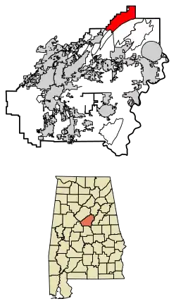 Location of Dunnavant in Shelby County, Alabama. | |
 Dunnavant, Alabama Location of Dunnavant in Shelby County, Alabama. | |
| Coordinates: 33°29′36″N 86°32′39″W | |
| Country | United States |
| State | Alabama |
| County | Shelby |
| Area | |
| • Total | 19.05 sq mi (49.3 km2) |
| • Land | 18.05 sq mi (46.7 km2) |
| • Water | 1.00 sq mi (2.6 km2) |
| Elevation | 666 ft (203 m) |
| Population | |
| • Total | 329 |
| • Estimate (2016)[3] | N/A |
| • Density | 17/sq mi (6.7/km2) |
| Time zone | UTC-6 (Central (CST)) |
| • Summer (DST) | UTC-5 (CDT) |
| Area code(s) | 205, 659 |
| GNIS feature ID | 117649[4] |
Geography
Dunnavant is in central Alabama, in the southernmost extensions of the Appalachian Mountains along Alabama State Route 25 and Shelby County Road 41. Leeds is 6 mi (10 km) north, and the unincorporated community of Vandiver is 4 mi (6 km) southeast on a windy and mountainous route. Shelby County 41 leads southwest as Dunnavant Valley Rd 15 mi (24 km) to Chelsea.
References
- "2016 U.S. Gazetteer Files". United States Census Bureau. Retrieved Jul 17, 2017.
- "U.S. Census website". United States Census Bureau. Retrieved 2011-05-14.
- "Population and Housing Unit Estimates". Retrieved June 9, 2017.
- "Dunnavant". Geographic Names Information System. United States Geological Survey.
- Foscue, Virginia (1989). Place Names in Alabama. Tuscaloosa: The University of Alabama Press. p. 102. ISBN 0-8173-0410-X.
- "Shelby County". Jim Forte Postal History. Archived from the original on 22 October 2014. Retrieved 21 October 2014.
- "Census of Population and Housing". Census.gov. Retrieved June 4, 2016.
Municipalities and communities of Shelby County, Alabama, United States | ||
|---|---|---|
| Cities | 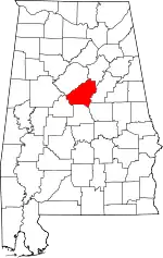 Map of Alabama highlighting Shelby County | |
| Towns | ||
| CDPs | ||
| Unincorporated communities | ||
| Footnotes | ‡This populated place also has portions in an adjacent county or counties | |
| ||
This article is issued from Wikipedia. The text is licensed under Creative Commons - Attribution - Sharealike. Additional terms may apply for the media files.