Dyckesville, Wisconsin
Dyckesville is an unincorporated census-designated place in Brown and Kewaunee counties in the U.S. state of Wisconsin located in the towns of Green Bay and Red River. As of the 2010 census its population was 538.[2] Dyckesville is bypassed by Wisconsin Highway 57, which ran through the community until 2006.[3] Dyckesville is part of the Green Bay Metropolitan Statistical Area.
Dyckesville, Wisconsin | |
|---|---|
Census-designated place | |
 Looking east in Dyckesville | |
 Location in Brown County and the state of Wisconsin. | |
| Coordinates: 44°38′36″N 87°45′40″W | |
| Country | United States |
| State | Wisconsin |
| Counties | Brown, Kewaunee |
| Towns | Green Bay, Red River |
| Area | |
| • Total | 1.041 sq mi (2.70 km2) |
| • Land | 1.041 sq mi (2.70 km2) |
| • Water | 0 sq mi (0 km2) |
| Elevation | 600 ft (200 m) |
| Population (2010) | |
| • Total | 538 |
| • Density | 520/sq mi (200/km2) |
| Time zone | UTC-6 (Central (CST)) |
| • Summer (DST) | UTC-5 (CDT) |
| ZIP code | 54217 |
| Area code(s) | 920 |
| GNIS feature ID | 1564226[1] |
History
Dyckesville was founded around 1860 by Louis Van Dyke, and named for him.[4]
Climate
| ||||||||||||||||||||||||||||||||||||||||||||||||||||||||||||||||||||||||||||||||||||||||||||||||||||||||||||||||||||||||||||
References
- "US Board on Geographic Names". United States Geological Survey. 2007-10-25. Retrieved 2008-01-31.
- "U.S. Census website". U.S. Census Bureau. Retrieved 3 April 2011.
- "Wis. 57 bypass project completed". Green Bay Press-Gazette. 2006-12-01.
- Federal Writers' Project (1941). Wisconsin, a Guide to the Badger State. WPA. p. 305. ISBN 978-1-62376-048-9.
- "NASA Earth Observations Data Set Index". NASA. Retrieved 30 January 2016.
Municipalities and communities of Brown County, Wisconsin, United States | ||
|---|---|---|
| Cities | 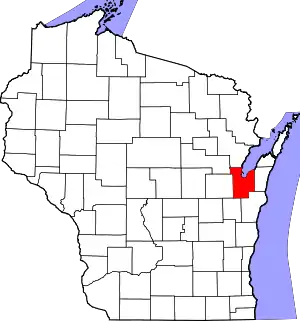 | |
| Villages | ||
| Towns | ||
| CDPs | ||
| Unincorporated communities |
| |
| Indian reservation | ||
| Ghost towns/ neighborhoods | ||
| Footnotes | ‡This populated place also has portions in an adjacent county or counties | |
| ||
Municipalities and communities of Kewaunee County, Wisconsin, United States | ||
|---|---|---|
| Cities | 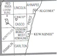 Townships of Kewaunee County | |
| Villages | ||
| Towns | ||
| CDP | ||
| Unincorporated communities | ||
| Former communities | ||
| Footnotes | ‡This populated place also has portions in an adjacent county or counties | |
| ||
| Core city |  | |
|---|---|---|
| Largest municipalities over 10,000 in 2010 | ||
| Municipalities under 10,000 in 2010 | ||
| Counties | ||
This article is issued from Wikipedia. The text is licensed under Creative Commons - Attribution - Sharealike. Additional terms may apply for the media files.