Eagle Township, Barber County, Kansas
Eagle Township is a township in Barber County, Kansas, USA. As of the 2000 census, its population was 42.
Eagle Township | |
|---|---|
 Location in Barber County | |
| Coordinates: 37°12′20″N 098°41′16″W | |
| Country | United States |
| State | Kansas |
| County | Barber |
| Area | |
| • Total | 111.87 sq mi (289.73 km2) |
| • Land | 111.82 sq mi (289.62 km2) |
| • Water | 0.04 sq mi (0.11 km2) 0.04% |
| Elevation | 1,703 ft (519 m) |
| Population (2000) | |
| • Total | 42 |
| • Density | 0.4/sq mi (0.1/km2) |
| GNIS feature ID | 0470475 |
Geography
Eagle Township covers an area of 111.87 square miles (289.7 km2) and contains no incorporated settlements. According to the USGS, it contains one cemetery, Lodi.
The streams of East Cedar Creek, Pump Creek, Salt Fork Arkansas River, Salty Creek and West Cedar Creek run through this township.
External links
- Lodi, Eagle Township, Barber County, Kansas
- The Oak Creek Ranch History, photographs, geology, maps, wildlife and flowers of a ranch in Eagle Township, Barber County, Kansas.
- US-Counties.com
- City-Data.com
Municipalities and communities of Barber County, Kansas, United States | ||
|---|---|---|
| Cities | 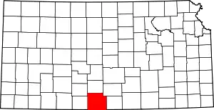 Map of Kansas highlighting Barber County | |
| Unincorporated communities | ||
| Townships | ||
| ||
This article is issued from Wikipedia. The text is licensed under Creative Commons - Attribution - Sharealike. Additional terms may apply for the media files.