Sun City, Kansas
Sun City is a city in Barber County, Kansas, United States, along the Medicine Lodge River. As of the 2010 census, the city population was 53.[6]
Sun City, Kansas | |
|---|---|
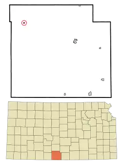 Location within Barber County and Kansas | |
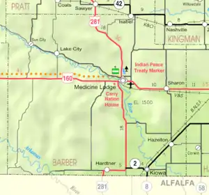 KDOT map of Barber County (legend) | |
| Coordinates: 37°22′45″N 98°55′3″W | |
| Country | United States |
| State | Kansas |
| County | Barber |
| Founded | 1872 |
| Incorporated | 1919 |
| Area | |
| • Total | 0.14 sq mi (0.37 km2) |
| • Land | 0.14 sq mi (0.37 km2) |
| • Water | 0.00 sq mi (0.00 km2) |
| Elevation | 1,670 ft (510 m) |
| Population | |
| • Total | 53 |
| • Estimate (2019)[3] | 48 |
| • Density | 340.43/sq mi (131.16/km2) |
| Time zone | UTC-6 (CST) |
| • Summer (DST) | UTC-5 (CDT) |
| ZIP code | 67143 |
| Area code | 620 |
| FIPS code | 20-69275[4] |
| GNIS ID | 0470423[5] |
History
Sun City was founded in 1872.[7] The first post office in Sun City was established in August 1873.[8]
Geography
Sun City is located at 37°22′45″N 98°55′03″W (37.379041, -98.917485).[9] According to the United States Census Bureau, the city has a total area of 0.14 square miles (0.36 km2), all of it land.[10]
Climate
The climate in this area is characterized by hot, humid summers and generally mild to cool winters. According to the Köppen Climate Classification system, Sun City has a humid subtropical climate, abbreviated "Cfa" on climate maps.[11]
Demographics
| Historical population | |||
|---|---|---|---|
| Census | Pop. | %± | |
| 1880 | 81 | — | |
| 1930 | 404 | — | |
| 1940 | 305 | −24.5% | |
| 1950 | 231 | −24.3% | |
| 1960 | 188 | −18.6% | |
| 1970 | 119 | −36.7% | |
| 1980 | 85 | −28.6% | |
| 1990 | 88 | 3.5% | |
| 2000 | 81 | −8.0% | |
| 2010 | 53 | −34.6% | |
| 2019 (est.) | 48 | [3] | −9.4% |
| U.S. Decennial Census | |||
2010 census
As of the census[2] of 2010, there were 53 people, 23 households, and 16 families residing in the city. The population density was 378.6 inhabitants per square mile (146.2/km2). There were 48 housing units at an average density of 342.9 per square mile (132.4/km2). The racial makeup of the city was 100.0% White.
There were 23 households, of which 21.7% had children under the age of 18 living with them, 65.2% were married couples living together, 4.3% had a male householder with no wife present, and 30.4% were non-families. 30.4% of all households were made up of individuals, and 17.4% had someone living alone who was 65 years of age or older. The average household size was 2.30 and the average family size was 2.75.
The median age in the city was 48.5 years. 17% of residents were under the age of 18; 15.1% were between the ages of 18 and 24; 9.5% were from 25 to 44; 39.6% were from 45 to 64; and 18.9% were 65 years of age or older. The gender makeup of the city was 50.9% male and 49.1% female.
2000 census
As of the census[4] of 2000, there were 81 people, 33 households, and 22 families residing in the city. The population density was 538.8 people per square mile (208.5/km2). There were 50 housing units at an average density of 332.6 per square mile (128.7/km2). The racial makeup of the city was 97.53% White, 2.47% from other races. Hispanic or Latino of any race were 2.47% of the population.
There were 33 households, out of which 27.3% had children under the age of 18 living with them, 57.6% were married couples living together, 9.1% had a female householder with no husband present, and 33.3% were non-families. 33.3% of all households were made up of individuals, and 12.1% had someone living alone who was 65 years of age or older. The average household size was 2.45 and the average family size was 3.09.
In the city, the population was spread out, with 25.9% under the age of 18, 9.9% from 18 to 24, 19.8% from 25 to 44, 29.6% from 45 to 64, and 14.8% who were 65 years of age or older. The median age was 41 years. For every 100 females, there were 80.0 males. For every 100 females age 18 and over, there were 87.5 males.
The median income for a household in the city was $20,625, and the median income for a family was $37,083. Males had a median income of $29,063 versus $17,500 for females. The per capita income for the city was $15,059. There were 26.3% of families and 28.4% of the population living below the poverty line, including 63.6% of under eighteens and none of those over 64.
References
- "2019 U.S. Gazetteer Files". United States Census Bureau. Retrieved July 24, 2020.
- "U.S. Census website". United States Census Bureau. Retrieved 2012-07-06.
- "Population and Housing Unit Estimates". United States Census Bureau. May 24, 2020. Retrieved May 27, 2020.
- "U.S. Census website". United States Census Bureau. Retrieved 2008-01-31.
- "US Board on Geographic Names". United States Geological Survey. 2007-10-25. Retrieved 2008-01-31.
- "2010 City Population and Housing Occupancy Status". U.S. Census Bureau. Retrieved March 6, 2011.
- "Barber County". Blue Skyways. Kansas State Library. Archived from the original on 6 June 2014. Retrieved 4 June 2014.
- "Kansas Post Offices, 1828-1961". Kansas Historical Society. Archived from the original on October 9, 2013. Retrieved 18 June 2014.CS1 maint: unfit URL (link)
- "US Gazetteer files: 2010, 2000, and 1990". United States Census Bureau. 2011-02-12. Retrieved 2011-04-23.
- "US Gazetteer files 2010". United States Census Bureau. Archived from the original on 2012-01-25. Retrieved 2012-07-06.
- Climate Summary for Sun City, Kansas
Further reading
External list
- City
- Schools
- USD 254, local school district
- Historical
- Sun City History from Barber County, Kansas: History and Genealogy.
- "Work Of The Storm Fiend: Sun City Swept by a Cyclone." "Medicine Lodge Cresset", April 26, 1883.
- "Shooting Affray At Sun City" "The Medicine Lodge Cresset", November 19, 1880.
- Maps
- Sun City Map, KDOT
Municipalities and communities of Barber County, Kansas, United States | ||
|---|---|---|
| Cities | 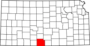 Map of Kansas highlighting Barber County | |
| Unincorporated communities | ||
| Townships | ||
| ||