East End, Queensland
East End is a rural locality in the Gladstone Region, Queensland, Australia.[2] In the 2016 census East End had a population of 59 people.[1]
| East End Queensland | |||||||||||||||
|---|---|---|---|---|---|---|---|---|---|---|---|---|---|---|---|
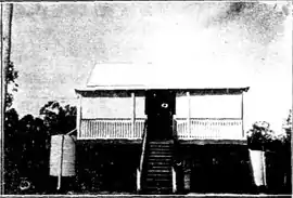 Willmott State School, 1924 | |||||||||||||||
 East End | |||||||||||||||
| Coordinates | 23.9°S 151.0055°E | ||||||||||||||
| Population | 59 (2016 census)[1] | ||||||||||||||
| • Density | 0.3205/km2 (0.830/sq mi) | ||||||||||||||
| Postcode(s) | 4695 | ||||||||||||||
| Area | 184.1 km2 (71.1 sq mi) | ||||||||||||||
| Time zone | AEST (UTC+10:00) | ||||||||||||||
| LGA(s) | Gladstone Region | ||||||||||||||
| State electorate(s) | Gladstone | ||||||||||||||
| Federal Division(s) | Flynn | ||||||||||||||
| |||||||||||||||
Geography
The Bruce Highway enters the locality from the south-west (West Stowe) and exits to the north (Mount Larcom).[3]
East End railway station is a railway station on the Blackwater railway system (23.8755°S 150.9672°E).[4]
History
The area was originally known as Wilmott after a squatter called Wilmott who brought two flocks of sheep into the area in 1855. One flock was situated near a lagoon approximately 1⁄2 mile (0.80 km) long, now called Wilmot Lagoon (23.8519°S 150.9838°E).[5][6]
Willmott State School opened on 26 April 1915.[7] In 1936, it was renamed East End State School. The school closed in 1963.[8] It was located at 23.8782°S 150.9439°E.[9]
In the 2011 census, East End was included with neighbouring Bracewell; together they had a population of 462 people.[10]
In the 2016 census East End had a population of 59 people.[1]
References
- Australian Bureau of Statistics (27 June 2017). "East End (SSC)". 2016 Census QuickStats. Retrieved 20 October 2018.

- "East End – locality in Gladstone Region (entry 49117)". Queensland Place Names. Queensland Government. Retrieved 27 December 2020.
- "Queensland Globe". State of Queensland. Retrieved 5 February 2021.
- "Railway stations and sidings - Queensland". Queensland Open Data. Queensland Government. 2 October 2020. Archived from the original on 5 October 2020. Retrieved 5 October 2020.
- "WILMOTT AND OTHER FARMS". The Capricornian. Queensland, Australia. 15 November 1924. p. 57. Retrieved 13 March 2020 – via Trove.
- "Wilmot Lagoon – waterhole in the Gladstone Region (entry 37586)". Queensland Place Names. Queensland Government. Retrieved 13 March 2020.
- "THE WEEK AT A GLANCE". The Queenslander. Queensland, Australia. 3 April 1915. p. 11. Retrieved 13 March 2020 – via Trove.
- "Agency ID 6166, East End State School". Queensland State Archives. Retrieved 20 April 2014.
- "Langmorn, Queensland" (JPG) (Map). Queensland Government. 1943. Retrieved 13 March 2020.
- Australian Bureau of Statistics (31 October 2012). "Bracewell (SSC)". 2011 Census QuickStats. Retrieved 20 April 2014.