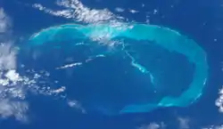
East Island, Hawaii
East Island is a former island, formerly about 11 acres (45,000 m2) in area, one-half mile (800 m) long and 400 feet (120 m) wide.[1] It was the second-largest in the French Frigate Shoals, and one of the Northwestern Hawaiian Islands, approximately 550 miles (890 km) northwest of Honolulu.[2] It was largely washed away in 2018 by the storm surge from Hurricane Walaka.[2][3] The remaining portion of the island above sea level consists of a sandy strip approximately 150 feet (46 m) long.[4]
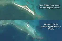 Satellite images of East Island, Hawaii, before (May 2018) and after (October 2018) Hurricane Walaka | |
 East Island | |
| Geography | |
|---|---|
| Location | Pacific Ocean |
| Coordinates | 23°47′14″N 166°12′35″W |
| Archipelago | French Frigate Shoals |
| Adjacent bodies of water | Pacific Ocean |
| Area | 11 acres (4.5 ha) |
| Length | 0.5 mi (0.8 km) |
| Width | 400 ft (120 m) |
| Country | United States |
| State | Hawaii |
| Demographics | |
| Population | 0 (since 1952) |
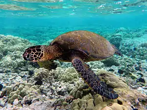
The island, a sand and gravel spit that formed part of the Papahānaumokuākea Marine National Monument, was a habitat for Hawaiian monk seals and green sea turtles, both of which are endangered species.[2] 96% of Hawaii's green sea turtles nest in the French Frigate Shoals, and over half of those were on East Island.[2] Charles Littnan, of the National Oceanic and Atmospheric Administration, described the island as "the most important single islet for [green] sea turtle nesting".[2]
During WW2 a U.S. Coast Guard radio navigation station was built on East Island, and operated from 1944 to 1952.[5]
In the 19th century East island was sometimes called turtle island.[6]
.jpg.webp)
History
_(20157463550).jpg.webp)
The island was surveyed by the Tanager Expedition of 1923 and 1924.[7] At that time it was about 11 acres of land.[8]
In 1932 the USS Quail anchored near East Island, when it used its seaplane to take aerial photographs of the shoals.[9]
In 1935 a "tent city" was placed on East island to support Naval maneuvers in the region, which included exercises with ships and seaplanes.[10]
In October 1936, the USS Wright (AV-1) came to the shoals, and established a base on East island to support a month of seaplane operations.[11]
From November 1944 to October 1952 the U.S. Coast Guard maintained a LORAN radio navigation station on the island.[5] In April 1946 it was badly damaged by a tsunami, and in August 1950 it had to be evacuated due to a typhoon warning.[5] Facilities included 13 buildings including the LORAN building, which was for a radio system to that supported ships and aircraft locating themselves at long distances.[12]
Buildings in the USCG Loran facility included:[13]
- Commanding Officer (CO) quarters & recreational hall
- Two Barracks
- Mess Hall & Galley
- Generator Hut & Storeroom
- 2nd Generator Hut & Machine Shop
- Loran Hut & Radio room
- Aerology Office
- Boatswain's Locker
- Distiller Shed
- Paint Locker
- Vehicle Shed
- Crew's Head (Bathroom hut)
Other structures on the island included water tanks, water pump, and the antennas.[14]
In the 1980s, it was noted as a pupping ground for monk seals.[15]
In the late 20th century it was known as a noted breeding ground for Green sea turtles.[16] In 1997 it was reported to have over 500 turtles nests on the island.[17]
In 2018 most of the island above sea level was washed away by Hurricane Walaka.[18] The storm was a Category 4 storm.[19]
See also
- Desert island
- List of islands
References
- Milman, Oliver (October 24, 2018). "Hawaiian island erased by powerful hurricane: 'The loss is a huge blow'". the Guardian. Retrieved October 29, 2018.
- Eagle, Nathan (October 23, 2018). "This Remote Hawaiian Island Just Vanished". Honolulu Civil Beat. Retrieved October 23, 2018.
- D'Angelo, Chris (23 October 2018). "Remote Hawaiian Island Wiped Off The Map". Huffington Post. Retrieved 23 October 2018.
- https://www.dispatch.com/news/20181104/hurricane-largely-destroys-remote-hawaiian-island
- "LORAN Station French Frigate Shoals". LORAN History. Retrieved 2018-08-10.
- THE NATURAL HISTORY OF FRENCH FRIGATE SHOALS, NORTHWESTERN HAWAIIAN ISLANDS Page 44
- Page 18
- Page 18