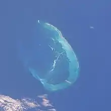
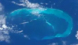
French Frigate Shoals
The French Frigate Shoals (Hawaiian: Kānemilohaʻi) is the largest atoll in the Northwestern Hawaiian Islands. Its name commemorates French explorer Jean-François de La Pérouse, who nearly lost two frigates when attempting to navigate the shoals. It consists of a 20-mile (32 km) long crescent-shaped reef, twelve sandbars, and the 120-foot (37 m) high La Perouse Pinnacle, the only remnant of its volcanic origins. The total land area of the islets is 61.508 acres (24.891 ha). Total coral reef area of the shoals is over 232,000 acres (94,000 ha). Tern Island, with an area of 26.014 acres (10.527 ha), has a landing strip and permanent habitations for a small number of people. It is maintained as a field station in the Hawaiian Islands National Wildlife Refuge by the United States Fish and Wildlife Service. The French Frigate Shoals are about 487 nautical miles (902 km; 560 mi) northwest of Honolulu.

In the 20th century it became involved in WW2 when it was used for Japanese operation to attack Hawaii, and then a small US Naval base was established there to prevent it being used again. After the war it was used by the coast guard for a LORAN station, which was a radio navigation system. By the 21st century it was primarily used for oceanographic and biological study as a nature reserve. Studies at the island helped establish the nature of plastic pollution, and in 2020 one island was designated as contaminated by plastic pollution from the ocean. The reefs are noted for having survived many Pacific storms, although these storms have damaged facilities, wildlife, and significantly reduced the area of some islands.
History
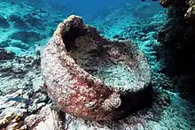
.jpg.webp)
Although there is no evidence of extensive human activity or presence in the area, the earliest human visitors to the French Frigate Shoals probably came from the main Hawaiian Islands, which were settled by Polynesians between 1100 and 1300 AD. [1]
The Hawaiian island chain lay outside the routes followed by early European explorers, and it was not until La Pérouse's near-disastrous discovery that the shoals were known to the outside world. La Pérouse, aboard the frigate Boussole, was sailing westward from Monterey en route to Macau. During the night of 6 November 1786, sailors sighted breakers directly in their path, about a thousand feet ahead. Both the Boussole and her companion vessel, the frigate Astrolabe, were immediately brought about, passing within a few hundred feet of the breakers. At daybreak, the ships returned and mapped the southeastern half of the atoll, as well as finding the rock that would later be named after La Pérouse. La Pérouse named the shoals Basse des Frégates Françaises, the "Shoal of the French Frigates".[1]
The expedition went on to discover the nearby Necker Island.[2] His ships were L'Astrolabe (under command of Fleuriot de Langle) and the La Boussole.[3] La Perouse was on a mission of exploration from the French Academy of Sciences, and they made many discoveries in across the Pacific.[4] The expedition were lost at sea in 1788 while still on the expedition, but were able to send their logs home.[5]
In 1823, the whaling ship Two Brothers sank near Shark island.[6] (This wreck was discovered in the early 21st century)
In 1841 the French Frigate Shoals were visited by the United States Exploring Expedition authorized by President Andrew Jackson.[7] The shoals were visited by the sailing ships, brigs Oregon and Porpoise.[8]
In 1859 the ships Gambia (a bark type ship) and Modern Times ( a clipper ship) both visited the French Frigate Shoals.[9] Also in 1859, the whaling ship South Seaman wrecked on the French Frigate Shoals.[10] Some of the crew, about a dozen were rescued by another vessel in the area, but about 30 crew were left on the island until another ship could retrieve them.[11] In December 1859 the brig Wanderer was also lost on the FFS, but the crew was able to be rescued.[12]
During the late 19th century, American and European companies became interested in the possibility of mining guano in the Hawaiian Islands. U.S. Navy Lieutenant John M. Brooke, sailing on the naval schooner USS Fenimore Cooper, formally took possession of French Frigate Shoals for the United States on 14 January 1859, in accordance with the Guano Islands Act. In 1894, French Frigate Shoals, Kure Atoll, Midway Atoll, and Pearl and Hermes Reef were leased for 25 years by the Republic of Hawaii to the North Pacific Phosphate and Fertilizer Company; however, guano and phosphate deposits at French Frigate Shoals were found to be impractical to mine. The Republic did not formally claim possession of the shoals until 13 July 1895.[1]
French Frigate Shoals was included among the islands acquired by the United States on 7 July 1898, when Hawaii became a United States territory. In 1909 it was made a part of the Hawaiian Islands Bird Reservation.
In 1896 the seal hunting ship Mattie E. Dyer wrecked on the shoals, and the crew abandoned ship in whaleboats making it to a FFS island.[13] There was no water on the island so they sailed the boats to Hawaii.[14]
Early 20th century
In 1902 the Albatross Expedition visited the French Frigate Shoals and studied the birds.[15] Several naturalists visited and published an ornithological report.[16]
In 1903 the ship Connetable de Richmont wrecked on the shoals, but crew escaped on boats to mainland Hawaii.[17]
In 1909 the French Frigate Shoals became part of the Hawaiian Island Reservation and administered by the U.S. Department of Agriculture.[18]
In 1917 the four-mast schooner, a sailing ship, the Churchill wrecked on the French Frigate Shoals.[19] The crew of 12 was able to survive.[20]
The Tanager Expedition visited the French Frigate Shoals in 1923, and did a survey of the islands.[21]
The U.S. Revenue Cutter Service sent many patrols to this region in the early 20th century.[22] The U.S. Revenue Cutter Service vessel USRC Thetis visited the French Frigate Shoals in 1912, 1914, 1915, and 1916.[23] In 1918 the shoals were inspected by the USS Hermes.[24] Shoal inspections in the 1920s and 1930s include ones by the USS Pelican in 1924, the USRC Itasca in 1931 and 1934, and the USCGC Reliance in 1936.[25] (note- the Revenue Cutter service became the Coast Guard in 1915)
In 1932, the USS Quail visited the French Frigate shoals, anchoring near East Island.[26] Using a seaplane tendered from the ship, some of the first aerial photographs of the islands were taken.[27]
In 1936, the USS Wright (AV-1) came to the shoals, and established a base on East island to support a month of seaplane operations.[28]
In 1937, a member of USN seaplane crew died at the French Frigate Shoals while his PK-1 seaplane was moored at the French Frigate Shoals.[29]
World War II; U.S. Coast Guard LORAN
_(20157463550).jpg.webp)
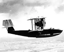
In March 1942, Imperial Japanese Navy planners took advantage of the shoal's isolation to use its protected waters as an anchorage and refueling point for the long-range flying boats employed in their Operation K. The whole plan involving no less than 4 I type submarines of the Imperial Japanese Navy and 2 of their flying boats. Which stopped to refuel in the Shoals from two Imperial submarines, the I-15 and the I-19. In the aftermath of that attack, Commander, U.S. Pacific Fleet Chester W. Nimitz ordered a permanent United States Navy presence at the shoals.[30]
Some US Navy ships that were stationed at the Shoals in 1942 were the Seaplane tender USS Thornton (AVD-11) and the Mine warfare ship USS Preble (DM-20).[31] Over twenty seaplanes (flying boats) were operated from the French Frigate shoals during WW2, and these aircraft would fly reconnaissance flights.[32]
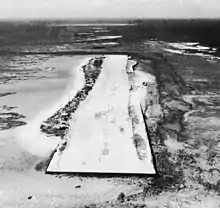
After the Battle of Midway, the United States Navy built a naval air station on Tern Island, enlarging the island sufficiently to support a 3,300-foot (1,000 m) landing strip; Tern Island now has a land area of 26.014 acres (10.527 ha). The station's main function was as an emergency landing site for planes flying between Hawaii and Midway Atoll. French Frigate Shoals Airport comprises what remains of the original seawall, coral and gravel runway, and buildings.[33]
The ship YHB-10 (1000 gross tonnage) arrived at French Frigate Shoals in August 1942, carrying staff to help establish the Naval base there.[34] It was moored on the north side of Tern island and used as a floating barracks.[35] On March 26, 1945 it was sunk as a torpedo practice target near the French Frigate shoals.[36]
The United States Coast Guard operated a LORAN navigation station on East Island until 1952, and Tern Island until 1979. At any one time, 15 to 20 military personnel were billeted to French Frigate Shoals. As with all Coast Guard isolated duty stations, the Service attempted to fill open billets with volunteers. If there were no volunteers for essential billets, the Coast Guard would at times fill open slots as a disciplinary measure.
The LORAN station commanding officer was typically a Lieutenant Junior Grade officer, the executive officer a chief petty officer enlisted rank. The station was staffed with USCG enlisted specialists such as Radioman, Electronic Technician, Fireman, Boatswain's Mates, plus seaman or seaman apprentice nonrated service members (assigned to perform maintenance and other generalized duties).
The Coast Guard designated the French Frigate Shoals billet as "isolated duty," thereby entitling Coast Guard members serving at the station to additional monthly "isolated duty pay." Because of the billet's remoteness, a duty term was limited to one year.
In December 1969 a tsunami devastated the islands, forcing the crew on Tern Island to evacuate the station, which was destroyed. The station was off air from 1 to 6 December.[37]
Whale-Skate island washed away in the 1990s.[38]
FWS Field Station (1979-2012)
A Fish and Wild Life field station was active at the island from 1979 to 2012.[39]
21st century
The United States Fish and Wildlife Service continues to maintain a permanent field station there.[40] In 2000, the atoll became part of the Northwestern Hawaiian Islands Coral Reef Ecosystem Reserve, which was incorporated into the Northwestern Hawaiian Islands National Monument in 2006. In 2009 the islands were evacuated during the approach of Hurricane Neki by landing a USCG C-130 on Tern's coral airstrip.[41]
In 2005, a wreck was found possibly the wreck of the schooner Churchill which ran aground at the French Frigate Shoals in 1917.[42] Martime archologists returned in 2007 and 2008 to try and identify the wreck site, which included items like anchors and equipment.[43]
In 2008 a shipwreck of a 19th century whaling ship was found near Shark island.[44] The wreck was identified in 2011 as the whaling sailing ship Two Brothers, the ship wrecked the night of February 11, 1823 under the command of Captain Pollard (of the ship Essex fame). The crew was able to be rescued by another whaling ship they were on the voyage with, Martha.[45][46][47] Captain Pollard is noted for inspiring the novel Moby Dick when his sailing ship the Essex was rammed by a whale.[48] The discovery was important maritime archeology find for various reasons, and there is only one surviving whaling ship from this period;the wreck had been lost for nearly two centuries.[49] The finding of the Two Brothers was the first discovery of a wrecked Nantucket whaling ship.[47]
There is at least five other vessels that have recorded to have wrecked on the French Frigate Shoals between 1859 to 1917.[50]
In December 2012, 5 people were evacuated from the FFS in advance of a severe storm.[51] They departed by boat from Tern island and travell back to Honolulu.[52] The storm caused damage to some of the facilities on the island including the barracks.[53][54] The US Fish & Wildlife service closed its field station on Tern island at the end of 2012.[55]
In 2016, a NOAA ship conducted a 33 day survey expedition of the French Frigate Shoals, including reporting on the condition of the reefs.[56]
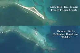
In October 2018, Hurricane Walaka eroded away most of East Island, the second largest island of the French Frigate Shoals.[57][58] About 11 acres of East island were eliminated, which was thought to be caused by the large storm surge that Walaka caused in the area.[59] The hurricane damaged many FFS islands, and underwater many coral reefs were stripped of sealife.[60]
In 2020, the Papahanaumokuakea Marine Debris Project working in conjunction with the Government agencies removed tens of thousands of pounds/kg of debris from the French Frigate Shoals.[61]
Geology and ecology
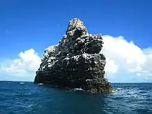
La Perouse Pinnacle, a rock outcrop in the center of the atoll, is the oldest and most remote volcanic rock in the Hawaiian chain. It stands 120 feet (37 m) tall and is surrounded by coral reefs. Because of its shape, the pinnacle is often mistaken for a ship from a distance.[62][63]
Whale-Skate Island is a submerged island in the French Frigate Shoals. These islands suffered considerably from erosion starting in the 1960s, and by the late 1990s, Whale-Skate Island was completely washed over.[64]
The reef system at French Frigate Shoals supports 41 species of stony corals, including several species that are not found in the main Hawaiian Island chain. More than 600 species of marine invertebrates, many of which are endemic, are found there as well.[65]
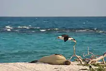
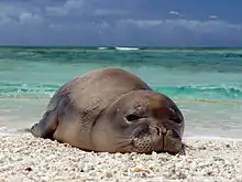
More than 150 species of algae live among the reefs. Especially diverse algal communities are found immediately adjacent to La Perouse Pinnacle. This has led to speculation that an influx of additional nutrients – in the form of guano – is responsible for the diversity and productivity of algae in this environment.[65] The reef waters support large numbers of fish. The masked angelfish (Genicanthus personatus), endemic to the Hawaiian Islands, is relatively common there. Most of Hawaii's green sea turtles travel to the shoals to nest. The small islets of French Frigate Shoals provide refuge to the largest surviving population of Hawaiian monk seals, the second most endangered pinniped in the world.[40]
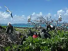
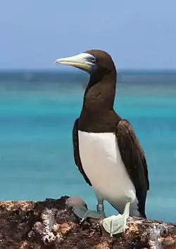
The islands are also an important seabird colony. Eighteen species of seabird, the black-footed albatross, Laysan albatross, Bonin petrel, Bulwer's petrel, wedge-tailed shearwater, Christmas shearwater, Tristram's storm-petrel, red-tailed tropicbird, masked booby, red-footed booby, brown booby, great frigatebird, spectacled tern, sooty tern, blue-gray noddy, brown noddy, black noddy and white tern nest on the islands, most of them (16) on Tern Island. Two species, the blue-gray noddy and the brown booby, nest only on La Perouse Pinnacle. The island also is the wintering ground for several species of shorebird.[66][67]
A three-week research mission in October 2006 by the National Oceanic and Atmospheric Administration (NOAA) led to the discovery of 100 species never seen in the area before, including many that are totally new to science. The French Frigate Shoals project is part of the Census of Coral Reef Ecosystems of the International Census of Marine Life.[68] In addition to scientific analysis, a National Geographic photographer was on board also.[69] The photographer noted the extroadinary range of vibrant colors and shapes among the coral life.[70] An expert on coral life in this region of ocean, estimated they discovered 11 new species of coral.[71]
The shark population and type was studied in 2009, and it was determined that some of the species in the area include:[72]
- Galapagos (Carcharhinus galapagensis)
- Gray reef (Carcharhinus amblyrhynchos)
- Tiger (Galeocerdo cuvier)
Whale Skate and Trig islands were noted as Monk seal pupping areas before they eroded away.[73]
List of corals of the French Frigate Shoals
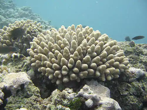
%252C_lobe_coral_(Porites_lobata)%252C_and_finger_coral_(Porites_compressa)_(5762963067).jpg.webp)
Corals found in the FFS between 1907-2006, as reported in a 2011 paper by Brainard et al.:[74]
- Coral unidentified, sp.18
- L. incrustans
- P. eydouxi
- Acropora cerealis
- L. sp.22 cf. incrustans
- P. sp.10 cf.laysanesis
- A. gemmifera
- L. mycetoseroides
- P. ligulata
- A. humilis
- L. cf. papyracea sp19
- P. meandrina
- A. nasuta
- L.cf.scabra sp17
- P. molokensis
- A. paniculata
- Pavona duerdeni
- P. sp.32 cf. verrucosa
- A.sp.1 (prostrate)
- P. maldivensis
- P. sp.33 cf.zelli
- A. sp.28 cf. retusa
- P. varians
- P. sp.11 cf. capitata
- A. valida
- Balanophyllia sp. (pink)
- P. sp. 15 (paliform lobes)
- A.sp.29 (table)
- Cladopsammia eguchii
- Porites brighami
- A. sp.30 cf. palmerae
- Tabastraea coccinea
- P. compressa
- A.sp. 20 (neoplasia/tumor?)
- Cyphastrea ocellina
- P. sp.23 (arthritic fingers)
- A.sp.26 cf. loripes
- Leptastrea agassizi
- P. duerdeni
- Montipora capitata
- L. bewickensis
- P. evermanni
- M. flabellate
- L. purpurea
- P. hawaiiensis
- M. patula
- L. pruinosa
- P. lobata
- M. sp.4 cf. incrassate
- L. sp.8 cf.
- F. hawaiiensis
- P. sp.21 cf. lobata
- M. sp.7 (foliaceous)
- Cycloseris tenuis
- P. sp. 16 cf. lutea
- M. tuberculosa
- C. vaughani
- P. sp.27 (columns)
- M. sp.24 (irregular)
- Diaseris distorta
- P. sp.13 cf. solida
- M. verrilli
- Fungia scutaria
- Psammocora nierstraszi
- Leptoseris hawaiiensis
- Pocillopora damicornis
- P. stellate
List of nesting bird species
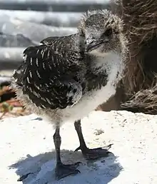
There is different categories of birds that can be seen at tern, some use shoals as Migratory stopover, while others actually use it for nesting.[75] By the early 21st century there was 18 species known to nest at French Frigate shoals, the most prolific being the Sooty Tern.[76]
Examples:[77]
- Black-Footed Albatross (Diomedea nigripes)
- Blue-Gray Noddy (Procelsterna cerulea)
- Black Noddy (Anous minutus)
- Bonin Petrel (Pterodroma hypoleuca)
- Brown Noddy (Anous stolidus)
- Bulwer’s Petrel
- Gray-backed (TernSterna lunata)
- Great Frigatebird (Fregata minor)
- Laysan Albatross (Diomedea immutabilis)
- Lesser Frigatebird (Frigata ariel)
- Masked Booby (Sula dactylatra)
- Red-Footed (BoobySula sula')
- Red-Tailed Tropicbird (Phaethon rubricauda)
- Sooty Tern (Sterna fuscata)
- Tristram’s Storm Petrel (Oceanodroma tristrami)
- White Tern (Gygis alba)
- Wedge-tailed (ShearwaterPuffinus pacificus)
Islands

This table lists the islands of the French Frigate Shoals:
| Island | Census- block | Original Area m2 | Coordinates |
|---|---|---|---|
| Shark Island | 1010 | 4294 | 23°51′09.9″N 166°19′26.3″W |
| Tern Island | 1009 | 105276 | |
| Trig Island | 1008 | 23298 | |
| Skate Island 1) | 1007 | 12808 | |
| Whale Island 1) | 1007 | 19212 | |
| Disappearing Island | 1002 | 9800 | |
| Little Gin Island | 1003 | 19448 | |
| Gin Island | 1004 | 9708 | |
| Near Island 2) | - | 400 | 23°48′20″N 166°13′46″W |
| Bare Island 3) | - | 400 | |
| East Island 4) | 1005 | 35853 | |
| Mullet Island 5) | 1006 | 2462 | |
| Round Island 5) | 1006 | 3078 | |
| La Perouse Pinnacle | 1011 | 3677 | |
1) Whale-Skate Island, currently a double island, is also listed in the census documents together as a block, with an area of 32,020 m2. The shares of the islands are estimated (40 and 60 percent).
2) 1971 it was reported that Near Island, although recorded on maps, would be submerged at high tide.
3) Bare Island can be seen on satellite images but[78] is not listed in the Census Tract.[79] A 1971 publication says Bare Island has an area of 0.1 acres (about 400 m2).[80]
4) As of October 2018, East Island has mostly submerged.[57][58]
5) Round and Mullet Islands in census documents found together as a block 1006, together with an area of 5540 m2. The shares are valued according to a report from 1971 (0.4 and 0.5 acres).
The two major islands of the French Frigate shoals were Tern island and East island, and there is also a tall rock pinnacle. Many of the smaller islands have been washed over, and finally in 2018 East island was largely washed away. Tern island is protected by a seawall that originates from when it was expanded in the 1940s to become a Naval Air base.
Islands known to have been notably washed away or reduced by 2018 include Whale-Skate, Trig, and East island.[81]
Trig island
Trig island is located at 23'52'N x 166'15' and is about 10 acres of area of which almost six have vegitation.[82] The island is about 1200 feet long and between 200-300 feet wide.[83] However, the island is known to have weathered considerably between the 1930s and 1960s.[84] It was surveyed several times in the 1920s and 1930s.[85] In the early surveys it was noted as the highest of FFS sand islands rising to 20 feet above sea level.[86] By 2018 it mostly washed away.[87]
Whale-Skate island
Whale-Skate island used to be two separate islands but were combined by a sand bar in the 20th century.[88] The Whale-Skate island was about 2100 feet long and 16.8 acres.[89]
In 1923 they were surveyed as two separate islands, Whale island and Skate island.[90] In the 1950s it was noted they had been connected by a sand bar several feet high.[91]
In the 1980s Whale-Skate island was about 6.8 ha (16.8 acres) and noted as a pupping area for seals.[92]
See also
- List of Guano Island claims
- List of reefs
- List of islands
- Desert island
References
- Marts, Chris. "Tern Island: History". college.wfu.edu. Archived from the original on 27 April 2019. Retrieved 10 August 2018.
- Mokumanamana (Necker Island)
- Novaresio, 1996. p. 181 "Lapérouse ships, Astrolabe and Boussole"
- THE NATURAL HISTORY OF FRENCH FRIGATE SHOALS, NORTHWESTERN HAWAIIAN ISLANDS Page 39
- THE NATURAL HISTORY OF FRENCH FRIGATE SHOALS, NORTHWESTERN HAWAIIAN ISLANDS Page 39
- THE NATURAL HISTORY OF FRENCH FRIGATE SHOALS, NORTHWESTERN HAWAIIAN ISLANDS Page 39
- THE NATURAL HISTORY OF FRENCH FRIGATE SHOALS, NORTHWESTERN HAWAIIAN ISLANDS Page 40
- THE NATURAL HISTORY OF FRENCH FRIGATE SHOALS, NORTHWESTERN HAWAIIAN ISLANDS Page 40
- THE NATURAL HISTORY OF FRENCH FRIGATE SHOALS, NORTHWESTERN HAWAIIAN ISLANDS Page 40
- THE NATURAL HISTORY OF FRENCH FRIGATE SHOALS, NORTHWESTERN HAWAIIAN ISLANDS Page 42
- THE NATURAL HISTORY OF FRENCH FRIGATE SHOALS, NORTHWESTERN HAWAIIAN ISLANDS Page 42
- THE NATURAL HISTORY OF FRENCH FRIGATE SHOALS, NORTHWESTERN HAWAIIAN ISLANDS Page 42
- THE NATURAL HISTORY OF FRENCH FRIGATE SHOALS, NORTHWESTERN HAWAIIAN ISLANDS Page 44
- THE NATURAL HISTORY OF FRENCH FRIGATE SHOALS, NORTHWESTERN HAWAIIAN ISLANDS Page 44
- 1962-, Parshall, Jonathan B. (2005). Shattered sword : the untold story of the Battle of Midway. Tully, Anthony P., 1961-. Washington, D.C.: Potomac Books. ISBN 1574889230. OCLC 60373935.CS1 maint: numeric names: authors list (link)
- 70 Years Ago: Battle of Midway Island
- Historic Feature: Flying Boats at French Frigate Shoals
- "Abandoned & Little-Known Airfields: Western Pacific Islands". www.airfields-freeman.com. Archived from the original on 4 September 2014. Retrieved 10 August 2018.
- [ https://www.history.navy.mil/research/histories/ship-histories/danfs/y/yhb10.html]
- The Coral Carrier Page 99
- "LORAN STATION FRENCH FRIGATE SHO". www.loran-history.info. Retrieved 10 August 2018.
- Scott, Susan (3 June 2004). "Tern Island: Noah's ark of the Hawaiian Islands. Part 1: Beauty more than guano deep". archives.starbulletin.com. Retrieved 10 August 2018.
- "U.S. Coast Guard aircrew rescues 10 from French Frigate Shoals". CoastGuardNews.com. 22 October 2009. Retrieved 29 March 2017.
- Kelly, Gleason; Raupp, Jason T. (2010). "Lost & Found: In Papahānaumokuākea Marine National Monument: The Possible Wreck Site of the Nantucket Whaleship Two Brothers". Historic Nantucket. 60 (3): 13–17. ISSN 0439-2248.
- Philbrick, Nathaniel (2001). In the Heart of the Sea: The Tragedy of the Whaleship Essex. New York: Penguin. pp. 208–210. ISBN 978-0-14-100182-1. OCLC 46949818.
- "Lost Whaling Shipwreck with Link to Melville's Moby-Dick Discovered in the Northwestern Hawaiian Islands". National Oceanic and Atmospheric Administration. 11 February 2011. Retrieved 13 February 2011.
- Biologists Evacuated from Remote Pacific Field Station
- ECHNICAL SUPPORT DOCUMENT TO THE PRELIMINARY ASSESSMENT OF THE FWS – HAWAIIAN ISLANDS NATIONAL WILDLIFE REFUGE: TERN ISLAND SITE IN THE FRENCH FRIGATE SHOALS, HAWAIʻI
- NOAA Ship Hi'ialakai surveys French Frigate Shoals
- Atkin, Emily (24 October 2018). "Climate change keeps wiping out Pacific islands". The New Republic. Retrieved 25 December 2018.
- Jacobs, Julia (25 October 2018). "East Island, Remote Hawaiian Sliver of Sand, Is Largely Wiped Out by a Hurricane". The New York Times. Retrieved 24 December 2018.
- Researchers observe coral reef damage and invasive alga in Papahānaumokuākea Marine National Monument August 2019
- Rauzon, Mark (2001). Isles of Refuge: Wildlife and History of the Northwestern Hawaiian Islands. University of Hawaii Press. p. 55. ISBN 0-8248-2330-3.
- "NWHI: About: French Frigate Shoals". Northwestern Hawaiian Islands Multi-Agency Education Project. Archived from the original on 13 February 2007. Retrieved 9 October 2016.
- Philander, Dr. George (2008). Encyclopedia of Global Warming and Climate Change. Thousand Oaks: SAGE Publications. ISBN 9781452265889. OCLC 815786021.
- "French Frigate Shoals (Kānemiloha'i)". www.papahanaumokuakea.gov. Retrieved 10 August 2018.
- HATFIELD, JEFF S.; REYNOLDS, MICHELLE H.; SEAVY, NATHANIEL E.; KRAUSE, CRYSTAL M. (24 May 2012). "Population Dynamics of Hawaiian Seabird Colonies Vulnerable to Sea-Level Rise". Conservation Biology. 26 (4): 667–678. doi:10.1111/j.1523-1739.2012.01853.x. ISSN 0888-8892. PMID 22624702.
- "TECHNICAL SUPPORT DOCUMENT TO THE PRELIMINARY ASSESSMENT OF THE FWS – HAWAIIAN ISLANDS NATIONAL WILDLIFE REFUGE: TERN ISLAND SITE IN THE FRENCH FRIGATE SHOALS, HAWAIʻI" (PDF). September 2014.
- "New Species and New Records of Marine Species Discovered in the Northwestern Hawaiian Islands Marine National Monument". ucsdnews.ucsd.edu. Retrieved 10 August 2018.
- The shark assemblage at French Frigate Shoals atoll, Hawai'i: species composition, abundance and habitat use Jonathan J Dale 1 , Austin M Stankus, Michael S Burns, Carl G Meyer ]
- # lat = 23.792563 & lon = -166.2015957 & z = 19 & l = 5 & m = b Bare in Iceland satellite image. Here, the length and width of about 25 meters and 6 are measured, or in an area of approximately 150 m².
- PDF bei www.statecountymaps.com Archived 22 June 2015 at the Wayback Machine
- A. Binion Amerson jr.: The Natural History of French Frigate Shoals, Northwestern Hawaiian Islands. Atoll Research Bulletin No. 150, 1971, Seite 28: Bare Island ... is awash at high tide and is usually about 100 feet long, 10 feet wide, and 4 feet high. It covers an area of 0.1 acre. Wetmore (ms.) in 1923 described it as "60 yards long by 10 wide, merely a ridge of sand rising 5 feet above the water and evidently swept" by waves.
- Page 17
Bibliography
External links
| Wikimedia Commons has media related to French Frigate Shoals. |
- The French Frigate Shoals Web Page
- Quick Facts on French Frigate Shoals from the PBS Ocean Adventures site
 | ||
| Authority control |
|
|---|