Eisenerz
Eisenerz (German pronunciation: [ˈaɪ̯zn̩ˌʔeːɐ̯t͡s]; "Iron ore") is a market place and old mining town in the Austrian state of Styria, 68 mi (109 km). N.W. of Graz by rail. Pop. (2001) 6,400. It is situated in the deep Erzbach Valley, dominated on the east by the Pfaffenstein 1871m, (6140 ft), on the west by the Kaiserschild 2084 m (6830 ft), and on the south by the Erzberg 1465 m (5030 ft). It has a medieval fortified church, a Gothic edifice founded by Rudolph of Habsburg in the 13th century and rebuilt in the 16th century.[3]
Eisenerz | |
|---|---|
.JPG.webp) Eisenerz with Erzberg | |
 Coat of arms | |
 Eisenerz Location within Austria | |
| Coordinates: 47°33′00″N 14°53′00″E | |
| Country | Austria |
| State | Styria |
| District | Leoben |
| Government | |
| • Mayor | Christine Holzweber (SPÖ) |
| Area | |
| • Total | 124.69 km2 (48.14 sq mi) |
| Elevation | 736 m (2,415 ft) |
| Population (2018-01-01)[2] | |
| • Total | 4,048 |
| • Density | 32/km2 (84/sq mi) |
| Time zone | UTC+1 (CET) |
| • Summer (DST) | UTC+2 (CEST) |
| Postal code | 8790 |
| Area code | 03848 |
| Vehicle registration | LN |
| Website | www.eisenerz.co.at |
At the turn of the past century the Erzberg (Ore Mountain) furnished such rich ore that it was quarried in the open air like stone, in the summer months. There is documentary evidence of the mines having been worked as far back as the 12th century. They afforded employment to two or three thousand hands in summer and about half as many in winter, and yielded some 800,000 tons of iron per annum. During World War II, a subcamp of Mauthausen concentration camp was located here. It provided slave labour for local industry.[4] Eisenerz was connected with the mines by the Erzberg Railway, a bold piece of engineering work, fourteen miles (21 km) long, constructed on the Abt's rack-and-pinion system. It passed through the pastoral scenery, before descending to Vordernberg, a center of the iron trade situated on the south side of the Erzberg. Eisenerz then possessed, in addition, twenty-five furnaces, which produce iron, and particularly steel, of high quality.[3] Today the Erzberg is home to motocross races.
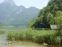
A few miles northwest of Eisenerz stands Leopoldstein Castle, and near it Leopoldstein Lake. This lake, with its dark green water at an elevation of 2,028 feet (618 m), and surrounded on all sides by high peaks, is not large and has a depth of 100 ft (30 m).[3]
History
In Eisenerz, copper smelting was a major activity from the 15th century to the 13th century BC.[5]
Population
| Year | Pop. | ±% |
|---|---|---|
| 1928 | 6,945 | — |
| 1939 | 12,395 | +78.5% |
| 1944 | 18,419 | +48.6% |
| 1948 | 11,103 | −39.7% |
| 1956 | 12,679 | +14.2% |
| 1992 | 7,965 | −37.2% |
| 2000 | 6,750 | −15.3% |
| 2005 | 5,839 | −13.5% |
| 2007 | 5,566 | −4.7% |
| 2013 | 4,655 | −16.4% |
References
- "Dauersiedlungsraum der Gemeinden Politischen Bezirke und Bundesländer - Gebietsstand 1.1.2018". Statistics Austria. Retrieved 10 March 2019.
- "Einwohnerzahl 1.1.2018 nach Gemeinden mit Status, Gebietsstand 1.1.2018". Statistics Austria. Retrieved 9 March 2019.
- Chisholm 1911.
- Christine O'Keefe.Concentration Camps.wwwtartanplace.com/tartanhistory/concentrationcamps.html
- E. Aidona et al. (2006) Spatial distribution of archaeomagnetic vectors within archaeological samples from Eisenerz (Austria), Geophysical Journal International 166:1, pp. 45-58 Geophysical Journal International
 This article incorporates text from a publication now in the public domain: Chisholm, Hugh, ed. (1911). "Eisenerz". Encyclopædia Britannica. 9 (11th ed.). Cambridge University Press. p. 136.
| Authority control |
|---|